Written testimony from the public may be submitted via email to cdp@hawaiicounty.gov or delivered in person to Hilo or Kona Planning Department by Monday, Dec. 12. During the meeting, Action Committee members are set to engage in "an exercise to establish priority implementation projects and interests. Discussion will include exploring mutual interests between action Committee members to create investigatory subcommittees and community liaison groups, as applicable. Joint initiatives with community members or partners are encouraged."
See Kaʻū Community Development Plan, the meeting agenda, list of committee members and much more at https://www.planning.hawaiicounty.gov/general-plan-community-planning/cdp/kau. Many documents related to Kaʻū Community Development Plan's creation and implementation can be seen at: https://records.hawaiconty.gov/Weblink/1/fol/9059/Row1.aspx. Documents can also be requested by calling 80-961-8288 or email cdp@hawaiicounty.gov.
 |
Kanonone Waterhole at Pōhue Bay is an anchialine pond that hosts endemic and native species. Photo by Shalan Crysdale |
DEPARTMENTS OF LAND & NATURAL RESOURCES, AGRICULTURE AND HAWAIIAN HOME LANDS chiefs will be announced by Gov. Josh Green later this month. He convened his first cabinet meeting Wednesday at the Hawai‘i State Capitol "to discuss immediate priorities and start tackling the state’s most pressing issues, including the state budget." Directors and Deputies for 14 state departments were assembled. Directors and Deputy Directors require confirmation by the state Senate. The tenure of those leading DLNR, DOA and DHHL during the Gov. David Ige administration, continue through January.
 |
| Kaʻū Hawaiian Home Lands are outlined in red. |
Hawaiian Home Lands in Kaʻū are located at South Point, above Waiohinu and above Ninole and Punalu'u, plus houselots in Discovery Harbour.
See the DHHL plan at dhhl.hawaii.gov/act279. See story on the plan in Monday's Ka'u News Briefs at: http://kaunewsbriefs.blogspot.com/2022_12_05_archive.html
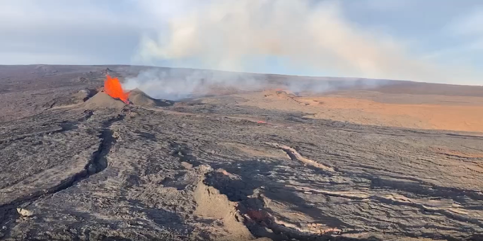
FISSURE THREE STOPPED FEEDING THE LAVA LOBE HEADED TOWARD SADDLE ROAD, and no longer threatens crossing it. The USGS 8 a.m. update on Thursday says, "The Northeast Rift Zone eruption of Mauna Loa continues with a major change overnight. The fissure 3 (F3) vent continues to erupt but the supply of lava appears to be much reduced this morning. Lava is overtopping channels near the vent with flows extending no farther than 2.5 mi (4 km) from the vent. The channels below this point appear drained of lava and probably no longer feed the main flow front.
"As of 5:30 a.m. today, Dec. 8, the flow front was stalled about 1.7 mi (2.8 km) from the Daniel K. Inouye Highway (Saddle Road). The lava flow is now inactive for most of its lower length, but the flow front may appear to advance a little as it settles."
can be found on the VMAP Vog Forecast Dashboard: http://weather.hawaii.edu/vmap/new/.
USGS reported that "Tremor (a signal associated with subsurface fluid movement) continues beneath the currently active fissure. This indicates that magma is still being supplied to the fissure, and activity is likely to continue as long as we see this signal."
There is no active lava within Moku'āweoweo caldera nor the Southwest Rift Zone. "We do not expect any eruptive activity outside the Northeast Rift Zone," USGS concluded.
See the most recent eruption map at: https://www.usgs.gov/media/images/most-recent-mauna-loa-northeast-rift-zone-eruption-map
See info on lava viewing: https://hawaii-county-volcano-hazards-hawaiicountygis.hub.arcgis.com/ See streaming video of the fissure 3 fountains can be found at https://www.youtube.com/usgs/live.
A HIGH SURF ADVISORY FOR KA'Ū'S EAST SHORES and up the coast has been issued by the National Weather Service through Friday evening. Areas affected include Upolu Point in North Kohala through the Hamakua Coast to South Point in Kaʻū. A High Surf Advisory means surf will be higher than normal, shore break, and dangerous currents can make swimming difficult and dangerous. "Beach-goers, swimmers, and surfers should exercise caution and heed all advice given by Ocean Safety Officials," is the advice of NWS.
 |
| See The Ka'u Calendar in the mail and in stands from Volcano through Miloli'i. Also see stories daily on facebook and at www.kaunewsbriefs.blogspot.com |


.heic)


.jpg)

