About The Kaʻū Calendar

Monday, August 26, 2024

Kaʻū News Briefs Aug. 26, 2024

This house that gained fame years ago as the Hobbit House bed and breakfast was hit by a river of mud and rocks during
Hurricane Hone. Now a beekeeper's home, it is located on Ha'ao Springs Road in Wai‘ōhinu. Photo from Trip Advisor
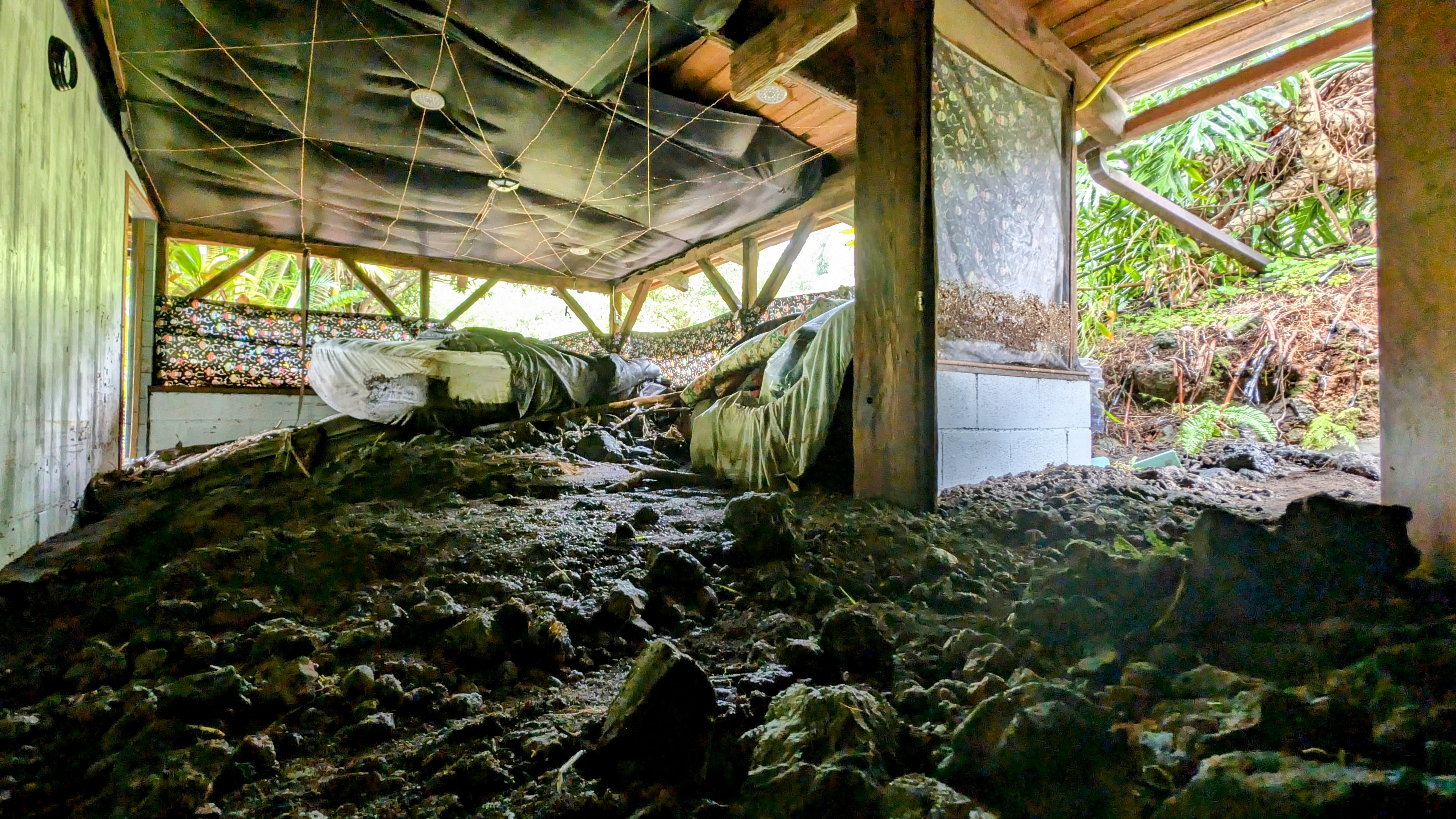
A stream of dirt and rock came through the Hobbit House in Wai‘ōhinu on Sunday.
Photo by Bob Martin

More mud traveled through the home near Ha'ao Springs. Photo by Bob Martin
HURRICANE HONE'S FLOODWATERS LEFT A LOT OF MUD inside this house below Ha'ao Springs on Sunday. A rivulet of mud, rocks and water cut from Pu'ulena gulch through the property in Wai‘ōhinu Homesteads up Ha'ao Springs Road off Hwy 11 and flowed into the kitchen and back room.
    The dwelling earned the name the Hobbit House when it was built decades ago and became a popular Bed & Breakfast. It is currently the home of a mother and beekeeper son, who said he will be trying to recover his inventory of harvested honey through which he makes a living. The two said they will attempt to raise money to repair the home.
    A county crew was working on Ha'ao Springs Road on Monday to clear it from debris.

Rocks from the flood piled up against thte Hobbit House. Photo by Bob Martin


The floodway that cut through the bottom of the Hobbit House.  Photo by Bob Martin
A County crew works to clear debris from Ha'ao Springs Road in Wai‘ōhinu on Monday. Photo by Bob Martin


To read comments, add your own, and like this story, see facebook.com/kaucalendar. See upcoming events, print edition and archive at kaunews.com. Support this news service with advertising at kaunews.com. 7,500 copies in the mail and on stands.

FOLLOWING HURRICANE HONE, FARMERS AND RANCHERS are encouraged by University of Hawai'i's agriculture Cooperative Extension Service to report damages and review or consider obtaining crop insurance. A statement from the Ag Extension recommends that if there are home, farm, ranch, trees, crop and/or structures sustained damages from Hurricane Hone's winds and/or rain, contact home and crop insurance agents immediately.
    The Ag agents recommend documentation of all damages with (clear and focused) photos and/or video. Review inventory and take note of anything damaged or missing. Be sure to receive clearance from the insurance agent before doing any clean-up, repairs, or replacements related to an insurance claim.
    A USDA Farm Service Agency Bulletin has been issued, called Preparation for State of Hawai'i Farm Service Agency Producer. It says, "Tropical storm Hone is one of three storms in the Pacific Basin that may have some impact on your farm, ranch and your crop(s) or livestock. As current or future FSA program participants, we suggest you document and update your personal farm inventory/production records and take pictures before the impact of a disaster event. Should you sustain any type of damage, document, take pictures after the disaster event and contact County FSA Offices." See https://www.fsa.usda.gov/state-offices/Hawaii/service-centers/index?utm_medium=email&utm_source=govdelivery. Those without federal Risk Management Agency crop insurance may qualify for assistance from FSA. Inquire with the local FSA office.
     The ag agents said,  "Crop insurance is like life, medical, and car insurance. If you don't have a current policy when an emergency occurs, an insurance company will not help pay for your losses and recovery. Consider crop insurance policies before storms and hurricanes cause damage and be sure to sign up during their open enrollment period. Farm information and records will be required by the insurance agent."
    Agriculturalists who would like information about crop insurance, visit: http://bit.ly/2eVzuc5. Click on "List of Crops That Can Be Insured" on the left side of the page or scroll down to photos of fruit and nut trees and factsheets for Hawaii's insurable crops. They provide an idea of deadlines and other insurance information. Contact an agent for updated details and to answer any questions. The deadline to enroll or make changes to existing policies is Dec. 31st for banana tree, coffee fruit, coffee tree, macadamia nut, and papaya tree crop insurance.
To read comments, add your own, and like this story, see facebook.com/kaucalendar. See upcoming events, print edition and archive at kaunews.com. Support this news service with advertising at kaunews.com. 7,500 copies in the mail and on stands.

IF IMPACTED BY HONE, farmers and ranchers in County of Hawai'i can complete the COH Civil Defense Agency Public Damage Report
at https://survey123.arcgis.com/share/13ffdc337b544dc0a8665fcdf9e67957. Information provided in this report will ensure that the County of Hawai'i can send a damage assessor to assess the damage caused by a natural or man-made disaster. The data collected will allow County officials to determine if this jurisdiction qualifies for any state or federal assistance, as well as to assist with hazard mitigation planning.

To read comments, add your own, and like this story, see facebook.com/kaucalendar. See upcoming events, print edition and archive at kaunews.com. Support this news service with advertising at kaunews.com. 7,500 copies in the mail and on stands.

NĀ’ĀLEHU ELEMENTARY AND KAʻŪ HIGH & PĀHALA ELEMENTARY will reopen on Tuesday. With Hwy 11 reopening one lane late Monday at Kawā flats, following closure due to flooding from Hurricane Hone, family, school and public transportation will be able to bring students and staff to and from the schools. 


Sunday, August 25, 2024

Kaʻū News Briefs Aug. 25, 2024

Hurricane Hone waters pass by Wong Yuen Store in Wai‘ōhinu on Sunday morning. Photo by Geneveve Fyvie

NO SCHOOL AT NĀ’ĀLEHU ELEMENTARY, KAʻŪ HIGH & PĀHALA ELEMENTARY on Monday, following the arrival of Hurricane Hone. Principal Sharon Beck in Pāhala and Vice Principal Ku'ulei Pablo in Nāʻālehu sent out the announcement Sunday evening as bands of rain continued across Kaʻū and a flood warning remained in place.
    The tropical storm warning was dropped and Hone went back to being a tropical storm as she pulled away from Hawai'i Island. Electrical outages were mostly been repaired, but rain was expected for several more days, following Hurricane Hone skirting South Point, 45 miles offshore, Sunday morning.
     The message from the schools says:

   "We hope this message finds. you and.your family safe and well after the impacts of Hurricane Hone over the weekend.
    "The storm brought heavy rain, flooding, downed trees and power outages, creating challenges throughout our community. At this time, because Highway 11 is closed due to hazardous conditions, our school will be closed tomorrow, Monday, Aug. 26 to ensure the safety of our students, staff and families. We will update you when new information becomes available."

To read comments, add your own, and like this story, see facebook.com/kaucalendar. See upcoming events, print edition and archive at kaunews.com. Support this news service with advertising at kaunews.com. 7,500 copies in the mail and on stands.

Flooding in Wai‘ōhinu on Sunday morning. Photo by Geneveve Fyvie

Hurricane Hone flooded Wai‘ōhinu on Sunday morning. Photo by Bob Martin

Looking to ride some flood waters on Hwy 11 in Wai‘ōhinu on Sunday. Photo by Bob Martin

Huricane Hone's water comes into the graveyard at Wai‘ōhinu on Sunday morning.
Photo by Bob Martin
TROPICAL STORM HONE BECAME A HURRICANE OVERNIGHT. THE EYE PASSED SOUTH POINT, 45 MILES OFFSHORE ON SUNDAY MORNING. Hone dropped a lot of water on Kaʻū, which helps relieve drought. She also threw a lot of wind on the island overnight, bringing down branches and some trees, before heading off into the Pacific and returning to tropical storm status Sunday night.
    Hone flooded Hwy 11 at Kawā Flats and at Wai‘ōhinu. Hone left Ka'alaiki Road - the old sugar can haul road between Pāhala and Nāʻālehu - flooded and blocked at gulches.
     County and police department crews are manning the blocked roads.
     Wood Valley residents have been trapped above the flooded ford since 2 a.m. Sunday morning, with gulches flooding inside the farm community blocking smaller roads.
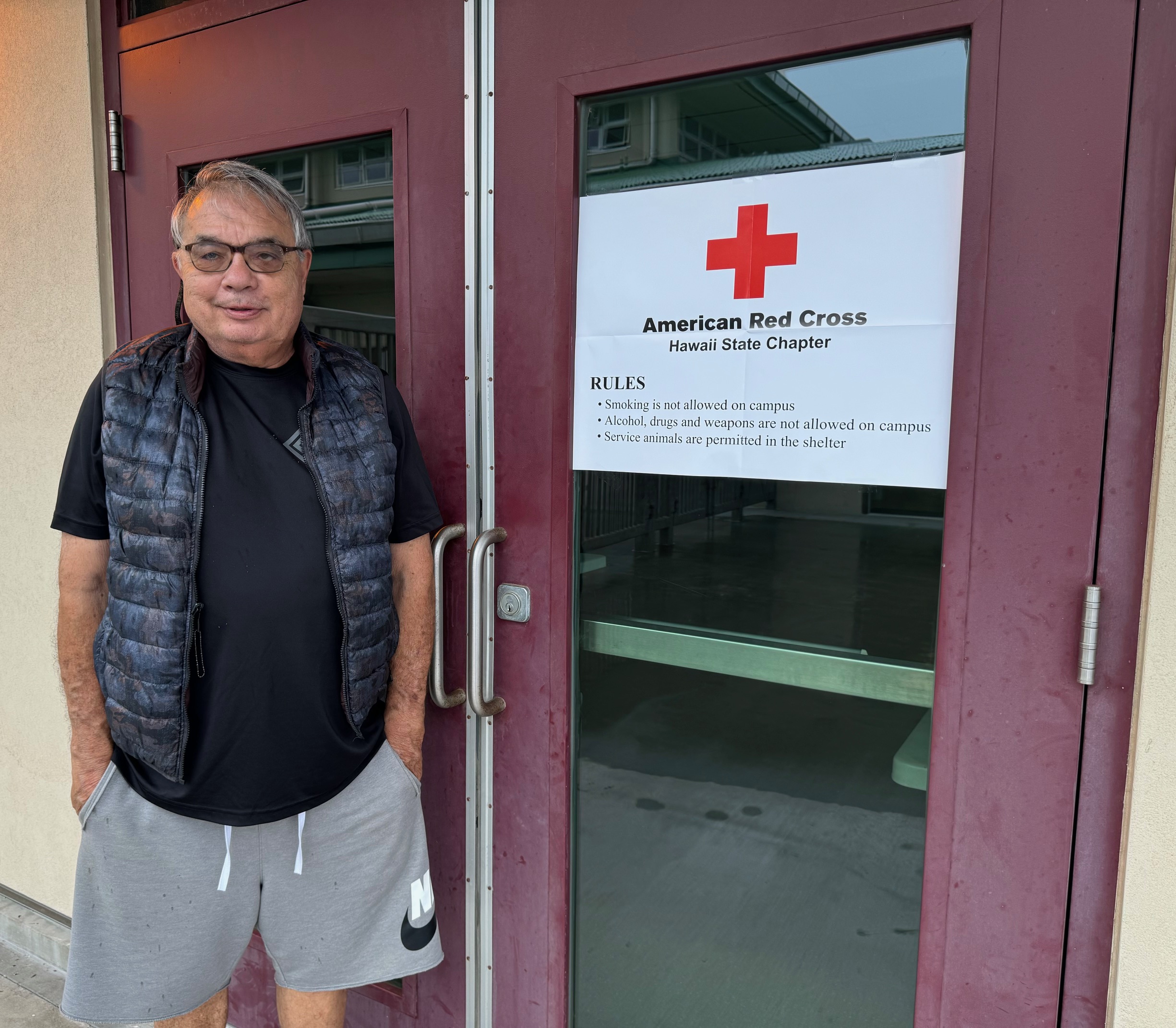
     County/ Red Cross shelters remained open at Kaʻū Herkes Gym annex in Pāhala and Nāʻālehu Community Center on Sunday.
    All Hele On Bus Routes were cancelled for this area. Punalu'u and Whittington Beach Parks were closed, with all camping permits cancelled. State Department of Land & Natural Resources closed 'Ainapo cabin, Keanakolu cabin and Waimanu campsites.
      Even with the rain, Department of Health maintains a no-burn during the drought directive through Aug. 27.
     For updates on shelters, road closures and adivisories, see the County of Hawai'i Hazard Impact Map at
https://www.arcgis.com/.../5865229bcba74020992b372ef18b6f17 . On the website, click on the red lines to read about road closures.
Pa'au'au Stream heads toward the ocean, the floodwaters passing under the bridge on Highway 11 at Pāhala on Sunday morning.
Photos by Julia Neal


To read comments, add your own, and like this story, see facebook.com/kaucalendar. See upcoming events, print edition and archive at kaunews.com. Support this news service with advertising at kaunews.com. 7,500 copies in the mail and on stands.
A section of Ka'alaiki Road between Pāhala and Nāʻālehu with pavement
 ripped away by floodwaters on Sunday. Photo by Kalei Castillo
KAʻŪ COFFEE FARMERS said they welcomed the rain from Hurricane Hone on Sunday morning. A drought has been affecting the crop, but hard rains and wind can break branches and make the cherries drop onto the ground.
    Phil Becker of Aikane Plantation coffee farm on Ka'alaiki Road said there was no wind damage and he is grateful for the precipitation - his rain gage spilled over.
    Others were waiting for sections of Ka'alaiki Road to reopen so they could inspect their farms.
    Kaʻū Coffee Growers Cooperative President Gloria Camba said at least two farmers at Pear Tree found several trees washed away from their farms and that she is collecting information to file on damages. The Kaʻū Coffee Growers Coop will have a meeting on Tuesday, Sept. 3 at 5 p.m. at the Herkes Gym Annex room.

Rep. Jeanne Kapela at last week's Democratic National Convention
in Chicago. Photo from Kapela
To read comments, add your own, and
 like this story, see facebook.com/kaucalendar. See upcoming events, print edition and archive at kaunews.com. Support this news service with advertising at kaunews.com. 7,500 copies in the mail and on stands.

JEANNE KAPELA, KAʻŪ'S MEMBER OF THE STATE HOUSE OF REPRESENTATIVES, sent a message regarding Hurricane Hone:
   "Please be safe as the storm continues to pass. Kaʻū High & Pāhala Elementary School and Nāʻālehu Elementary School will be closed to students and staff tomorrow, Monday, Aug. 26 due to hazardous road conditions.
    "Highway 11 has been shut down by emergency crews, making both campuses inaccessible to families and staff.
    "As emergency crews work to reopen the roads, please remain vigilant and stay indoors. The state will do all we can to support families as we recover from the damages."
    Kapela recently returned from the Democratic National Convention in Chicago.
 like this story, see facebook.com/kaucalendar. See upcoming events, print edition and archive at kaunews.com. Support this news service with advertising at kaunews.com. 7,500 copies in the mail and on stands.

PUNALU'U CONDOMINIUMS REMAINED WITHOUT POWER SUNDAY NIGHT, while Punalu'u mauka homes power was restored at around 9 p.m. Both lost Hawaiian Electric service at 5:35 a.m. Sunday. The trouble with repair was apparently inability of electric crews to reach Punalu'u with Hwy 11 flooded on both sides of the mauka and makai entrances. Hawaiian Electric reached the area in early evening.
    Volcano power was also restored this evening, after being off since last night. Pāhala was off for several hours on Sunday. There were several outages in Nāʻālehu and Wai’ōhinu neighborhoods.


Saturday, August 24, 2024

Kaʻū News Briefs Aug. 24, 2024

 Tropical Storm Hone chugged along a path south of Hawai'i Island on Saturday, sending steady
rain and bands of rain onto the island overnight. Photo from NOAA
THE WORST IS YET TO COME were the predictions all day and into the evening Saturday as some steady rains and bands of rains, but little wind, came on shore in Kaʻū. 
    The center of tropical storm Hone was about 110 miles SSE OF Hilo at 7:10 p.m., according to Central Pacific Hurricane Center. Rain from the storm was already on island. The maximum sustained winds offshore at the center of the storm were 65 mph, but winds were expected to extend onto the island as the storm passes south of South Point overnight.
Glenn Kokubun maned the county/Red Cross
shelter in the auxiliary room to Kaʻū Herkes
District Gym. Na'alehu Elementary School cafeteria
 was also opened as a shelter. Photo by Julia Neal
A Flood Advisory listed Volcano and Hawai'i Volcanoes National Park as areas likely to experience flooding, as rain was constant in Puna, north to Hilo and Hamakua Coast. A Red Flag alert warning of possible wildfires was cancelled in the afternoon.
Some Hele On Bus Routes were cancelled as were all one way flights from Honolulu to Hilo Airport.
The County cancelled all overnight camping at Whittington and Punalu'u Beach Parks, followed by closing all county beach parks islandwide. The County opened shelters at Herkes Kaʻū District Gym and Nāʻālehu Elementary School Cafeteria.

COASTAL AND MAUNA LOA SUMMIT BACKCOUNTRY HIKING AND CAMPING is prohibited in Hawai'i Volcanoes National Park until further notice. The Park made the announcement Saturday morning in light of the National Weather Service issuing a Tropical Storm Warning for Hawaiʻi Island. 
    "Because this includes a possibility of tropical storm force winds, Hawaiʻi Volcanoes National Park has closed the coastal and Mauna Loa summit backcountry areas to both day hiking and overnight camping.
     "The park will continue to monitor the storm conditions and any damage that follows and will reopen the backcountry when it is safe to do so. Park visitors are urged to check the weather https://www.nhc.noaa.gov/?cpac and the park website for any closure or hazard alerts at www.nps.gov/hawaiivolcanoes. 

To read comments, add your own, and like this story, see facebook.com/kaucalendar. See upcoming events, print edition and archive at kaunews.com. Support this news service with advertising at kaunews.com. 7,500 copies in the mail and on stands.

Trojans Football Roster
WITH TROPICAL STORM HONE ON ITS WAY, THE TROJAN'S FIRST FOOTBALL GAME OF THE YEAR WAS CANCELLED Saturday, on the home field, reports Kaʻū High Athletic Director Jaime Guerpo. He said that when the call came from Department of Education to cancel all of Saturday's high school football games islandwide, the Trojans were eating breakfast at the school cafeteria before their warmup. Down in Puna, the principal of Pahoa High called off the bus trip for the visiting Pahoa Daggers just before they left their campus to head out to Ka'u.
    "The Trojan team is really disappointed but looks forward to next weekend's game and a rematch with Pahoa," said Guerpo.
     The game was to have been the launch of the expanded Trojan cheerleading squad, which numbers more than 20. It is under the direction of Carma Hanshew.
    
To read comments, add your own, and like this story, see facebook.com/kaucalendar. See upcoming events, print edition and archive at kaunews.com. Support this news service with advertising at kaunews.com. 7,500 copies in the mail and on stands.

May be an image of text

VOLCANIC TREMOR OR DISTANT EARTHQUAKE? That's the title of this week's Volcano Watch written by U.S. Geological Survey Hawaiian Volcano Observatory scientists and affiliates:
    The Island of Hawaiʻi is one of the most seismically active areas in the world, producing thousands of earthquakes every year. It also commonly produces a signal called tremor that can originate from the volcanic system.
    Tremor is characterized by slowly emerging seismic waves which may last for minutes to many days when there are ongoing eruptions. It is important to identify tremor because this signal can be associated with fluid movement, which can sometimes indicate an increased chance of eruption. However, tremor is often difficult to locate because the waves slowly emerge from the background noise and can persist for minutes to weeks or even years—shallow tremor at Kīlauea or Mauna Loa is often directly associated with ongoing eruptive activity.
Color plots of seismic data

Example waveforms showing a T-phase arriving from the M7.4 Chile earthquake on July 19, 2024 (left).  This T-phase event is compared to a local tremor burst deep beneath Pāhala on July 30, 2024 (right). The plots show time for several stations in the HVO network. The T-phase moves more slowly across the network which is represented by systematic delays in the time from the top to the bottom of the left plots on the figure. The plots on the right side of the figure shows the waveforms coming in at about the same time on several stations; this occurs because the Pāhala event is deeper beneath the volcano. USGS image

    In contrast, earthquakes usually have sharp onsets which are easy to see. The time that an earthquake signal appears at the many stations that make up the USGS Hawaiian Volcano Observatory (HVO) seismic network can be used to find the earthquake's location. Instead, the location for tremor bursts is often estimated by looking at the signal size (or seismic amplitude) at multiple seismic stations and then determining the approximate position and depth.
    As an example, shallow tremor bursts at Mauna Loa summit might have strong seismic amplitudes at stations near the summit of Mauna Loa, but very weak signals by the time the signal arrives at the Kīlauea seismic stations. By contrast, a tremor burst deep below Pāhala may have almost the same seismic amplitudes on several stations near Pāhala, and only to become weak at seismic stations in Kona, or Hilo.
Permanent seismic stations and temporary nodal locations keep track of activity in Ka'u.
USGS map
    It is important to note that not all tremor-like signals are related to volcanic activity and in some cases may not be from the Island of Hawaiʻi. A large magnitude-7.4 earthquake deep beneath Chile on July 19 at 3:50 p.m. HST produced strong ground shaking in Chile and was also recorded on the HVO seismic network.
    This earthquake also produced a strong hydroacoustic signal (a sound wave traveling through water)— called the T-phase—which was recorded throughout the Pacific basin. T-phases are very different from a tsunami wave and are not hazardous to people. They move at a speed of almost 1.5 kilometers per second (about 3,355 mph) and so would take just under 2 hours to get from Chile to the State of Hawai'i.
    In this case the wave is transmitted through the ocean predominantly within a horizonal layer called the Sound Fixing and Ranging (SOFAR) channel, which tends to efficiently trap or guide hydroacoustic sound waves. When the T-phase reaches the coast in the State of Hawaii, its energy is converted back into a seismic signal that looks remarkably like local volcanic tremor on the HVO seismic network.
    Because HVO is always vigilantly monitoring seismic signals, HVO scientists often need to distinguish between local volcanic tremor and the T-phase from a distant earthquake. The figure here shows an example of local tremor burst deep beneath Pāhala at 4:13 p.m. HST on July 30, 2024. By comparing this local tremor burst to the earlier T-phase event from Chile on July 19, we see that the T-phase event has arrivals that are spread out in time across the HVO seismic network—a result of the slower speed of the acoustic waves in the water. By contrast, the deep volcanic tremor beneath Pāhala arrives at the different HVO stations at about the same time—a result of the local source and faster wave speeds found for basaltic rocks.
    HVO scientists can distinguish local tremors from distant earthquakes by assessing arrival times for signals and evaluating their amplitudes. They can further confirm that the observed signal is a T-phase by looking for large events in the global earthquake catalog. This seismic sleuthing is one of the many facets of volcano monitoring in Hawai'i.

Volcano Activity Updates
    Kīlauea is not erupting. Its USGS Volcano Alert level is ADVISORY. Seismic activity and ground deformation continues at Kīlauea's summit and upper-to-middle East Rift Zone, with another intrusive event near Pauahi Crater from August 19-20. Over the week ending Thursday, about 800 earthquakes were detected beneath Kīlauea's upper East Rift Zone and about 100 events were detected between Maunaulu and Puʻuʻōʻō in the middle portion of the East Rift Zone within Hawaiʻi Volcanoes National Park. Over the past week, Kīlauea's summit and middle East Rift Zone showed slow inflation, followed by slow deflation during the intrusive event. Since then, there has been relatively little ground deformation
recorded in these regions. Unrest may continue to wax and wane with changes to the input of magma in these areas; changes can occur quickly, as can the potential for eruption.
    Mauna Loa is not erupting. Its USGS Volcano Alert Level is at NORMAL. 
    Fourteen earthquakes were reported felt in the Hawaiian Islands during the week ending Thursday, Those above magnitude-3 were: a M4.7 earthquake 15 km (9 mi) S of Fern Forest at 6 km (4 mi) depth on August 22 at 12:52 a.m. HST, a M3.4 earthquake 6 km (3 mi) S of Volcano at 0 km (0 mi) depth on August 20 at 9:22 a.m. HST, a M3.2 earthquake 8 km (4 mi) S of Volcano at 0 km (0 mi) depth on August 20 at 7:22 a.m. HST, a M3.8 earthquake 11 km (6 mi) NE of Pāhala at 31 km (19 mi) depth on August 20 at 5:32 a.m. HST, a M3.9 earthquake 30 km (18 mi) WNW of Hawaiian Ocean View at 11 km (7 mi) depth on August 20 at 3:52 a.m. HST, and a M3.2 earthquake 6 km (3 mi) S of Volcano at 1 km (0 mi) depth on August 20 at 2:46 a.m. HST.

To read comments, add your own, and like this story, see facebook.com/kaucalendar. See upcoming events, print edition and archive at kaunews.com. Support this news service with advertising at kaunews.com. 7,500 copies in the mail and on stands.