 |
| View of south part of western side of Nuʻutele Island, off the west coast of Ofu Island in the Manuʻa Islands, American Samoa. Nuʻutele Island is an eroded tuff cone of Ofu-Olosega volcano. A tuff cone can form when magma and water interact at shallow depths, causing localized explosions. The layers exposed within the unvegetated cliff are the result of individual explosions during the eruption that created this tuff cone. The age of the eruption which formed Nuʻutele Island is thought to be Holocene (erupted within the last 12,000 years). After the eruption, ocean waves and currents eroded part of the tuff cone. USGS photo by N. Deligne |
MANU'A ISLANDS MAGMATIC ACTIVITY is focus of this week's Volcano Watch, the weekly column by USGS Hawaiian Volcano Observatory scientists and affiliates. The focus is on possible volcanic eruptions and the ongoing earthquakes in American Samoa, with Hawaiian Volcano Observatory sending a crew there to help set up more monitoring:
Earthquakes have been felt since late July in the Manuʻa Islands of American Samoa in the South Pacific. These earthquakes are likely associated with magmatic activity beneath the islands. The USGS Hawaiian Volcano Observatory is working closely with federal partners, American Samoan officials, and local residents to better understand the source and potential hazard implications of these ongoing earthquakes.
Volcanoes in American Samoa are similar to those in Hawai'i, with the Pacific Plate moving to the northwest over the Samoa hotspot and building submarine volcanoes that eventually emerge from the ocean as islands. These islands are the tops of large basaltic shield volcanoes rising over 15,000 feet (4,500 m) from the surrounding seafloor.
The Samoan hotspot is currently centered on Vailuluʻu seamount, which has had several historic eruptions. The Manuʻa Islands of Ofu, Olosega, and Ta‘ū—along with the main island of Tutuila—are all considered potentially active as they have erupted within the last 10,000 years.
Tutuila is the most populous island in American Samoa and is where the capital city of Pago Pago is located. The youngest dated eruption in American Samoa on land is on Tutuila and occurred approximately 1400–1700 years ago. However, numerous submarine eruptions have occurred more recently at volcanoes east of Tutuila.
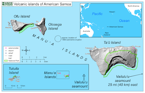 The Manu‘a Islands, located about 60 miles (97 km) east of Tutuila, include Ofu, Olosega and Taʻū. Ofu and Olosega, separated by the narrow Asaga Straight, are the tops of two shield volcanoes. Taʻū, the largest of the Manuʻa group, is a shield volcano with rift zones to the northeast and northwest. In 1866, a submarine eruption formed a cone between Taʻū and Olosega.
The Vailuluʻu seamount, the youngest Samoan volcano, is located about 25 miles (40 km) east of Taʻū. It is a submarine volcano with a summit about 2,000 feet (600 m) below sea level. Vailuluʻu has erupted multiple times over the past 50 years. During the past 20 years, a young cone has grown within the summit caldera.
Based on felt reports and historic activity, Taʻū and Vailuluʻu were identified as likely possible sources for the recent earthquakes. It was initially difficult to confirm the source because, until a few days ago, there were no seismometers close enough to determine the distance to the source of the earthquakes.
The latest data, obtained from rapidly deployed microseismometers, indicate that the source is closer to Taʻū than Olosega and not close to Vailuluʻu. The earthquake swarm is most likely due to magma movement beneath the volcanoes and not tectonic faulting.
HVO became aware of these earthquake reports on Aug. 7. HVO and federal partners—NOAA National Weather Service Office in Pago Pago, NOAA Pacific Tsunami Warning Center, NOAA-IOC International Tsunami Information Center, NPS National Park of American Samoa, NOAA National Marine Sanctuary of American Samoa, and USGS National Earthquake Information Center—are working closely together with American Samoa officials to respond to this evolving situation.
HVO staff traveled to American Samoa on Aug. 11 to consult with federal partners, local officials and residents. They are working with NWS staff and local residents to install volcano-monitoring equipment. Additional HVO scientists and equipment will arrive in American Samoa later this week.
The USGS Alaskan Volcano Observatory and Wellington Volcano Ash Advisory Center are monitoring American Samoa using remote sensing satellite data, which could show thermal anomalies, volcanic plumes, or volcanic gases related to potential volcanic activity.
It is unclear if this unrest will escalate to a volcanic eruption. If an eruption does occur, it will most likely include slow-moving lava flows or low-level explosions that are localized to a small area. Other hazards could include volcanic gases, ground shaking, and local tsunami. An eruption like Hunga Tonga–Hunga Ha'apai in Tonga earlier this year is extremely unlikely as it is a different type of volcano. Volcanoes in Tonga erupt much more explosively than ones in American Samoa and Hawai'i.
HVO would like to acknowledge every agency and every individual person who has contributed to this response. We especially thank Manuʻa island residents for their observations. Mahalo and Fa'afetai!
Read more about the activity on the Taʻū Island USGS website: https://www.usgs.gov/volcanoes/ta-u-island.
Volcanoes in American Samoa are similar to those in Hawai'i, with the Pacific Plate moving to the northwest over the Samoa hotspot and building submarine volcanoes that eventually emerge from the ocean as islands. These islands are the tops of large basaltic shield volcanoes rising over 15,000 feet (4,500 m) from the surrounding seafloor.
The Samoan hotspot is currently centered on Vailuluʻu seamount, which has had several historic eruptions. The Manuʻa Islands of Ofu, Olosega, and Ta‘ū—along with the main island of Tutuila—are all considered potentially active as they have erupted within the last 10,000 years.
Tutuila is the most populous island in American Samoa and is where the capital city of Pago Pago is located. The youngest dated eruption in American Samoa on land is on Tutuila and occurred approximately 1400–1700 years ago. However, numerous submarine eruptions have occurred more recently at volcanoes east of Tutuila.

The Vailuluʻu seamount, the youngest Samoan volcano, is located about 25 miles (40 km) east of Taʻū. It is a submarine volcano with a summit about 2,000 feet (600 m) below sea level. Vailuluʻu has erupted multiple times over the past 50 years. During the past 20 years, a young cone has grown within the summit caldera.
Based on felt reports and historic activity, Taʻū and Vailuluʻu were identified as likely possible sources for the recent earthquakes. It was initially difficult to confirm the source because, until a few days ago, there were no seismometers close enough to determine the distance to the source of the earthquakes.
The latest data, obtained from rapidly deployed microseismometers, indicate that the source is closer to Taʻū than Olosega and not close to Vailuluʻu. The earthquake swarm is most likely due to magma movement beneath the volcanoes and not tectonic faulting.
HVO became aware of these earthquake reports on Aug. 7. HVO and federal partners—NOAA National Weather Service Office in Pago Pago, NOAA Pacific Tsunami Warning Center, NOAA-IOC International Tsunami Information Center, NPS National Park of American Samoa, NOAA National Marine Sanctuary of American Samoa, and USGS National Earthquake Information Center—are working closely together with American Samoa officials to respond to this evolving situation.
HVO staff traveled to American Samoa on Aug. 11 to consult with federal partners, local officials and residents. They are working with NWS staff and local residents to install volcano-monitoring equipment. Additional HVO scientists and equipment will arrive in American Samoa later this week.
The USGS Alaskan Volcano Observatory and Wellington Volcano Ash Advisory Center are monitoring American Samoa using remote sensing satellite data, which could show thermal anomalies, volcanic plumes, or volcanic gases related to potential volcanic activity.
It is unclear if this unrest will escalate to a volcanic eruption. If an eruption does occur, it will most likely include slow-moving lava flows or low-level explosions that are localized to a small area. Other hazards could include volcanic gases, ground shaking, and local tsunami. An eruption like Hunga Tonga–Hunga Ha'apai in Tonga earlier this year is extremely unlikely as it is a different type of volcano. Volcanoes in Tonga erupt much more explosively than ones in American Samoa and Hawai'i.
HVO would like to acknowledge every agency and every individual person who has contributed to this response. We especially thank Manuʻa island residents for their observations. Mahalo and Fa'afetai!
Read more about the activity on the Taʻū Island USGS website: https://www.usgs.gov/volcanoes/ta-u-island.
To read comments, add your own, and like this story, see www.facebook.com/kaucalendar. See latest print edition at wwwkaucalendar.com. See upcoming events at https://kaunewsbriefs.blogspot.com/2022/04/upcoming-events-for-kau-and-volcano.html
 |
| This reference map depicts the ongoing Kīlauea summit eruption on Aug. 18. One eruptive vent (orange) is active within Halema‘uma‘u, on the western side of the crater floor. An adjacent pond (purple) is feeding lava to a larger lake (red) via a crusted-over tube. The eruption statistics provided are from the last HVO overflight on Aug. 16/ This map provides a volume-averaged elevation for the crater floor—2,887 feet (880 meters) above sea level—and its rise since Sept. 29, 2021—449 feet (137 meters). Lava is presently visible from three public visitor overlooks in Hawai‘i Volcanoes National Park: Keanakāko‘i Overlook and Kūpina‘i Pali (Waldron Ledge) where viewers can see the eruptive vent and lava lake, while viewers at Kīlauea Overlook can occasionally see lava ooze-outs in the southeast part of the crater. Visit the park eruption page for more info: https://www.nps.gov/havo/learn/nature/september-2021-eruption.htm. |
HAWAI'I VOLCANIC ACTIVITY UPDATES FROM USGS:
Kīlauea volcano is erupting. Its USGS Volcano Alert level is at WATCH (https://www.usgs.gov/natural-hazards/volcano-hazards/about-alert-levels). Kīlauea updates are issued daily.
Over the past week, lava has continued to erupt from the western vent within Halemaʻumaʻu crater. All lava is confined within Halemaʻumaʻu crater in Hawai‘i Volcanoes National Park. Sulfur dioxide emission rates remain elevated and were last measured at approximately 1,150 tonnes per day on Aug. 12. Seismicity is elevated but stable, with few earthquakes and ongoing volcanic tremor. Over the past week,
summit tiltmeters recorded several deflation-inflation sequences (DI-events). For more information on the current eruption of Kīlauea, see https://www.usgs.gov/volcanoes/kilauea/recent-eruption.
Mauna Loa is not erupting and remains at Volcano Alert Level ADVISORY. This alert level does not mean that an eruption is imminent or that progression to an eruption from the current level of unrest is certain. Mauna Loa updates are issued weekly.
This past week, about 96 small-magnitude earthquakes were recorded below the summit and upper elevation flanks of Mauna Loa—the majority of these occurred at shallow depths less than 15 kilometers (9 miles) below sea level. Global Positioning System (GPS) measurements show low rates of ground deformation over the past week. Gas concentrations and fumarole temperatures at both the summit and at Sulphur Cone on the Southwest Rift Zone have remained stable over the past week. Webcams show no changes to the landscape. For more information on current monitoring of Mauna Loa, see: https://www.usgs.gov/volcanoes/mauna-loa/monitoring.
One earthquake was reported felt in the Hawaiian Islands during the past week: a M3.4 earthquake 7 km (4 mi) E of Pāhala at 34 km (21 mi) depth on August 16 at 4:37 p.m. HST.
HVO continues to closely monitor Kīlauea's ongoing eruption and Mauna Loa for any signs of increased activity.
Visit HVO’s website for past Volcano Watch articles, Kīlauea and Mauna Loa updates, volcano photos, maps, recent earthquake info, and more. Email questions to askHVO@usgs.gov.
Over the past week, lava has continued to erupt from the western vent within Halemaʻumaʻu crater. All lava is confined within Halemaʻumaʻu crater in Hawai‘i Volcanoes National Park. Sulfur dioxide emission rates remain elevated and were last measured at approximately 1,150 tonnes per day on Aug. 12. Seismicity is elevated but stable, with few earthquakes and ongoing volcanic tremor. Over the past week,
 |
| Mauna Loa summit from a Civil Air Patrol plane in 2019. Photo from USGS |
Mauna Loa is not erupting and remains at Volcano Alert Level ADVISORY. This alert level does not mean that an eruption is imminent or that progression to an eruption from the current level of unrest is certain. Mauna Loa updates are issued weekly.
This past week, about 96 small-magnitude earthquakes were recorded below the summit and upper elevation flanks of Mauna Loa—the majority of these occurred at shallow depths less than 15 kilometers (9 miles) below sea level. Global Positioning System (GPS) measurements show low rates of ground deformation over the past week. Gas concentrations and fumarole temperatures at both the summit and at Sulphur Cone on the Southwest Rift Zone have remained stable over the past week. Webcams show no changes to the landscape. For more information on current monitoring of Mauna Loa, see: https://www.usgs.gov/volcanoes/mauna-loa/monitoring.
One earthquake was reported felt in the Hawaiian Islands during the past week: a M3.4 earthquake 7 km (4 mi) E of Pāhala at 34 km (21 mi) depth on August 16 at 4:37 p.m. HST.
HVO continues to closely monitor Kīlauea's ongoing eruption and Mauna Loa for any signs of increased activity.
Visit HVO’s website for past Volcano Watch articles, Kīlauea and Mauna Loa updates, volcano photos, maps, recent earthquake info, and more. Email questions to askHVO@usgs.gov.
To read comments, add your own, and like this story, see www.facebook.com/kaucalendar. See latest print edition at wwwkaucalendar.com. See upcoming events at https://kaunewsbriefs.blogspot.com/2022/04/upcoming-events-for-kau-and-volcano.html
Joy Kono, Executive Director for Farm Services Administration in Hawai'i and the Pacific Basin, said,
 |
| Joy Kono, Executive Director of Farm Services Administration in Hawai'i and Pacific Basin |
The Consolidated Appropriations Act of 2022 reauthorized RTCP and allows farmers and ranchers in Alaska, Hawai'i and insular areas including the Commonwealth of Puerto Rico, Guam, American Samoa, Commonwealth of the Northern Mariana Islands, Virgin Islands of the United States, Federated States of Micronesia, Republic of the Marshall Islands and Republic of Palau, to recover any costs to transport agricultural commodities or inputs used to produce an agricultural commodity. Nearly $2 million was issued to 882 producers through the 2021 Reimbursement Transportation Cost Payment program in May 2022.
RTCP payments are calculated based on the costs incurred for transportation of the agricultural commodity or inputs during a 12-month period, subject to an $8,000 per producer cap per fiscal year once the allocated $3 million has been reached. If total transportation cost for payments exceeds the funds available from the program for a fiscal year, payments will be reduced on a pro-rata basis.
Farmers and ranchers can obtain applications and other documents by calling toll-free 1-866-794-1079 or by contacting FSA at the local USDA Service Center.

To read comments, add your own, and like this story, see www.facebook.com/kaucalendar. See latest print edition at wwwkaucalendar.com. See upcoming events at https://kaunewsbriefs.blogspot.com/2022/04/upcoming-events-for-kau-and-volcano.html


-1-1-2.jpg)
