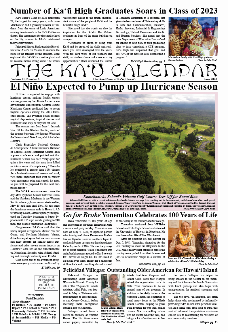
 |
| Gov. Josh Green signed gun safety bills into law on National Gun Awareness Day. Photo from Gov. Green |
JUNE IS GUN VIOLENCE AWARENESS MONTH WITH FRIDAY, NATIONAL GUN VIOLENCE AWARENESS DAY. On this day, Gov. Josh Green signed into law two new gun bills for Hawai'i. He said signing of SB1230 and HB1239 is critical, "as gun violence represents an urgent public health and public safety issue. These bills strike a very appropriate balance between public safety, and protecting people and children in Hawaiʻi, along with respecting the Second Amendment right of individuals." He said both measures will help "to preserve the safety of Hawai'i residents, visitors, and keiki."
The Governor noted that despite Hawai'i remaining the second lowest state for gun violence in the country, recent nationwide data shows that Hawai'i had the greatest one-year increase in gun violence (43 percent) from 2020 to 2021. In an average year, 61 people die by guns in Hawai'i. About 60 percent are suicides.

Green also noted that SB 1230 was prepared in response to the U.S. Supreme Court's Bruen decision, which required that law-abiding individuals generally be allowed to carry weapons in public as a matter of constitutional Second Amendment law. "The new state law is intended to mitigate the harm arising from the Supreme Court decision, in accordance with the U.S. Constitution. Act 53 (HB1329) will provide active shooter training in public and charter schools statewide."
HB1329, Related to Education (Active Shooter Training) requires the Department of Education to work with certain organizations to develop and implement an active shooter training program in all public and charter schools. It also allows public and charter school students to decline to participate in active shooter training.
"I never could have imagined a world in which our keiki would need to have active shooter training in school," said Green. "But given the very real threat, I firmly believe in providing this potentially life-saving education for our public and charter school students, to help make sure they get to go home to their families."
Act 52 (SB1230) addresses sensitive places where firearms are prohibited. The purpose is to create a statewide policy that will help to avoid confusion from county to county throughout the state.  |
| Hawai'i Island state House member and Chair of Judiciary David Tarnas said new gun measures protect Second Amendment rights while balancing need to maintain safe and protected spaces. Photo from Governor Green |
The language of SB1230, Relating to Firearms: "Prohibits firearms in certain locations and premises.
Requires possession and disclosure of a license to carry. Prohibits leaving an unsecured firearm in a vehicle unattended. Prohibits consuming or being under the influence of alcohol, an intoxicating liquor, or a controlled substance when carrying a firearm. Prohibits carrying or possessing firearms on certain private property without express authorization. Requires annual reports from the department of the attorney general on carry licenses. Amends the requirements for, and revocation of, firearms permits and licenses. Amends the disqualification of persons from owning, possessing, or controlling a firearm. Expands the qualified immunity for health care providers who provide information on firearms applicants to include physician assistants and advanced practice registered nurses."
First Deputy Solicitor General Nick McLean, of the Office of the Attorney General, said, "This important legislation will help reduce the risks of gun violence in our communities by establishing reasonable safeguards. The law protects the public by putting in place common-sense training and education requirements, as well as protections for sensitive locations like schools, parks, and playgrounds."
Vice President of the state Senate, Michelle Kidani, said, "On National Gun Violence Awareness Day, we honor the survivors and those we have lost to gun violence, and we trust that common-sense gun violence prevention measures like House Bill 1329 will help keep Hawaiʻi safe for our neighbors and prevent future tragedies. With the signing of these bills into law, Hawaiʻi remains a national leader in gun violence prevention."
State House Judiciary and Hawaiian Affairs Chair David Tarnas said, "SB1230 was carefully crafted to ensure that it is consistent with the Court's interpretation of the Second Amendment, and allows for the establishment of a fair system of regulation for concealed carry. We aimed to create a balanced approach that respects the rights of gun owners and the need to maintain safe and protected spaces in Hawaiʻi. Additionally, HB1329 takes into consideration the importance of equipping our teachers and students with the critical knowledge and skills to respond to emergencies. Together, we can continue to protect lives and create safer communities for our families."
Chris Marvin, of the Everytown for Gun Safety Veteran Advisory Council, said, "Hawai'i is currently one of the safest states in the nation with the second lowest rate of gun violence. This is not due to chance. We're safer because of sound public policy, and we must do everything we can to keep it that way and to protect our 'ohana and our people.
SHAWNA TIDWELL OF OCEAN VIEW IS WANTED FOR WARRANTS AND QUESTIONING FOR CRIMINAL INVESTIGATIONS. Hawai‘i Island police are requesting the public’s assistance in locating the 40-year old. Known to frequent the Kona and Ka‘ū areas, Tidwell is described as 5 feet 1 inch tall, 118 pounds, with dyed red hair and blue eyes. Hawaii Police Department sent out a statement reminding the public that harboring or concealing a wanted person could result in criminal charges.
Anyone with information on Tidwell’s whereabouts is encouraged to contact Detective Donovan Kohara at (808) 960-3118; or via email at donovan.kohara@hawaiicounty.gov. Also contact the police department’s non-emergency number at (808) 935-3311. Citizens who wish to remain anonymous can make a through Crime Stoppers at (808) 961-8300 and be eligible for a reward of up to $1,000. Crime Stoppers does not record any calls or subscribe to caller ID.
In a recent Volcano Watch article, we learned about a remote sensing technique known as InSAR. This method of using satellite radar signals to detect changes to the surface of the earth has been very beneficial for monitoring of active volcanoes, especially in remote locations where it is difficult to install ground based geophysical sensors.

One such place where InSAR recently proved instrumental in detecting deformation of a volcano previously considered inactive was in Southeast Alaska.
On April 11, 2022, Alaska Volcano Observatory scientists observed seismic activity at Mount Edgecumbe on Kruzof Island near the town of Sitka, Alaska. Except for an elaborate April Fool’s Day prank in 1974, this volcano has remained quiet for around 4,000 years based on its geologic record.
Oral history of the local Tlingit recently handed down by Herman Kitka reports “a mountain blinking, spouting fire and smoke,” which perhaps describes a small fire fountaining eruption. This is possible as recent as 800-900 years ago; however, the timing of this oral history is uncertain.
Shallow, small earthquakes detected in April 2022 were broadly distributed to the northeast of the summit. This activity initiated a response by AVO scientists to try to understand the source of the earthquakes. Unfortunately, this volcano had no existing local ground-based geophysical instruments; the larger earthquakes described above were detected on distant seismographs of the regional seismic network used by the Alaska Earthquake Center to monitor tectonic activity. No seismographs or geodetic instrumentation existed close to the volcanic edifice that would be useful in detecting and interpreting subsurface activity of the volcano!
With no ground-based instruments installed near the volcano, satellite remote sensing techniques were used to investigate potential changes. An InSAR time series was utilized to search for surficial changes at Mount Edgecumbe. AVO scientists used sequential unwrapped interferograms to create a time series of change from several years of interferograms. Creating an InSAR time series allowed them to produce a cumulative displacement map, as shown in the image accompanying this article, where each colored pixel represents the total deformation at that location over the 7 years of this retrospective study. The results successfully identified deformation that started long before the recent earthquake swarm. Retrospective analysis of seismicity at the nearest seismograph in Sitka showed an increase in low-magnitude seismic activity in mid-2019.

An influx of magma into a volcanic edifice such as this does not indicate the potential of an eruption. This merely is the indication that there is some magmatic activity at depth. Scientists expect more changes in deformation, higher rates of seismicity, and detection of volcanic gases prior to any eruption at Mount Edgecumbe. This summer, AVO will install further instrumentation and conduct gas and geologic studies at Mount Edgecumbe, in addition to continued InSAR and seismic analyses, allowing scientists at the Alaska Volcano Observatory to better monitor this volcano for such changes. To learn more, see the recent publication detailing this study from AVO scientists.
Volcano Activity Updates:
Kīlauea is not erupting. Its USGS Volcano Alert level is ADVISORY. Webcams show no signs of active lava in Halemaʻumaʻu crater, at the summit of Kīlauea in Hawai‘i Volcanoes National Park. Over the past week, summit tiltmeters showed inflation and seismicity remains elevated beneath Kīlauea summit and Nāmakanipaio. The summit sulfur dioxide (SO2) emission rate was most recently measured on May 26, when it totaled 120 tonnes per day.
Requires possession and disclosure of a license to carry. Prohibits leaving an unsecured firearm in a vehicle unattended. Prohibits consuming or being under the influence of alcohol, an intoxicating liquor, or a controlled substance when carrying a firearm. Prohibits carrying or possessing firearms on certain private property without express authorization. Requires annual reports from the department of the attorney general on carry licenses. Amends the requirements for, and revocation of, firearms permits and licenses. Amends the disqualification of persons from owning, possessing, or controlling a firearm. Expands the qualified immunity for health care providers who provide information on firearms applicants to include physician assistants and advanced practice registered nurses."
First Deputy Solicitor General Nick McLean, of the Office of the Attorney General, said, "This important legislation will help reduce the risks of gun violence in our communities by establishing reasonable safeguards. The law protects the public by putting in place common-sense training and education requirements, as well as protections for sensitive locations like schools, parks, and playgrounds."
Vice President of the state Senate, Michelle Kidani, said, "On National Gun Violence Awareness Day,

State House Judiciary and Hawaiian Affairs Chair David Tarnas said, "SB1230 was carefully crafted to ensure that it is consistent with the Court's interpretation of the Second Amendment, and allows for the establishment of a fair system of regulation for concealed carry. We aimed to create a balanced approach that respects the rights of gun owners and the need to maintain safe and protected spaces in Hawaiʻi. Additionally, HB1329 takes into consideration the importance of equipping our teachers and students with the critical knowledge and skills to respond to emergencies. Together, we can continue to protect lives and create safer communities for our families."
Chris Marvin, of the Everytown for Gun Safety Veteran Advisory Council, said, "Hawai'i is currently one of the safest states in the nation with the second lowest rate of gun violence. This is not due to chance. We're safer because of sound public policy, and we must do everything we can to keep it that way and to protect our 'ohana and our people.
To read comments, add your own, and like this story, see facebook.com/kaucalendar. See latest print edition at kaucalendar.com, in the mail and on stands.
 |
| Shawna Tidwell |
Anyone with information on Tidwell’s whereabouts is encouraged to contact Detective Donovan Kohara at (808) 960-3118; or via email at donovan.kohara@hawaiicounty.gov. Also contact the police department’s non-emergency number at (808) 935-3311. Citizens who wish to remain anonymous can make a through Crime Stoppers at (808) 961-8300 and be eligible for a reward of up to $1,000. Crime Stoppers does not record any calls or subscribe to caller ID.
To read comments, add your own, and like this story, see facebook.com/kaucalendar. See latest print edition at kaucalendar.com, in the mail and on stands.
VOLCANO MONITORING FROM SPACE is the subject of this week's Volcano Watch, written by Hawaiian Volcano Observatory deformation technician Logan Fuso:In a recent Volcano Watch article, we learned about a remote sensing technique known as InSAR. This method of using satellite radar signals to detect changes to the surface of the earth has been very beneficial for monitoring of active volcanoes, especially in remote locations where it is difficult to install ground based geophysical sensors.
Aerial view of Mount Edgecumbe crater taken on May 19, 2022. Mount Edgecumbe is a volcano in Southeast Alaska,
near Sitka. Image courtesy of Max Kaufman, AVO/UAF-GI.
One such place where InSAR recently proved instrumental in detecting deformation of a volcano previously considered inactive was in Southeast Alaska.
On April 11, 2022, Alaska Volcano Observatory scientists observed seismic activity at Mount Edgecumbe on Kruzof Island near the town of Sitka, Alaska. Except for an elaborate April Fool’s Day prank in 1974, this volcano has remained quiet for around 4,000 years based on its geologic record.
Oral history of the local Tlingit recently handed down by Herman Kitka reports “a mountain blinking, spouting fire and smoke,” which perhaps describes a small fire fountaining eruption. This is possible as recent as 800-900 years ago; however, the timing of this oral history is uncertain.
Shallow, small earthquakes detected in April 2022 were broadly distributed to the northeast of the summit. This activity initiated a response by AVO scientists to try to understand the source of the earthquakes. Unfortunately, this volcano had no existing local ground-based geophysical instruments; the larger earthquakes described above were detected on distant seismographs of the regional seismic network used by the Alaska Earthquake Center to monitor tectonic activity. No seismographs or geodetic instrumentation existed close to the volcanic edifice that would be useful in detecting and interpreting subsurface activity of the volcano!
With no ground-based instruments installed near the volcano, satellite remote sensing techniques were used to investigate potential changes. An InSAR time series was utilized to search for surficial changes at Mount Edgecumbe. AVO scientists used sequential unwrapped interferograms to create a time series of change from several years of interferograms. Creating an InSAR time series allowed them to produce a cumulative displacement map, as shown in the image accompanying this article, where each colored pixel represents the total deformation at that location over the 7 years of this retrospective study. The results successfully identified deformation that started long before the recent earthquake swarm. Retrospective analysis of seismicity at the nearest seismograph in Sitka showed an increase in low-magnitude seismic activity in mid-2019.
Sentinel-1 SAR satellite data analyzed with the Alaska Satellite Facility's Hyp3 was used to create a time series of change over Kruzof Island for August 2018 through April 15, 2023. Deformation rates increased closer to the northeast flanks of Mount Edgecumbe from this dataset, with inflation rates as high as 4 inches (10.4 cm) per year in the line-of-sight direction. Top-right inset shows earthquakes located under Kruzof Island (locations by Alaska Earthquake Center, retrieved through USGS comcat) between 2010 and April 2023. Earthquakes that can be located by the regional network start in 2020 (marked in blue). The earthquakes shown in red are all part of the 2022 swarm of activity. Image courtesy of Ronni Grapenthin & Yitian Cheng, AVO/UAF-GI
Each colored pixel in these results represents the total movement of a patch of ground approximately 100 square feet (20-30 square meters) for this InSAR time series. The displacement data of a selected pixel, plotted on the lower right side of the image, has shown that steady inflation started sometime in August 2018, several years prior to the earthquake activity observed in April 2022. Steady inflation has continued since 2018. Results of this analysis prompted the Alaska Volcano Observatory to start the next phase of monitoring on Mount Edgecumbe. In the summer of 2022, a seismic and GNSS station (Global Navigation Satellite System, which includes GPS) station was installed near the volcano for active monitoring. The GNSS instrument gives a more precise 3-dimensional deformation estimate for the volcanic edifice, without the need to have to wait for a SAR satellite repeat visit (about 12 days). Together, GNSS and InSAR can give a very clear picture of magmatic processes, without having to be anywhere near the volcano for extended periods except a brief installation period!An influx of magma into a volcanic edifice such as this does not indicate the potential of an eruption. This merely is the indication that there is some magmatic activity at depth. Scientists expect more changes in deformation, higher rates of seismicity, and detection of volcanic gases prior to any eruption at Mount Edgecumbe. This summer, AVO will install further instrumentation and conduct gas and geologic studies at Mount Edgecumbe, in addition to continued InSAR and seismic analyses, allowing scientists at the Alaska Volcano Observatory to better monitor this volcano for such changes. To learn more, see the recent publication detailing this study from AVO scientists.
Volcano Activity Updates:
Kīlauea is not erupting. Its USGS Volcano Alert level is ADVISORY. Webcams show no signs of active lava in Halemaʻumaʻu crater, at the summit of Kīlauea in Hawai‘i Volcanoes National Park. Over the past week, summit tiltmeters showed inflation and seismicity remains elevated beneath Kīlauea summit and Nāmakanipaio. The summit sulfur dioxide (SO2) emission rate was most recently measured on May 26, when it totaled 120 tonnes per day.
Mauna Loa is not erupting. Its USGS Volcano Alert Level is at NORMAL.
Webcams show no signs of activity on Mauna Loa. Seismicity remains low. Summit ground deformation rates show inflation above background levels, but this is not uncommon following eruptions. SO2 emission rates are at background levels.
There were two earthquakes with 3 or more felt reports in the Hawaiian Islands during the week ending Wednesday and a M2.6 earthquake 1 km (0 mi) WSW of Captain Cook at 8 km (5 mi) depth on May 29 at 9:34 p.m. HST and a M3.2 earthquake 4 km (2 mi) SSW of Pāhala at 31 km (19 mi) depth on May 27 at 5:42 p.m. HST.
HVO continues to closely monitor Kīlauea and Mauna Loa.
Visit HVO’s website for past Volcano Watch articles, Kīlauea and Mauna Loa updates, volcano photos, maps, recent earthquake information, and more. Email questions to askHVO@usgs.gov.
Visit HVO’s website for past Volcano Watch articles, Kīlauea and Mauna Loa updates, volcano photos, maps, recent earthquake information, and more. Email questions to askHVO@usgs.gov.
To read comments, add your own, and like this story, see facebook.com/kaucalendar. See latest print edition at kaucalendar.com, in the mail and on stands.

.jpg)


-1.jpg)


