About The Kaʻū Calendar

Saturday, June 08, 2024

Kaʻū News Briefs June 7, 2024

In addition to elevated volcanic gas emissions, other significant hazards also remain around the recent eruption site on the upper Southwest Rift Zone of Kīlauea. Minor to severe ground fractures and subsidence features that formed during the June 3 eruption may continue to widen and offset, may have unstable overhanging edges, and should be avoided, warns USGS. Most cracks that formed during the June 3 Kīlauea Southwest Rift Zone eruption are several inches (2 to 5 centimeters) wide with some extending to up to 6.5 feet (2 meters) wide. In this photo, a crack extends towards Pu'ukoa'e in the background. USGS Photo by A.R. Nalesnik
WITH ERUPTION HALTED, MORE AREAS IN HAWAI'I VOLCANOES NATIONAL PARK reopen, but Maunaiki and Kaʻū Desert trails remain closed.
    Kīlauea volcano is not erupting. Hilina Pali Road, Kulanaokuaiki Campground, the Footprints Exhibit and Pepeiao Cabin in Hawai'i Volcanoes National Park are now open.
    In addition, the park reopened the coastal campsite at Kaʻaha, Devastation Trail and Keanakākoʻi earlier this week. The areas were closed after the June 3 fissure eruption began near the volcano's remote upper Southwest Rift Zone.
    Maunaiki Trail and Kaʻū Desert Trail past the Footprints Exhibit remain closed due to elevated gases and other volcanic hazards that remain at the eruption site. Visitors should plan ahead and check the park website for updates before entering the park.
    Scientists with the U.S. Geological Survey Hawaiian Volcano Observatory (USGS HVO) reported elevated volcanic gas emissions, ground subsidence and severe earth cracks that formed during the short-lived eruption. These cracks have unstable edges and could continue to widen.
    Other hazards include hot, glass-like surfaces on the new lava flows, uneven and rough terrain and hot temperatures.
    The fissure eruption started on Monday, June 3 around 12:30 a.m. in a remote area in Hawaiʻi Volcanoes National Park, about about 2.5 miles (4 km) southwest of Kīlauea caldera near the volcano's upper Southwest Rift Zone. The area is in the Ka'u Desert between Pahala and Volcano.

To read comments, add your own, and like this story, see facebook.com/kaucalendar. See upcoming events, print edition and archive at kaunews.com. Support this news service with advertising at kaunews.com. 7,500 copies in the mail and on stands.

KAʻŪ COFFEE FESTIVAL WRAPS UP SATURDAY AT PĀHALA COMMUNITY CENTER, followed by an Afterparty at Mauka to Makai Eatery on Manadina Farm, on the mountain road between Pāhala and Nāʻālehu. Indulge in farm-to-table cuisine with ingredients that directly support Kaʻū agriculture, and enjoy some Kaʻū Coffee as the festival comes to an end. Groove to art and live music from talented local bands, all set against the backdrop of panoramic views of Mauna Loa, and the Kaʻū Coast. Suggested Donation: $20 to support local musicians. For more details, visit www.manadina.com/dining. The organizers call the Afterparty a "celebration of Kaʻū's vibrant culture and agriculture."
A hayride on the Coffee & Cattle Day farm and ranch at Aikane Plantation on Friday, during the Kaʻū Coffee Festival.
Photo by Ophir Danenberg

The first Coffee & Cattle Day at Aikane Plantation comes with the first Kaʻū Coffee Festival since 2019. The week wraps up on Saturday from 9 a.m. to 5 p.m. at the Ho'olaulea. Photo by Ophir Danenberg

Friday's Coffee & Cattle Day at Aikane Plantation led up to Stargazing Friday night above Kaʻū Coffee Mill and the Saturday Ho'olaulea finale of Kaʻū Coffee Festival 2024 at Pāhala Community Center. Photo by Ophir Danenberg

Horses meet the people at Aikane Plantation Coffee & Cattle Day on Friday as part of Kaʻū Coffee Festival. It wraps up Saturday with the 9 a.m. to 5 p.m. Ho'olaulea with meeting the farmers and tasting their coffee, food, crafts, music and hula at Pāhala Community Center. Meet Merle and Phil Becker, of Aikane Plantation, at the welcome table. Photo by Ophir Danenberg
To read comments, add your own, and like this story, see facebook.com/kaucalendar. See upcoming events, print edition and archive at kaunews.com. Support this news service with advertising at kaunews.com. 7,500 copies in the mail and on stands.

KAHUKU UNIT OF HAWAI'I VOLCANOES NATIONAL PARK WILL HAVE A BOOTH AT KA'U COFFEE FESTIVAL ON SATURDAY. Rangers will share that the 40th Hawaiʻi Volcanoes National Park Hawaiian Cultural Festival will be in Kahuku on Saturday, July 20 from 10 a.m. to 3 p.m.
    This free event features musicians, hula performances and Hawaiian arts and craft practitioners. Local conservation groups, Hawaiian games and food for purchase (or bring your own picnic) will also be on hand. Bring water, sun protection, and a rain jacket; a hat, a ground mat or chair are recommended. This is a  family-friendly experience: e komo mai. A complete entertainment line up is coming soon.


    At this Saturday's information/education booth at Kaʻū Coffee Festival at the Pahala Community Center, attendees are invited to play kōnane or wili a ti leaf lei.
    On June 15 at 9:30 Kuhuku offers a Coffee Talk featuring award-winning writer and novelist Leah Newsom. She is the National Parks Arts Foundation's June 2024 artist in residence and will bring her extensive literary background and passion for environmental storytelling to Kahuku.
    On June 29th rangers from Kahuku and Kīlauea will march in the Nāʻālehu 4th of July parade. Parade will start from Nāʻālehu Elementary School and go down Mamalahoa Highway to the Hongwanji temple. There will also be a hoʻolauleʻa afterwards at the OKK farmers market grounds.
    Thursday through Sunday, 8-4, there are eight hiking trails, picnic spots, and panoramic views open to the public.


Thursday, June 06, 2024

Kaʻū News Briefs June 6, 2024

Thin pahoehoe lava from the 12 eruption this week. USGS photo

THE VOLCANIC ERUPTION THIS WEEK WILL LIKELY NOT RESTART, according to USGS Hawaiian Volcano Observatory. HVO reported on Thursday that there is tremor, degassing and incandescence involving the fissure vents in the Kīlauea Southwest Rift Zone. However, the activity has decreased since the 12 hour eruption on June 3, "making it unlikely that this eruption will restart. Volcanic gas emissions at the eruption site remain above background levels. Overall seismicity in the summit region including the eruption area remains low. Inflationary ground deformation of the summit continues. Although the eruption has paused, additional pulses of seismicity and deformation could result in new eruptive episodes within the area or elsewhere on the Southwest Rift Zone." The degassing has brought vog across Kaʻū and a decrease in air quality.

To read comments, add your own, and like this story, see facebook.com/kaucalendar. See upcoming events, print edition and archive at kaunews.com. Support this news service with advertising at kaunews.com. 7,500 copies in the mail and on stands.

Four periods of earthquake activity showing two distinct clusters. USGS images
TWO DISTINCT CLUSTERS OF EARTHQUAKES shook Kīlauea during four recent time periods of swarm activity, as shown by USGS Hawaiian Volcano Observatory's illustration released on Thursday. "The event counts at the south caldera cluster increase while the counts at the upper East Rift Zone cluster diminish from the first to the fourth time periods," from April 217 to the eruption on June 3, reports USGS.

To read comments, add your own, and like this story, see facebook.com/kaucalendar. See upcoming events, print edition and archive at kaunews.com. Support this news service with advertising at kaunews.com. 7,500 copies in the mail and on stands.

KEEPING. UP WITH KILAUEA is the title of this week's Volcano Watch, a weekly article and activity update written by U.S. Geological Survey Hawaiian Volcano Observatory scientists and affiliates. The following article was written by Research Corporation of the University of Hawai'i seismic analyst Maddie Hawk:
    Kīlauea began erupting from fissures southwest of Kaluapele (the summit caldera) just after midnight on June 3; the eruption ceased just nine hours later, though lava flows continued to slowly spread for several more hours. Prior to the brief eruption, the USGS Hawaiian Volcano Observatory (HVO) had been monitoring pulses of heightened seismic activity in the summit area for weeks.
    How did these earthquakes give us insight into the features of the molten magma below and the eruption that was to come?
    Earthquakes result from the breaking of cooler, brittle rock. As magma moves into an area, it forces the surrounding rock to bend and then break. This brittle rock "failure" is what seismologists at HVO see daily on live data streams as earthquakes. The locations of earthquakes can outline magma chambers, indicate fault movement, or show where magma is moving into new area. At Kīlauea, earthquake swarms paired with changes in ground motion as seen on tiltmeters give HVO scientists an idea of the pressurization of magma chambers beneath the surface.
    The proposed magma plumbing system at Kīlauea is divided into three main chambers: the Halemaʻumaʻu reservoir, the south caldera reservoir, and the Keanakākoʻi reservoir. In the weeks leading up to Monday's eruption, there were three distinct periods of heightened unrest. From April 27–May 3, May 6–9, and May 17–18, two distinct clusters of earthquakes occurred in the south caldera and the upper East Rift Zone (see box 3 in Figure 1).
    During these swarms, earthquake locations often switched between the south caldera cluster and the upper East Rift Zone cluster as magma pressure levels fluctuated within the different storage regions. The event counts at the south caldera cluster increase while the counts at the upper east rift cluster diminish as the system moved closer to eruption. Rates of ground tilt, measured by summit tiltmeters would also increase during the earthquake swarms, indicating an increased pulse of magma was accumulating beneath the surface.
    Although the earthquakes occurred in distinct clusters, they could have happened in response to the stresses created by magma chambers located nearby. For this reason, there were several possibilities scenarios. First, magma accumulation could stop, and no eruption would occur. Magma accumulation could continue with an eruption in Kaluapele or magma could migrate to the southwest with either an intrusion (similar to last January) or eruption.
    As we now know, magma did indeed migrate to the southwest and this time it erupted.

Aerial image of the Southwest Rift Zone eruption of Kīlauea, viewed during an overflight at approximately 6 a.m. on June 3, 2024. USGS image

    Just after noon on Sunday, June 2, earthquakes increased again beneath the south caldera region and intensified quickly, prompting HVO to raise the alert level and aviation color code for Kīlauea at 5:30 p.m. HST.
    For twelve hours, earthquakes of up to M4.1 shook the summit region until 12:30 a.m. Monday morning, when a fissure opened about 1 mile (2 km) southwest of the caldera. The eruption happened in
the vicinity of ground cracks that formed in the late January intrusion.
    Past eruptions in this area—in 1971 and 1974—have been brief, so it was no surprise when the fissure stopped erupting nine hours after the eruption began. Fortunately, the short-lived eruption occurred within a closed area of Hawaiʻi Volcanoes National Park; it did no damage to infrastructure. This was the first eruption in this area of Kīlauea in 50 years, and the first eruption outside of Kaluapele since 2018. Only 
about 100 acres were covered with new lava, compared to over 500 during the September 2023 eruption within Kaluapele.
    While lava has stopped moving on the surface of Kīlauea, volcanic gas emissions remain elevated and activity beneath the surface remains dynamic. HVO scientists will continue to closely monitor for signs of change.

Volcano Activity Updates
    Kīlauea is not erupting. Its USGS Volcano Alert level is ADVISORY.
    Kīlauea erupted briefly on Monday, June 3, southwest of Kaluapele (Kīlauea caldera) within the closed area of Hawai'i Volcanoes National Park. Tremor and incandescence associated with the fissure vents are still present but have decreased significantly since June 3. Sulfur dioxide emission rates remain elevated in the upper Southwest Rift Zone eruption area; an emission rate of 400 tonnes per day was measured today, June 6, for the combined areas of Kīlauea summit and the recent eruption. Overall seismicity in the summit region including the eruption area remains low, although inflationary ground deformation of the summit continues. Additional pulses of seismicity and deformation could result in new eruptive episodes within the area or elsewhere on the Southwest Rift Zone.
    Mauna Loa is not erupting. Its USGS Volcano Alert Level is at NORMAL.
    Webcams show no signs of activity on Mauna Loa. Summit seismicity has remained at low levels over the past month. Ground deformation indicates continuing slow inflation as magma replenishes the reservoir system following the 2022 eruption. SO2 emission rates are at background levels.
    Nine earthquakes were reported felt in the Hawaiian Islands during the past week: a M3.5 earthquake 4 km (2 mi) S of Pāhala at 30 km (18 mi) depth on June 5 at 4:18 a.m. HST, a M3.1 earthquake 3 km (1 mi) SSW of Pāhala at 31 km (19 mi) depth on June 3 at 7:01 a.m. HST, a M4.1 earthquake 7 km (4 mi) SSW of Volcano at 0 km (0 mi) depth on June 2 at 9:12 p.m. HST, a M3.2 earthquake 7 km (4 mi) SW of Volcano at 1 km (1 mi) depth on June 2 at 7:38 p.m. HST, a M4.0 earthquake 7 km (4 mi) SSW of Volcano at 0 km (0 mi) depth on June 2 at 7:06 p.m. HST, a M3.1 earthquake 7 km (4 mi) SSW of Volcano at 0 km (0 mi) depth on June 2 at 6:15 p.m. HST, a M3.4 earthquake 7 km (4 mi) SW of Volcano at 1 km (1 mi) depth on June 2 at 5:15 p.m. HST, a M3.1 earthquake 8 km (4 mi) SW of Volcano at 1 km (0 mi) depth on June 2, 2024 at 4:58 p.m. HST, and a M3.4 earthquake 12 km (7 mi) S of Waikoloa at 35 km (22 mi) depth on June 1 at 7:16 p.m. HST.
    HVO continues to closely monitor Kīlauea and Mauna Loa.


Wednesday, June 05, 2024

Kaʻū News Briefs June 5, 2024

Matt Baker and Vance Bjorn, of Silicon Valley Coffee, hear the history of R&G Coffee and the evolution of Kaʻū Coffee after sugar plantation days, as they visit with Bong Aquino, who farms 27 acres, mostly by himself. Photo by Julia Neal

KA'U COFFEE FARMS OPENED UP TO VISITORS ON WEDNESDAY, with growers sharing their stories of creating their successful enterprises and coming from many different backgrounds. Bong Aquino came out of agriculture in Kaʻū and remembered the days of the sugar plantation shutting down. He and
The Kudos on the former Bull Kailiawa
farm in Cloud Rest. Photo by Julia Neal
Gloria Camba created R&G Farms and Aquino takes care of their 27 acres, mostly by himself, hiring help for picking and some pruning. He told visitors that he has a good life working on the quiet farm in Pear Tree, with the extraordinary mountain and ocean views, among rows of Norfolk pines, banana and palm trees. 
    He said he has rejected offers to sell his Ka'u Coffee
 to Kona and wants to protect the Kaʻū Coffee brand.
     Kaʻū Coffee grower Ray Kudo talked about growing up in Pahala and leaving for a long time to build a career as an executive with ABC stores. He and his wife Norma both worked there, with Ray running the stores in Kona and the Island of Kaua'i. After their retirement, they couldn't keep still and decided to shift to an entire new way of life. They bought the former farm of the late Kaʻū Coffee grower Bull Kailiawa and built a small house on the property. Their acreage at Cloud Rest sits under the mountain peak. They said they love the peace and quiet and enjoy the steady work maintaining their farm.
    They also own a condo on Ali'i Drive in Kona but say that 90 percent of their time is spent in the quiet countryside where they grow not only coffee but a good deal of fresh vegetables for themselves and their friends. Ray Kudo's daughter recently graduated from Harvard University.


Pops from A Farm along the old sugar cane road between Pahala and  Na'alehu visits other Kaʻū Coffee farms to celebrate 
their success during Kaʻū Coffee Festival Week. Photo by Julia Neal


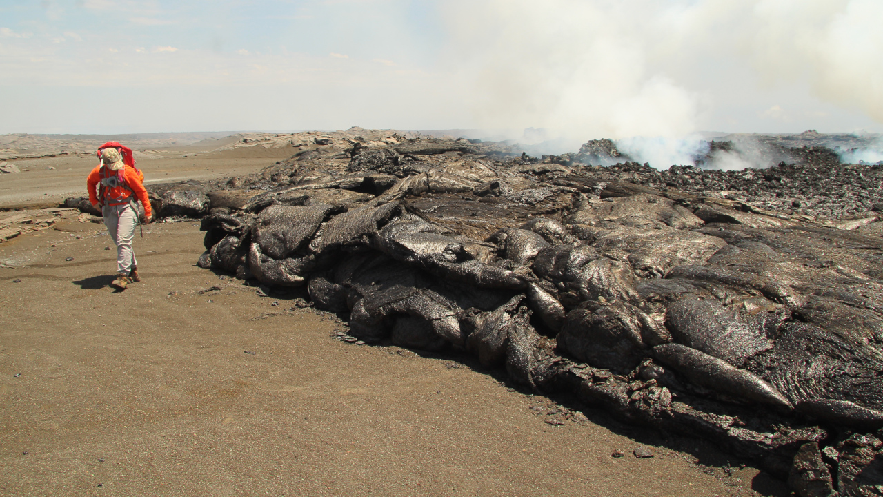
THE SOUTHWEST RIFT ZONE ERUPTION REMAINED PAUSED ON WEDNESDAY. On Tuesday, Hawaiian Volcano Observatory geologists visited the area to take measurements of the previous day's lava flows. They examined part of the lava flow from fissure 2. Note that none of the lava flow is as tall as the geologist; similar to the December 1974 eruption from the same area on Kīlauea, the eruption of June 3 produced extremely thin Pāhoehoe flows. This contrasts with other recent eruptions like that at Pu‘u‘ō‘ō on Kīlauea's East Rift Zone between 1983 and 2018, where Pāhoehoe flows sometimes inflated to tens of meters in thickness. M. Zoeller of USGS Hawaiian Volcano Observatory took this photo.


KA'U DESERT REMAINS CLOSED TO VISITORS FOLLOWING THIS WEEK'S VOLCANIC ERUPTION. Hawai'i Volcanoes National Park reported Wednesday that Kaʻaha has reopened and is accessible by Puna Coast Trail.
    Kaʻū Desert area remains temporarily closed due to volcanic gases from Kīlauea that are hazardous to everyone. Closures include Kaʻū Desert, Footprints, Hilina Pali Road, Kulanaokuaiki Campground, Pepeiao Cabin and Maunaiki Trail.
    Although the eruption that started Monday is over for now, the vent is still glowing and degassing. The eruption covered about 88 acres in this remote area, located 2.5 miles southwest of Kīlauea caldera. Steady plumes of gas were seen Wednesday morning, wafting upward and downwind of the fissures.
     According to USGS, unrest remains high. Tremor is still present, glow could still be seen from the fissures over Tuesday night, with active degassing of SO2 (sulfur dioxide) still occurring. Changes in the character and location of unrest can occur quickly, as can the potential for the eruption to restart at the same fissures or in a new area, reported Hawai'i Volcanoes National Park.

Plumes of volcanic gas are expelled from a vent and drift skyward and laterally along a ground fissure. Image taken
 from Uēkahuna overlook west. NPS Photo by S. Stucker