About The Kaʻū Calendar

Saturday, January 18, 2025

Kaʻū News Briefs Jan. 18, 2025

May be an image of 3 people and fire
 Keanakākoʻi viewing area pre-dawn on Friday, Jan. 17. Park visitors are silhouetted as they watch side-by-side volcanic cones eject fountains of hot orange lava and plumes of gas and water vapor. Photo by Janice Wei

EPISODE FOUR OF THE CURRENT ERUPTION OF Kīlauea ended at 10 a.m. on Saturday. Hawai'i Volcanoes National Park described the displays as "awe-some with dual fountains feeding a large lava lake at the summit," and noted that "this activity could pause, end or decrease at any time." The eruption began on Dec. 23.
    The glow remained at the crater Saturday evening but the fountaining was gone. USGS reported that pele's hair formed in earlier stages of Episode 4 may continue to be remobilized by winds within the park and in nearby communities over the next few days.
    See and learn more at: https://www.nps.gov/havo/planyourvisit/eruption-viewing.htm

To read comments, add your own, and like this story, see facebook.com/kaucalendar. See upcoming events, print edition and archive at kaunews.com.

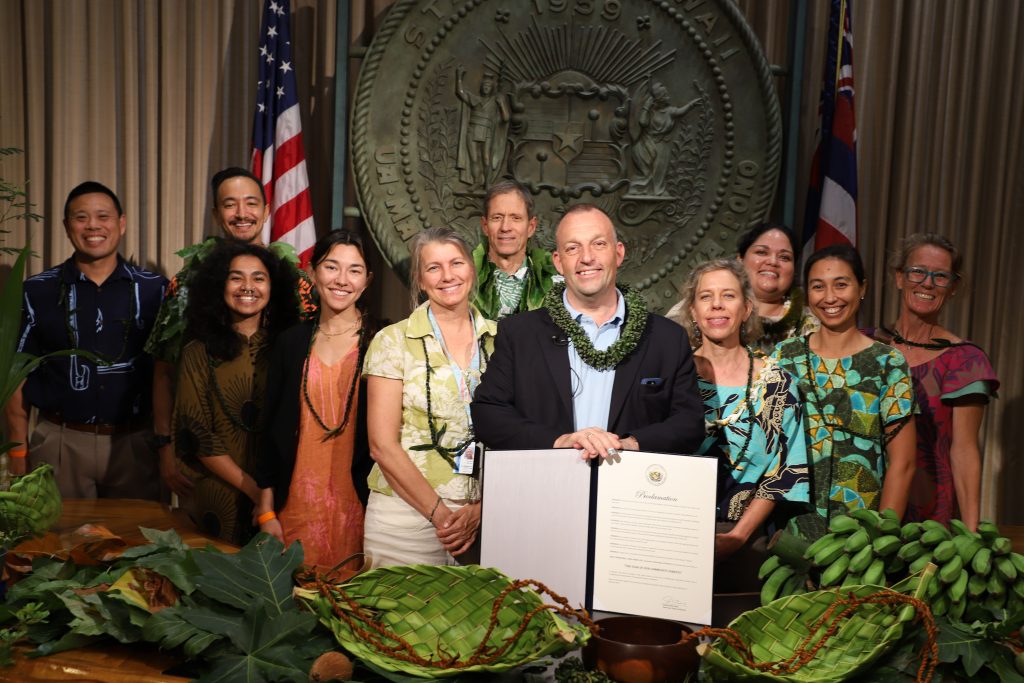
DLNR First Deputy Ryan Kanaka‘ole, whose family roots are in Wai‘ōhinu, joined Gov. Josh Green to announce that 2025 is
The Year of Our Community Forests. Photo from Gov. Green

2025 IS THE YEAR OF OUR COMMUNITY FORESTS, according to a proclamation signed this month by Gov. Josh Green. The idea was developed by the state Department of Land & Natural Resources' Division of Forestry & Wildlife, and its Kaulunani Urban & Community Forest Program, along with a multitude of partners. The designation recognizes trees and forests in the wao kanaka: where humans live, learn, and play. The year-long campaign has the goals of increasing awareness of community forests and strengthening connections between people and these forests.
     “Community forests are the trees in our neighborhoods, yards, parks, schools, and along our streets,” said Green. “These forests can include native species, but also non-invasive beneficial trees like ‘ulu, niu, mango, and others.
    Also speaking at the proclamation signing was DLNR First Deputy Ryan Kanaka‘ole, who comes from Wai‘ōhinu in the District of Kaʻū with the state's largest native forests and historic villages with many mature trees. He said, “We all live in a community forest, they’re not just mauka, but all around us. Our trees are what makes Hawai‘i home. They’re not only ornamental landscaping, but also provide food, shade, oxygen, habitat, and many other benefits. Trees are also great for hanging ornaments and holiday lights.”
    DOFAW has established a website where people can learn about all the benefits of community forests, about volunteer opportunities associated with the Year of Our Community Forests, and statistics and data on how forests help grow communities.
Gov. Josh Green after signing the proclamation declaring
2025 The Year of Our Community Forests.  Photo from Green

   “We tend to view forests for the conservation values associated with them,” said DOFAW Administrator David Smith. “They also have great economic value, with urban forestry having a $64 billion footprint nationwide in 2017. The same report indicated urban forests support more than a half million jobs. Another study found employees are more productive and less stressed when trees are nearby and they also increase property values.”
    “Most importantly,” the Governor added, “is what trees provide for our environment. They make water cleaner by filtering pollutants and holding onto soil to reduce runoff into the ocean. Trees clean the air by filtering pollutants, and they capture carbon dioxide (CO2) which helps to mitigate climate change.”
   Hawai‘i municipal trees store more than 25,000 tons of CO2, remove a net 3,340 tons of CO2 each year, and manage 35 million gallons of stormwater runoff each year.
    Learn more and see community opportunities at www.dlnr.hawaii.gov/trees.

To read comments, add your own, and like this story, see facebook.com/kaucalendar. See upcoming events, print edition and archive at kaunews.com.


DEADLINE FOR SUBMISSION TO VOLCANO AWARENESS MONTH ART & POETRY CONTEST is Monday, Jan. 20. The contest celebrates recognizing the dynamic volcanic landscapes of Hawaiʻi nei.
    "We welcome submissions from Kamaʻaina, visitors, anyone with an interest in Hawai'i’s volcanoes," says the statement from the organizers at USGS Hawaiian Volcano Observatory. See more information at https://d9-wret.s3.us-west-2.amazonaws.com/assets/palladium/production/s3fs-public/media/files/2025_VAM_art_poetry_contest_final.pdf


5,000 delivered in the mail, 2,500 on the streets.
 

Friday, January 17, 2025

Kaʻū News Briefs Jan. 17, 2025

Color photograph of eruption
High Lava Fountains, Some Unhealthy Air
View from the southwest rim of Kaluapele, the summit caldera of Kīlauea, where the temporary S2 webcam is located. This view looks down on the active north and south vents on the morning of January 17 as lava fountains reached 100-115 ft (30-35 m) high and fed lava flows in the western part of Halemaʻumaʻu. The volcanic plume was going almost straight up from the lack of wind. USGS photo by D. Downs

UNHEALTHY AIR GREETED Pāhala Friday morning with haze hanging in the village and blanketing the mountains and coast. At 8 a.m., the air quality was rated Unhealthy, with the red symbol on the state Department of Health's air quality map. Nāʻālehu's air was rated Moderate. By noon, the intermittent breeze had blown much of the vog away and air quality became Moderate, then Good. For Pāhala and Nāʻālehu, air quality returned to Moderate in the evening.

To read comments, add your own, and like this story, see facebook.com/kaucalendar. See upcoming events, print edition and archive at kaunews.com.

A TRAGIC 2024 TRAFFIC FATALITY & DUI REPORT FROM HAWAI'I POLICE DEPARTMENT has been released. 
    In 2024 there were 26 fatal crashes on Hawai'i Island, resulting in 29 fatalities, compared with 14 fatal crashes resulting in 15 fatalities in 2023. This represents an increase of 85.7 percent for fatal crashes and 93.3 percent for fatalities.
    For the year 2024, there were 964 Driving Under the Influence of an intoxicant arrests compared with 955 in 2023, an increase of 0.94 percent.

    Impaired drivers involved in traffic collisions and impaired drivers under the age of 21 both saw increases in 2024 compared to the preceding year. There were 277 drivers arrested for driving under the influence of an intoxicant who were involved in traffic collisions in 2024, compared with 254 in 2023, an increase of 9.1 percent. Meanwhile, 71 drivers arrested for driving under the influence of an intoxicant who were under the age of 21 in 2024, compared with 65 in 2023, an increase of 9.2 percent. Major traffic collisions increased in 2024, with 987 major collisions compared to 843 in 2023, an increase of 17.1 percent.
    HPD promises that DUI roadblocks and patrols will continue island wide.

To read comments, add your own, and like this story, see facebook.com/kaucalendar. See upcoming events, print edition and archive at kaunews.com.

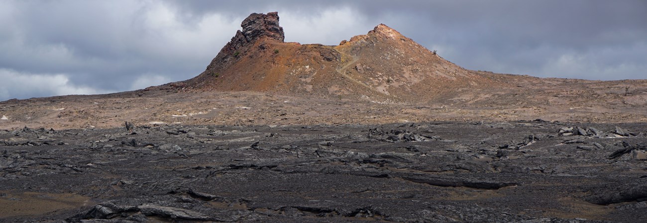
A sunlit cinder cone in a gray volcanic landscape
A cone along the Maunaiki Trail. A hike begins at 10 a.m. Saturday at Kaʻū Desert Trailhead on Highway 11
in Hawaiʻi Volcanoes National Park, one of the many Volcano Awareness Month events. NPS Photo by A. LaValle

HIKE THE KAʻŪ DESERT TRAIL ON SATURDAY MORNING at 10 a.m. as Volcano Awareness Month continues. Traverse Mauna Loa’s Keamoku ʻaʻā lava flow and find the footprints in Kīlauea’s 1790 
explosive ash deposit during this guided hike to the Footprints shelter in Hawai‘i Volcanoes National
Park.
    University of Hawaiʻi at Hilo Geology Department faculty and geologist Cheryl Gansecki will talk about the geologic features along the trail in this unique region where Mauna Loa, Earth’s largest active volcano, and Kīlauea, one of Earth’s most active volcanoes, meet. Gansecki will tell the story of the fatal explosive eruption of Kīlauea in 1790, which deposited ash that preserves footprints of that time period.        Adventurous hikers can continue on to Maunaiki to explore vents and lava flows of the 1919–1920 eruption (adds an additional moderate hike of +2 miles roundtrip). Meet at 10 a.m. at the Kaʻū Desert 
Trailhead on Highway 11 in Hawaiʻi Volcanoes National Park.
    To read more about the trail and history Footprints area, see: https://www.nps.gov/havo/planyourvisit/footprints.htm

To read comments, add your own, and like this story, see facebook.com/kaucalendar. See upcoming events, print edition and archive at kaunews.com.


5,000 delivered in the mail, 2,500 on the streets.


Thursday, January 16, 2025

Kaʻū News Briefs Jan. 16, 2025

Color photograph of erupting lava fountains
On Thursday, Jan. 16, the south fountain (left) during the ongoing Kīlauea eruption's fourth eruptive episode, had an average height of about 40 meters (131 feet). The north fountain (right) ranged in height between 50–60 meters (164–197 feet). Fountain heights slightly decreased from Wednesday's maximum measured fountain heights of 90–100 meters (295–328 feet).
USGS photo by H. Winslow
TINY CRYSTALS & THEIR TRIP THROUGH MAGMA CHAMBER is the focus of this week's Volcano Watch, the weekly column by USGS Hawaiian Volcano Observatory scientists and affiliates. This week's article is by HVO post-doctoral researcher Heather Winslow:
    Like fortune tellers who peer into a crystal ball for insight, volcanologists at the USGS Hawaiian Volcano Observatory (HVO) peer into the tiny crystals contained in lava flows to learn about the magma's journey before it was erupted onto the surface.
    When magma cools prior to eruption, crystals grow and develop chemical zones that record changes in the environment around them. Scientists study chemical differences in these zones, which can provide information on how hot the magma was (thermometry), how deep it was stored (barometry), what the compositional makeup of the magma was (geochemistry), and how long the magma was stored prior to an eruption (diffusion chronometry).
 
(A) Spatter cone samples from the Kīlauea middle East Rift Zone eruption in and near Nāpau Crater from September 15–20, 2024. Crystals were collected from samples like this. (B) Back-scattered electron image of a plagioclase crystal from the September 2024 Kīlauea middle East Rift Zone eruption. This crystal shows two distinct chemical zones from its core to rim. The core has a different composition from the rim of the crystal, representing a change in magmatic environment likely from the intrusion that triggered the eruption. (C) Back-scattered electron image of an olivine crystal from the Kīlauea Halema'uma'u Dec. 2024–Jan. 2025 eruption. This is an olivine grain that has typical Kīlauea summit eruption compositions. USGS images
    
    What is fascinating is that these micron-scale (0.00004 inches) changes in individual crystals can be used to derive understanding about volcanic systems as a whole. To give some context, a human hair is about 100 microns (0.004 inches) thick. We are looking at chemical changes in crystals on the scale of 1-5 microns (0.00004–0.0002 inches), and those very small changes tell us what was happening to the magma prior to it erupting at the surface.
    In Hawai'i, the most common mineral we study is the green-colored olivine. We can use olivine as a "crystal clock" to determine the timing of magmatic events leading up to eruption which was discussed in detail in a previous Volcano Watch here.
 
Heather B. Winslow, PhD | U.S. Geological Survey
Heather Winslow of USGS Hawaiian
Volcano Observatory.
   Two other minerals that we observe in Hawaiian eruptions are pyroxene and plagioclase. While olivine is typically the first mineral to crystallize, pyroxene and plagioclase crystallize later and thrive in different magmatic environments at different temperatures and pressures.
    An easy way to think about these crystals and how they record magmatic events is to envision yourself as a journalist outside of a sporting event, and you need to know what happened at the game by interviewing different spectators (crystals). Some spectators show up early and witness the entire event, some arrive late, some are seated close to the action, and some roamed the stadium and forgot certain events even happened. Different crystals are the different fans that are all observing the game (or magmatic event) with a different perspective.
    This analogy originated out of observing the complexities and nuances in olivine alone, but it can be extended to apply to the variety of crystals in magmatic system as well. Thus, by studying the range of crystals, we get to learn about the magmatic system from a multitude of perspectives.
    This method was applied to study the two most recent eruptions of Kīlauea, in collaboration with the University of Hawaiʻi at Hilo Geology Department. From Sept. 15-20, Kīlauea erupted in and near Nāpau Crater on the middle East Rift Zone. During the opening phase of this eruption, we collected molten and spatter samples that were rapidly cooled by submerging the samples in water or quenched in the air. This preserves the pre-eruptive chemistry.
    From those samples, we analyzed bulk chemistry, which showed compositional differences compared to typical lavas erupted at Kīlauea summit. While there was evidence for new magma intrusion into Nāpau Crater area through seismic and deformation data, the chemistry indicated that previously stored magma had been erupted from the rift zone. Plagioclase crystals from the opening phases of the eruption had unique chemical zoning; the interior reflects growth in magma that was likely previously stored, while the outer zone has a different chemistry that was influenced by the new magma that intruded from the summit.
    Kīlauea summit erupted at Halemaʻumaʻu from Dec. 23 to Jan. 3, in three distinct episodes. HVO staff collected molten samples of lava from the caldera floor and airfall samples from the lava fountain that fell on the crater rim. Olivine crystals analyzed from the first episode of the eruption mostly show typical Kīlauea summit compositions; however, some minerals show differences between their cores and rims that could suggest magmatic transfer from multiple magma storage regions beneath the summit of Kīlauea.
    These differences in crystal compositions helps us understand what happened to the magmas beneath the surface. If you're interested in learning more about Hawai'i's active volcanoes, see the Volcano Awareness Month schedule of events here!
Color photograph of erupting vents and small lava flows
View of the Kīlauea summit eruption in Hawaiʻi Volcanoes National Park, from the south rim of the caldera. The caldera wall behind the erupting vents is approximately 210 meters (690 feet) tall.  Thursday morning, USGS Hawaiian Volcano Observatory field crews reported lava fountain heights of 50 meters (160 feet) and 40 m (140 feet) from north and south vents, respectively. At about 8:25 a.m. field crews reported that parts of the south vent collapsed, with an associated reduction of about half in south vent lava fountain height. Lava flow activity has remained confined to the southwest crater floor area near the active vents. USGS photo by K. Lynn.
VOLCANO ACTIVITY UPDATES:
    Kīlauea is erupting. Its USGS Volcano Alert level is WATCH. The eruption within Halemaʻumaʻu at the summit of Kīlauea resumed just after 9:00 a.m. on Wednesday, January 15, after being paused for nearly 12 days. Small fountains began at about 5:40 a.m. followed by lava flows just after 9:00 a.m. and the resumption of fountaining from the northern vent by 10:00 a.m. The onset of episode 4 began toward the end of the time window (January 9-15) that HVO had identified where an eruption restart was most likely. Kīlauea summit has been steadily deflating as episode 4 of the eruption continues. No unusual activity has been noted along Kīlauea's East Rift Zone or Southwest Rift Zone. Sulfur dioxide emission rates are elevated in the summit region. Earthquake rates in the Southwest Rift Zone and upper to middle East Rift Zone remained comparable to the previous week. Ground deformation rates outside of the summit region remained steady.
    Mauna Loa is not erupting. Its USGS Volcano Alert Level is at NORMAL.
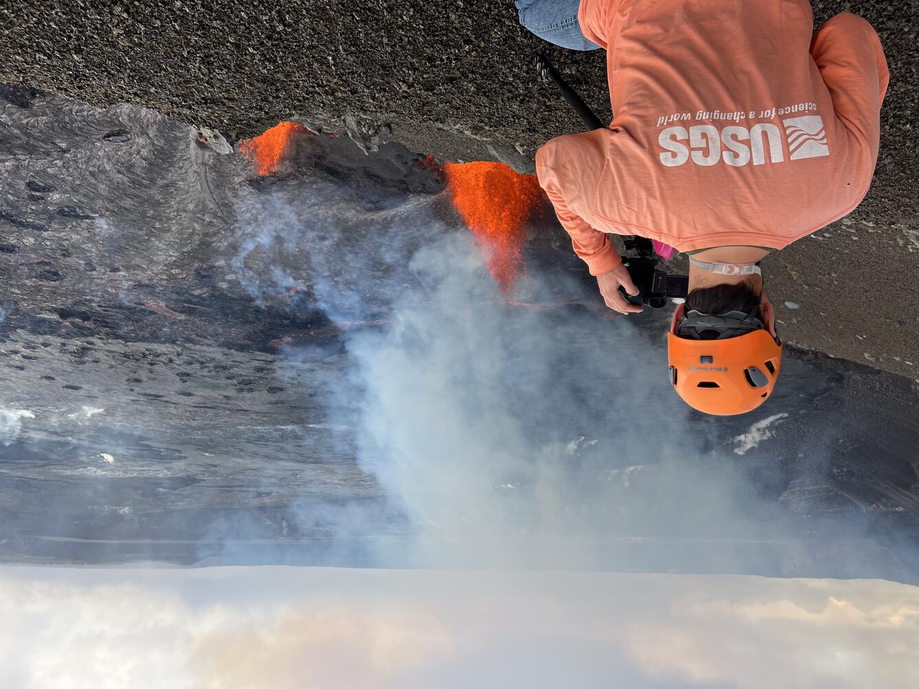
Color photograph of scientist monitoring eruption
During the reactivation of the Kīlauea summit eruption, USGS Hawaiian Volcano
 Observatoryscientists set up high resolution cameras to record eruption dynamics.
 While on field shifts, scientists measure fountain and cone heights, take thermal and
 observational images, and collect samples for monitoring purposes. During the field
 shift on Thursday, Jan. 16, staff were able to collect time-stamped airfall samples
 falling out of the plume. This photo is looking NE toward Volcano House from
 the west caldera rim. USGS photo by H. Winslow

    Five earthquakes were reported felt in the Hawaiian Islands during the past week: a M2.9 earthquake 12 km (7 mi) SSE of Fern Forest at 7 km (4 mi) depth on January 13 at 10:44 a.m. HST, a M3.1 earthquake 10 km (6 mi) NE of Pāhala at 33 km (20 mi) depth on January 12 at 11:27 a.m. HST, a M3.2 earthquake 19 km (11 mi) NNE of Honoka'a at 11 km (7 mi) depth on January 10 at 10:34 a.m. HST, a M3.1 earthquake 19 km (11 mi) NE of Kukuihaele at 5 km (3 mi) depth on January 10 at 9:31 a.m. HST, and a M3.1 earthquake 14 km (8 mi) S of Fern Forest at 7 km (4 mi) depth on January 9 at 8:30 a.m. HST.
    HVO continues to closely monitor Kīlauea and Mauna Loa.
    Visit HVO's website for past Volcano Watch articles, Kīlauea and Mauna Loa updates, volcano photos, maps, recent earthquake information, and more. Email questions to askHVO@usgs.gov.

Farmer Veteran Fellowship Fund
To read comments, add your own, and like this story, see facebook.com/kaucalendar. See upcoming events, print edition and archive at kaunews.com.


A FARMER VETERAN FELLOWSHIP FUND  application is open
This is a small grant program that provides direct assistance to Veterans who are in their beginning years of farming or ranching.            
    Awards range from $1,000 to $5,000. The application will close on Feb. 14 at 7 p.m. with awards set to be announced in May. 
    To apply, visit the FVC website. Email fellowship@farmvetco.org with any questions.

NATURAL RESOURCE CONSERVATION NCRS ASSISTANCE PROGRAMS for 2025 are open for applications.
USDA Natural Resources Conservation Service

    USDA NRCS in the Pacific Islands area is now considering proposals from farmers, ranchers, and foresters in the Pacific Islands area through Jan. 31 for technical and financial assistance through the NRCS Agricultural Conservation Easement Program, Agricultural Management Assistance program, Conservation Stewardship Program, Environmental Quality Incentives Program, and Regional Conservation Partnership Program. Applications and more information are available at local USDA Service Centers and online.

To read comments, add your own, and like this story, see facebook.com/kaucalendar. See upcoming events, print edition and archive at kaunews.com.


5,000 delivered in the mail, 2,500 on the streets.