About The Kaʻū Calendar

Tuesday, November 15, 2022

Kaʻū News Briefs, Tuesday, Nov. 15, 2022

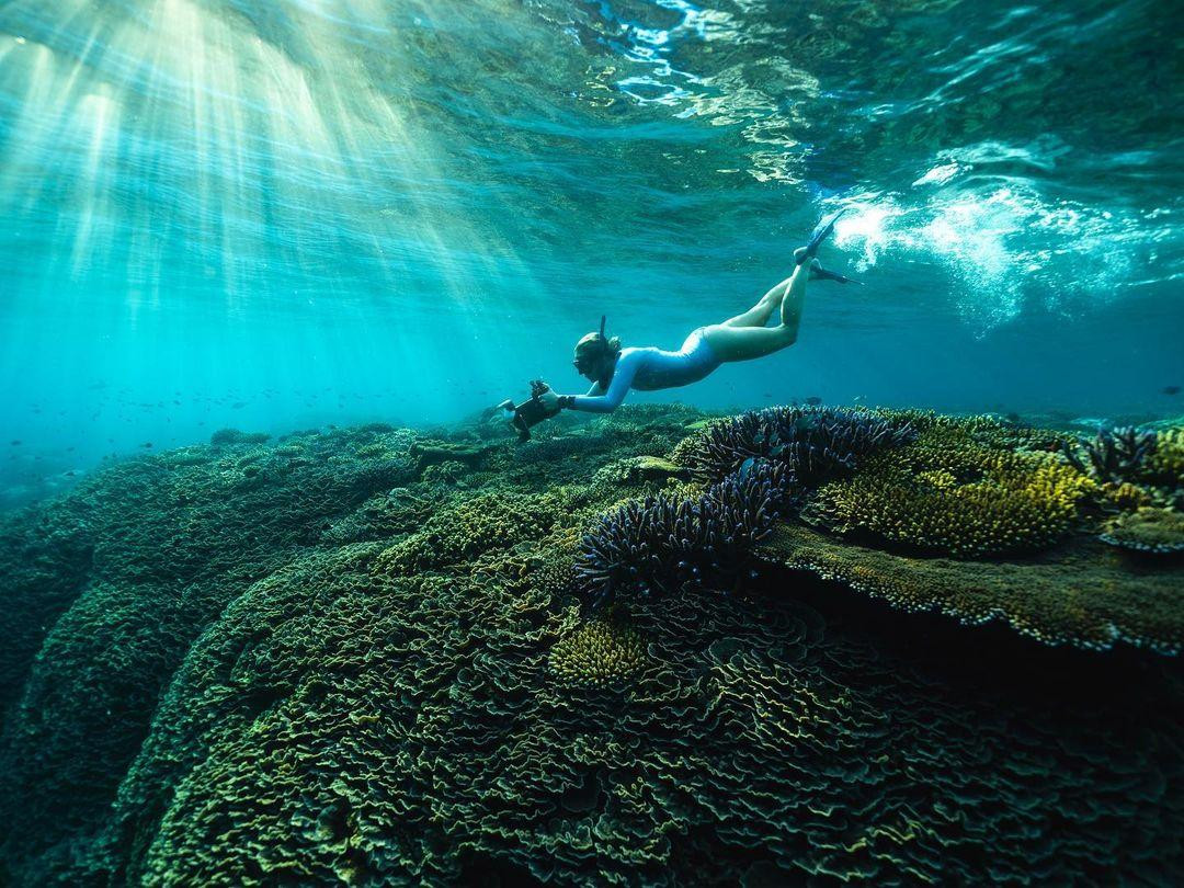
Surfer and scientist Dr. Cliff Kapono, whose father lives in Waiohinu, is on the MEGA Lab team in Hilo, mapping surf spots
internationally to protect them. He is also an ambassador for surf apparel brand REEF, which helps fund the program.
Photo from REEF

THE MEGA LAB IN HILO IS MAPPING TOP SURF SPOTS IN THE WORLD to help protect them. MEGA stands for Multiscale Environmental Graphical Analysis. A statement from its operatives and University of Hawai'i enlightens: "With more than 80 percent of the world’s oceans left unexplored, untouched and unseen by humans, researchers know more about the surface of Mars than the ocean."
Dr. John H.R. Burns
Image from MEGA Lab
     University of Hawaiʻi at Hilo professor, Dr. John H.R. Burns, leads the team of scientists to 3D map the planet’s premier surf breaks to help better protect reefs around the world. Burns, along with Dr. Haunani Kane and Dr. Cliff Kapono, both of Arizona State University, recently mapped the reef at Kurukuru Mailani in Fiji, also known as Cloudbreak, which is home to some of the biggest and best waves in the world. The team takes high resolution images of the reef and uses a technique called photogrammetry to create 3D reconstructions that can be studied to help provide a better understanding of reef systems.
    “These models will help us to understand the composition, characteristics and ecology of the reef and these waves that will help us to protect them in the face of disturbances such as sea level rise,” said Burns, an associate professor of marine science at UH Hilo.
Dr. Cliff Cliff Kapono
Image from MEGA Lab
   According to the UH statement, the researchers are skilled surfers and base their work out of the MEGA lab in Hilo. The MEGA Lab specializes in inventing new methods to study coral health and reef formation that influences the shape and speed of waves across the globe. The non-profit is a global consortium of scientists, athletes and artists working together to create innovative solutions to protect the ocean.
    UH students and alumni Kailey Pascoe (MS, UH Hilo, PhD ASU), Crispin Nakoa (MS, UH Hilo, PhD ASU), Atsuko Fukunaga (MS, UH Mānoa) are analyzing data collected in Fiji and constructing high definition 3D reconstructions in the MEGA Lab.
    “The 3D maps give us this framework, essentially a basis of the whole system and its structure and then we figure out which specific corals are supporting various types of fish and ultimately we can dissect what elements of the reef give us the food and the resources that we as humans depend on,” said Burns.
Dr. Haunani Kane
Image from MEGA Lab
    The 3D reef mapping project born out of the MEGA Lab is a collaboration between the Hawaiʻi Island-based lab, surf apparel brand REEF and Surfline, a surf forecast and news website. The project first launched in 2021 at the legendary surf break Banzai Pipeline on Oʻahu’s North Shore. The surfing scientists conducted multiple trips to the North Shore to image the famous surfing spot known for its jagged, sharp reef.
    “Many funding agencies may see this type of trip as strictly play, but we are doing real science down here,” said Kapono, who is the son of the Cliff Kapono who lives in Waiohinu.
   The team has not disclosed where their next reef research will take place however they do mention looking for possible spots in the South Pacific and aim to include local communities into the research.
   “It’s important to remember that we are visitors in these places and learn from the Indigenous peoples before we impose our tools on the community,” said Kane.
    More on the MEGA Lab: This fall, MEGA Lab celebrated the grand opening of its new outreach location at Mokupāpapa Discovery Center in Hilo. The lab is open to the public and provides a space for visitors of all ages to learn and participate in branches of research connected to marine science.
  Research technician Kailey Pascoe mapping Cloudbreak reef in Fiji, one of the best surfing spots on the planet.  
Photo by Todd Glaser

    “We really want to create an engaging place for people to feel like they can be a part of science. For a while, science hasn’t been the most welcoming environment. It can be somewhat rigid and sterile. We just wanted to flip that script and show students that you can have fun. You can chase your passions. You can be yourself,” said Burns.

To read comments, add your own, and like this story, see www.facebook.com/kaucalendar. See latest print edition at wwwkaucalendar.com. See upcoming events at https://kaunewsbriefs.blogspot.com/2022/04/upcoming-events-for-kau-and-volcano.html.

Children with disabilities are invited to Surfers Healing Camp on Saturday, Dec. 3.
Photo from Surfers Healing

A SURFERS HEALING CAMP IS OPEN TO CHILDREN WITH DISABILITIES islandwide. Hawai'i County Department of Parks & Recreation made the announcement Tuesday that the Surfers Healing Camp will be held on Saturday, Dec. 3 from 9 a.m. to noon at Richardson Ocean Park in Hilo. Experienced surfing instructors, surfboards, and life vests will be provided. This event is free for all participants.
    Surfers Healing is a national organization whose goal is to share the joy of surfing with those who otherwise would not have the opportunity to surf. Surfers Healing Camps are held worldwide, providing more than 6,000 children the opportunity to experience surfing annually. For the past 13 years, Surfers Healing Hawai'i Chapter has offered children with disabilities and their families the unique experience of surfing with professionals under supervised conditions. This free event is offered through a partnership between the county, Surfers Healing Hawai'i Chapter, the Eddie Aikau Foundation, Vans International, and Double Good.
    To register a child and learn more about the camp, visit www.surfershealing.org. Space is limited. For additional information, call the Recreation Division office at 808-961-8740.

To read comments, add your own, and like this story, see www.facebook.com/kaucalendar. See latest print edition at wwwkaucalendar.com. See upcoming events at https://kaunewsbriefs.blogspot.com/2022/04/upcoming-events-for-kau-and-volcano.html.   
FARMERS AND RANCHERS ARE ALERTED THAT CROP INSURANCE deadlines are looming. The application period closes Dec. 31 for coffee trees, coffee fruit, banana trees, macadamia nut trees, macadamia nuts, and papaya trees. 
     Crop insurance agent Bonnie Lind is on island to meet farmers and ranchers in-person to teach them about coffee crop insurance and the federal Whole Farm Revenue Protection Program. She met with Ka'u Coffee farmers on Monday and is available again on Thursday at the CTAHR Kona Extension Service Conference Rom at 79-7381 Mamalahoa Hwy in Kealakekua from 2 p.m. to 6 p.m. Phone 888-276-7728 or email agsecure@sbcglobal.net.
    University of Hawai'i staff will host a live Q&A panel discussion on ag insurance this Thursday, Nov. 17 and again Thursday, Dec. 1, both at 9:30 a.m. Register at www.HawaiiCoffeeEd.com/coffeeinsur or call 808-3220164.
    USDA Risk Management Agency is hosting a roadshow event on the Whole Farm Revenue Protection Program and Micro Farm insurance programs for specialty crop and organic producers. Its next webinar is on Tues., Dec. 13 at 6 a.m. HST.

Monday, November 14, 2022

Kaʻū News Briefs, Monday, Nov. 14, 2022

Kaʻū Coffee farmer Berta Miranda shares the story of building her family business as Taiwan
buyers listen during a trade mission to Kaʻū and other coffee growing regions. Photo by Julia Neal

A TRADE MISSION FROM TAIWAN recently visited Kaʻū. Hawai'i Coffee Association reported on Monday that Synergistic Hawai'i Agriculture Council representatives hosted a group of coffee buyers, roasters, and company executives from Taiwan who visited coffee farms and venues in Ka'u, Kona and Hilo, as well as Honolulu.
    Among those who met with Kaʻū Coffee Farmers at Pahala Plantation House and visited Kaʻū Coffee Mill and area farms was Alex C. Lei, Executive Director for the State of Hawai'i Office in the Taipei World Trade Center. Lei has worked in Taiwan on behalf of this state for more than two decades, helping to foster trade.
Alex Lei led a mission to Kaʻū
to promote the buying of local
coffee. Photo by Julia Neal
    Also from Taiwan were representatives of some of the country's, largest coffee buyers, roasters, wholesalers, retailers and owners of chains of coffee shops. Among the manufacturers is the Mr. Brown brand, which is sold in cans and found in stores in Kaʻū. Also represented were high-end coffee sellers who said the Taiwan market has matured for expensive coffees like those produced in Kaʻū.
     During the trade mission event, which was partially funded by the federal government, Kaʻū Coffee farmers told the stories of building their industry. Representatives from Taiwan told the stories of building their coffee businesses. They all met at Pahala Plantation House after the presentations to talk about building trade between them.
    According to the Hawai'i Coffee Association statement, SHAC Board reps Ralph Gaston and Madeleine Longoria Garcia coordinated the trip in partnership with the State of Hawaii's Department of Business, Economic Development & Tourism offices in Honolulu and Taipei. 
    In addition to the trade meeting at Pahala Plantation House, there were several opportunities for growers to connect to forge business relationships and increase Hawai'i coffee knowledge and exports to Taiwan. "We look forward to the benefits of this trip in the coming years," said the Hawai'i Coffee Association statement.

Buyers from Taiwan recently visited Kaʻū and other coffee regions in a trade mission sponsored
by state and federal agencies. Photo from Hawai'i Coffee Association

To read comments, add your own, and like this story, see www.facebook.com/kaucalendar. See latest print edition at wwwkaucalendar.com. See upcoming events at https://kaunewsbriefs.blogspot.com/2022/04/upcoming-events-for-kau-and-volcano.html.

A FOOD PROCESSING GRANT has been issued to Hawai'i Island non-profit Olohana Foundation, which recently purchased aseptic legacy juice processing equipment to make food puree products. The $101,491 grant for its project, Hawaiʻi Tropical Fruits: Adding Value for Shared Abundance, is for a year-long prototype program for processing puree products from locally grown, soft-skin fruit that might
otherwise go to waste in the absence of a market for them. The puree's will go to the public initially through The Food Basket's Da Box and Hawai'i Farm to Car.
    Project co-directors Carly Wyman and Keahi Tajon in partnership with Arizona State University examined strategies for re-establishing the juice processing equipment on this island. Olohana announced Monday that it invites local partners and investors to submit proposals to expand and strengthen the project and increase impact. “This is an opportunity to leverage our investments,” said Sarah Purgus, Executive Director of the Olohana Foundation. “It’s an economic opportunity that bodes well for all involved.”  
    Sen. Mazie Hirono issued a statement this week, announcing funding of $101,491. The US Dept. of Agriculture's Local Foods Production Program oversees the money and issued a statement:
    "The Hawaiian islands lack adequate food processing infrastructure for increased food self-sufficiency and food security for residents and visitors alike. Meanwhile, Hawai'i’s small farmers (66% of farms are under 9 acres in size) struggle to make a profit, facing the highest production costs in the US.    
Soft skinned fruits will be made into
a puree to sell, in order to reduce
food waste and help small farmers.
Photo from Olohana Foundation
    "The purpose of this project is to address these twin challenges of lack of food processing capacity for local crops, and increasing profits for small farmers through adding value to local crops.               "The Olohana Foundation recently acquired legacy industrial juicing equipment which we wish to put into operation once again, providing a valuable option to local farmers for adding value to their tropical fruit crops and reducing on-farm food waste. In collaboration with local fruit producers, this project will pilot the production of two new local value-added fruit products utilizing food processing equipment.        "These final food products will be routed directly into the local food system via the Food Basket: Hawai’i Island’s food bank, and Hawai’i Farm to Car farmers market. By developing these two new fruit products, this project will be directly growing the mid-tier value chain infrastructure for Hawaiʻi Island and beyond, increasing local capacity for aggregation, processing and distribution. An estimated 33 local fruit producers will benefit from this new market for their crops, including B grade crops, which will help to reduce on-farm food waste. Additionally, this project will reach an estimated 452 local consumers, providing an affordable, local and healthy food option." 
   Olohana is based in Pauilo. Parties, islandwide, may submit collaboration proposals to info@olohana.org.
 To read comments, add your own, and like this story, see www.facebook.com/kaucalendar. See latest print edition at wwwkaucalendar.com. See upcoming events at https://kaunewsbriefs.blogspot.com/2022/04/upcoming-events-for-kau-and-volcano.html.

FRIENDS OF HAWAI'I VOLCANOES NATIONAL PARK celebrates its 25th anniversary of supporting the park by hosting a December events at Kahuku unit on the Kona side of Kaʻū.
    Holidays at Kahuku will be Saturday, Dec. 3 from 10 a.m. to 3 p. Local craft booths for holiday gifts, hula, music, food booths, and free shave ice and face painting will be offered.
    A Coffee Talk presentation about hāhā, a critically endangered endemic Hawaiian plant, will be held Dec. 17 at 9:30 a.m. at the Visitor Contact Station. Learn about the plant and what the Park is doing to save it from extinction.
    December is the last month of the Kūkini Challenge. Hikers and walkers can turn in miles, recording them at the Visitor Contact Station for a chance to win a silver water flask and accolades for the fourth quarter of 2022.
    Kahuku will be closed on Christmas and New Yearʻs days. "We wish you all the happiest of holidays and a Hauʻoli Makahiki Hou!" said ranger Wendy Scott-Vance.
   
To read comments, add your own, and like this story, see www.facebook.com/kaucalendar. See latest print edition at wwwkaucalendar.com. See upcoming events at https://kaunewsbriefs.blogspot.com/2022/04/upcoming-events-for-kau-and-volcano.html.


Sunday, November 13, 2022

Kaʻū News Briefs, Sunday, Nov. 13, 2022

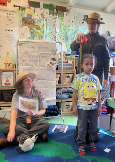
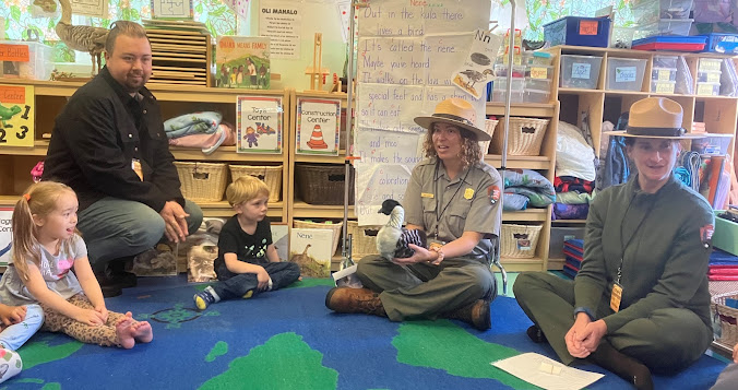
Students learn the difference between the extinct giant Hawaiian goose and nēnē. Photo from Volcano School of Arts & Sciences

Rangers teach Volcano School 
keiki about nēnē. Photo from VSAS
PRE-K STUDENTS AT VOLCANO SCHOOL OF ARTS & SCIENCES recently received rangers from Hawai'i Volcanoes National Park, along with some nene friends. The rangers taught students about the differences between the extinct giant Hawaiian goose and nēnē, the Hawai'i state bird.  Students enjoyed comparing their sizes to the height of the giant Hawaiian goose and learned about the nēnē habitat and keeping the nēnē safe.  Students performed their Nēnē Mele, took turns petting the nēnē, and observed `ohelo berries, the bird's favorite food.  A statement from the school said, "PreK students would like to say mahalo to the rangers for helping them learn about the nēnē and celebrate the letter 'n.'"

To read comments, add your own, and like this story, see www.facebook.com/kaucalendar. See latest print edition at wwwkaucalendar.com. See upcoming events at https://kaunewsbriefs.blogspot.com/2022/04/upcoming-events-for-kau-and-volcano.html.


COFFEE TALK: BIRDS NOT MOSQUITOES! is the session next Saturday, Nov. 19 from 9:30 a.m. to 11 a.m. at Kahuku Visitor Contact Station on the west end of Hawai'i Volcanoes National Park.
A juvenile 'i'iwi, one of the endemic Hawaiian
 honeycreepers impacted by avian malaria.
NPS Photo by Janice Wei
    A message from the Park says that "Avian diseases transmitted by non-native mosquitoes have severely depleted native Hawaiian forest bird populations. There is hope and an opportunity to use a common bacteria to reduce mosquito populations, break the disease cycle and allow the forest birds to thrive. Birds, Not Mosquitoes is a collaboration of state, federal and nonprofit organizations working together to implement this tool." Join Chris Farmer of the American Bird Conservancy and Evelyn Wight of The Nature Conservancy to learn about this promising initiative. The event is one of Hawaiʻi Volcanoes’ ongoing Kahuku Coffee Talk series.

To read comments, add your own, and like this story, see www.facebook.com/kaucalendar. See latest print edition at wwwkaucalendar.com. See upcoming events at https://kaunewsbriefs.blogspot.com/2022/04/upcoming-events-for-kau-and-volcano.html.

A RESEARCH GEOLOGIST NAMED DREW DOWNS writes about American Samoa volcano activity in Volcano Watch, the  weekly article and activity update by U.S. Geological Survey Hawaiian Volcano Observatory scientists and affiliates. He focuses on Ta‘ū volcano's unrest in the form of an earthquake swarm that was felt throughout the Manuʻa Islands (Ofu-Olosega and Ta‘ū Islands) from late July through early September 2022. He writes:
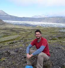
Drew Downs studies volcanoes internationally,
including Iceland above and American Samoa,
which is his subject in this Volcano Watch.
USGS photo
    At its peak, as many as 30–40 earthquakes were detected per hour. Most earthquakes were too small to be felt, but some days dozens were noted by residents of the Manuʻa Islands, likely magnitude 2–4.
In response, the U.S. Geological Survey’s Hawaiian Volcano Observatory (HVO) rapidly deployed monitoring equipment and staff, who met with federal and local partners to assess the situation, and help respond to any future hazards (https://www.usgs.gov/volcanoes/ta-u-island/news/volcano-watch-hvo-responds-american-samoa-earthquake-reports).
     American Samoa comprises the easternmost islands of the Samoan archipelago in the south Pacific. These include the islands of Tutuila (the population center) and the Manuʻa Islands about 60 miles (100 km) to the east. These islands are the tops of shield volcanoes, which are mostly submerged to 15,000 ft (4,500 m) beneath the ocean surface. Other volcanoes created by the Samoan hotspot are still completely below the ocean, such as the Vailuluʻu seamount located about 25 miles (40 km) east of Ta‘ū.
    Despite being near the Pacific’s famed ‘Ring of Fire,’ the volcanoes of the Samoan Islands were created by a hotspot in much the same way as the Hawaiian Islands. This type of volcanism tends to produce shield volcanoes known for their distinctive broad shape. The volcanoes in nearby Tonga are of a different type related to subduction at the Tonga Trench, and consequently, an eruption like the one that occurred at Hunga.
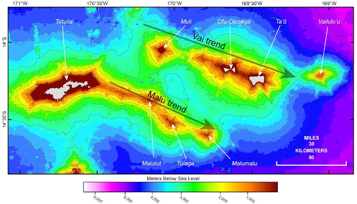
Bathymetric data from the National Oceanic and Atmospheric Administrationcollected around American Samoa. Light gray areas are the islands of Tutuila,Ofu-Olosega, and Taʻū. Black lines are 1,640 ft (500 m) contour intervals below sea level. The Samoan hotspot has created volcanoes along two tracks, the Vai (to the north) and Malu (to the south) trends, but with most of the volcanoes remaining below sea level as seamounts. The Samoan hotspot is thought to be near the easternmost seamount of Vailuluʻu.

    Vailuluʻu is the most recently active volcano, within American Samoa, with three eruptions since the 1970s. These eruptions occurred nearly 2,000 ft (600 m) below the ocean surface and produced lava flows. It is difficult to confirm Vailuluʻu eruptions without ship-based ocean floor mapping. Occasional sea-floor mapping, from time-to-time, looks for changes in topography of the volcano.
    Most eruptions in American Samoa produce relatively slow moving lava flows that are similar to eruptions in Hawaiʻi. Rarer are small explosions where magma and water interact. There is evidence, in the past, of small explosive eruptions that threw out bombs of molten rock and colder, dense rock a few hundred yards (few hundred meters) away from their volcanic vents. These bombs can reach over a yard (meter) in size and are usually in tuff cones that are mostly made of volcanic glass shards with a texture similar to sand and flour. These types of eruptions occur when magma comes into contact with shallow groundwater or near the coast in the shallow marine environment.
    Such an eruption happened about two miles (3 km) offshore to the east of Ofu-Olosega in 1866. On September 7, 1866, residents of the Manuʻa Islands began feeling earthquakes. Five days later, an eruption started and continued for at least two months. The most dramatic of the volcanic activity occurred about 3 days into the eruption, when there was so much volcanic ash ejected that people on Taʻū Island could not see Ofu-Olosega. The cone at the site of the eruption remains submerged below the ocean, but at the time of the eruption, volcanic ash reached 2,000 ft (600 m) above sea level. Earthquakes were felt throughout the two months of the event, and the surrounding ocean was agitated with an occasional sulfur yellow hue and dead fish washing ashore.
    Tutuila is the westernmost, and most populous, island of American Samoa, it too has been impacted by eruptions. Volcanic ash deposited above soils, containing ceramic shards, indicate that people likely witnessed eruptions on Tutuila about 1,400–1,700 years ago. Youthful-looking lava flows on Tutuila, Ofu-Olosega, and Taʻū suggests there have been other eruptions within the past 10,000 years.
    Since September, there has been little earthquake activity beneath Taʻū Island. The monitoring network that HVO set-up across American Samoa in response to the earthquakes earlier this year will help assess potential future volcanic unrest in American Samoa, and associated hazards.
    Read more about the volcanoes of American Samoa on the following U.S. Geological Survey’s webpage: https://www.usgs.gov/observatories/hvo/volcanoes-american-samoa.

To read comments, add your own, and like this story, see www.facebook.com/kaucalendar. See latest print edition at wwwkaucalendar.com. See upcoming events at https://kaunewsbriefs.blogspot.com/2022/04/upcoming-events-for-kau-and-volcano.html.

HAWAI'I VOLCANO ACTIVITY UPDATE: Kīlauea volcano is erupting. Its USGS Volcano Alert level is at WATCH (https://www.usgs.gov/natural-hazards/volcano-hazards/about-alert-levels). Kīlauea updates are issued daily.
    Over the past week, lava has continued to erupt from the western vent within Halemaʻumaʻu crater in Hawai‘i Volcanoes National Park. Sulfur dioxide emission rates remain elevated and were last measured at approximately 600 tonnes per day (t/d) on Nov. 9. Seismicity is elevated but stable, with few earthquakes and ongoing volcanic tremor. Over the past week, summit tiltmeters recorded two deflation-inflation (DI) events. For more information on the current eruption of Kīlauea, see https://www.usgs.gov/volcanoes/kilauea/recent-eruption.
    Mauna Loa is not erupting and remains at Volcano Alert Level ADVISORY. This alert level does not mean that an eruption is imminent or that progression to an eruption from the current level of unrest is certain. Mauna Loa updates are issued daily.
    This past week, about 300 small-magnitude earthquakes were recorded below the summit and upper elevation flanks of Mauna Loa—the majority of these occurred at shallow depths less than 15 kilometers
(9 miles) below sea level. Global Positioning System (GPS) measurements show continued ground deformation consistent with inflation of a magma chamber beneath the summit. Gas concentrations and fumarole temperatures at both the summit and at Sulphur Cone on the Southwest Rift Zone have remained stable over the past week. Webcams show no changes to the landscape. For more information on current monitoring of Mauna Loa, see: https://www.usgs.gov/volcanoes/mauna-loa/monitoring.
    There were five events with three or more felt reports in the Hawaiian Islands last week: a M3.6 earthquake 21 km (13 mi) E of Honaunau-Napoopoo at 2 km (1 mi) depth on Nov. 9 at 6:21 p.m. HST, a M2.7 earthquake 7 km (4 mi) SW of Kahaluu-Keauhou at 2 km (1 mi) depth on Nov. 8 at 5:08 a.m. HST, a M2.8 earthquake 9 km (5 mi) E of Pāhala at 32 km (20 mi) depth on Nov. 5 at 3:54 p.m. HST, a M2.9 earthquake 3 km (1 mi) SW of Pāhala at 36 km (22 mi) depth on Nov. 4 at 11:46 p.m. HST, and a M3.7 earthquake 21 km (13 mi) ENE of Honaunau-Napoopoo at 3 km (2 mi) depth on Nov. 3 at 9:43 p.m. HST.
    HVO continues to closely monitor Kīlauea's ongoing eruption and Mauna Loa for any signs of increased activity.
    Visit HVO’s website for past Volcano Watch articles, Kīlauea and Mauna Loa updates, volcano photos, maps, recent earthquake info, and more. Email questions to askHVO@usgs.gov.

To read comments, add your own, and like this story, see www.facebook.com/kaucalendar. See latest print edition at wwwkaucalendar.com. See upcoming events at https://kaunewsbriefs.blogspot.com/2022/04/upcoming-events-for-kau-and-volcano.html.