|
Sunrise reflected in the windows of the buildings at Uēkahuna bluff in Hawaiʻi Volcanoes National Park. Photo by Janice Wei/NPS |
HAWAIIAN VOLCANO OBSERVATORY BUILDINGS AND INFRASTRUCTURE ARE UNDER REPAIR, IMPROVEMENT OR REMOVAL. The USGS and National Park Service project began this week with fencing off Jaggar Museum, former US Geological Survey Hawaiian Volcano Observatory buildings at Uēkahuna and part of the parking lot. The buildings were structurally damaged during the 2018 Kīlauea eruption and summit collapse and will be removed in weeks ahead.
Crater Rim Drive will also be realigned to improve safety and reduce congestion at the park entrance.

"Park visitors, tour operators and the community should expect reduced parking, delays at the entrance station, and the potential for temporary area closures, especially if a summit eruption occurs during construction," said Hawaiʻi Volcanoes National Park Superintendent Rhonda Loh. "We thank our partners, visitors and the community for their patience during this process."
Half the parking lot at Uēkahuna is blocked for the construction project staging area. Vehicles longer than 25 feet and wider than eight feet will not be allowed past Kīlauea Military Camp, and the gravel overflow parking lot at Kīlauea Visitor Center will also be secured as a staging area.
The USGS statement says that the park will restore Uēkahuna to a more natural landscape, considered by Native Hawaiians and other groups as a sacred area. The buildings will be removed, but the observation deck will remain. Interpretive displays will be minimal so as not to impede the panoramic views or influence how individuals interpret the sense of place.
 |
| Illustration from the plans for construction underway to replace and repair structures and the summit of Kīlauea. NPS image |
Construction of the new USGS HVO field station near the historic ballfield at Kīlauea Military Camp is also underway but is not expected to have major impacts on visitation. Some materials from the original HVO buildings like decorative stained glass, plaques, rock work and other materials will be used in the new facility.
Phase Two of the Disaster Recovery Project includes the rehabilitation of Kīlauea Visitor Center and is slated to begin as early as Fall 2024.
Hawaiʻi Volcanoes National Park and Kīlauea summit underwent a massive change in 2018 when magma drained from the chamber beneath Halema‘uma‘u crater. The caldera collapsed and triggered thousands of earthquakes and clouds of rock and ash between May and August 2018. The seismic activity was centered near the crater, and significantly impacted buildings and roads in the vicinity of Uēkahuna. Most of the park closed for 134 days.
Visitors are advised to stay informed of construction-related updates and delays by planning ahead and checking the park website.
To read comments, add your own, and like this story, see facebook.com/kaucalendar. See latest print edition at kaucalendar.com, in the mail and on stands.

 |
| A MAGNITUDE 3.7 EARTHQUAKE, followed by an M 3.6 occurred near Pu‘u Mo‘o, on Friday evening. The 180-foot cone is about 6 miles west of Pāhala on the coast. A string of smaller earthquakes also occurred along and near the coast. More than 700 earthquakes occurred between Volcano and Pāhala on Friday, punctuated by a Magnitude 3.7 and 3.6 in the evening. This USGS map shows quakes during the last week through Friday at 2 p.m. |
To read comments, add your own, and like this story, see facebook.com/kaucalendar. See latest print edition at kaucalendar.com, in the mail and on stands.
MAUNA LOA 2022: A RETROSPECTIVE ON EARLY HOURS OF THE ERUPTION is the title of this week's Volcano Watch, written by U.S. Geological Survey Hawaiian Volcano Observatory scientists and affiliates.
In the late hours of November 27, 2022, Mauna Loa began erupting. Lava was visible on the west side of the Island of Hawaiʻi, from Kailua-Kona to Waikoloa. Social media was ablaze with pictures and commentary of lava flows descending the west flank toward communities.
Flows that erupted in the south caldera region, but were not confirmed by visual observations from Kona, include the 1868, 1916, 1919, and 1950.
Flows that are visible high on Mauna Loa's west flank erupt from the south caldera region of Mauna Loa, outside the topographic depressions of the summit region. Activity in this location is easily visible from the south and west sides of the island, which can be alarming. However, none of these previous lava flows in the south caldera region, whether observed or not, traveled far enough to threaten South Kona. Thus, just because folks can see lava from the west side of the island, high on Mauna Loa's west flank, does not indicate that lava will head south or that Kona will be inundated.
In 2022, monitoring parameters clearly indicated that only the summit region was active in the initial hours, without lava propagating down the Southwest Rift Zone. This is why HVO was confident in issuing a statement that the flows were not a threat to the west side of the island.
Since the south caldera region is often active at the start of eruptions, and lava flows are common, it is important to be aware that this type of activity is normal, and it does not necessarily constitute a threat to communities on the western flank of Mauna Loa. Ultimately, we must wait until Pele decides whether the eruption will move out of the summit and south caldera to determine if it poses a threat.
Eruptions are an inevitable part of Mauna Loa's future, but the associated hazards can be anticipated by careful documenting of its past behavior as a guide to the future. Additionally, we are increasing our webcam network to include views of the south caldera and upper Southwest Rift Zone regions of Mauna Loa. In the future, we will have near real-time visual surveillance of this portion of the volcano, enhancing our existing monitoring network and aiding us in our primary mission: to issue timely and accurate warnings of hazardous volcanic activity.
Volcano Activity Updates: Kīlauea is not erupting. Its USGS Volcano Alert level is WATCH. Elevated rates of earthquake activity and ground deformation in the Kīlauea summit region began in the early morning of January 31, prompting HVO to raise the alert level and aviation color code to WATCH/ORANGE. Earthquake locations extend from the area just south of the caldera 5-7 miles (8-11 km) southwest along the Koa‘e fault system and ground deformation patterns suggest inflation in that region. These observations indicate that pulses of magma continue to move beneath the surface of southwest of the summit. Periods of increased earthquake activity and rates of ground deformation can be expected to continue in this region. No unusual activity has been noted along the rift zones.
Mauna Loa is not erupting. Its USGS Volcano Alert Level is at NORMAL.
Webcams show no signs of activity on Mauna Loa. Summit seismicity has remained at low levels over the past month. Ground deformation indicates continuing slow inflation as magma replenishes the reservoir system following the 2022 eruption. SO2 emission rates are at background levels.
Three earthquakes were reported felt in the Hawaiian Islands during the week ending Thursday: a M3.3 earthquake 7 km (4 mi) S of Volcano at 1 km (0 mi) depth on Jan. 31 at 3:43 p.m. HST, a M3.5 earthquake 7 km (4 mi) SW of Volcano at 0 km (0 mi) depth on Jan. 31 at 3:42 p.m. HST, and a M3.0 earthquake 1 km (0 mi) SW of Pāhala at 35 km (22 mi) depth on Jan. 30 at 7:58 a.m. HST.
HVO continues to closely monitor Kīlauea and Mauna Loa.
In the late hours of November 27, 2022, Mauna Loa began erupting. Lava was visible on the west side of the Island of Hawaiʻi, from Kailua-Kona to Waikoloa. Social media was ablaze with pictures and commentary of lava flows descending the west flank toward communities.
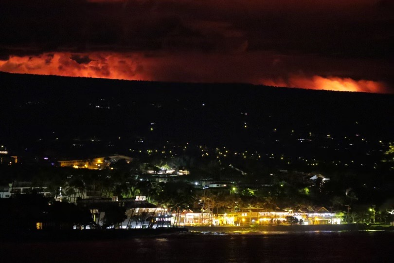
This volcanic activity caused anxiety among local residents, and tensions remained high after the USGS Hawaiian Volcano Observatory (HVO) issued a statement that the flows were not a threat to communities and people living on the west side of the island. How could that be? "We see the flows!" was the public's response.
Past eruptive behavior is an excellent guide to future activity. From past eruptions, we know that lava flows from the Southwest Rift Zone of Mauna Loa can threaten communities in a matter of hours and quickly reach the ocean.
It is the same past behavior that gave HVO the confidence to say that those flows, seen from Kona, were not a threat to folks living on the west side of the island. Let us explain.
Mauna Loa has erupted 34 times since 1843. Each eruption started in Mokuʻāweoweo, and likely the south caldera area; however, there are very few eyewitness observations of the onset of eruptions in the 19th and 20th centuries due to the great distances, high altitude, cold, and lack of water (to name a few).
Trying to sleuth the activity from geologic mapping is confounded by frequent eruptive activity, as old eruptions were covered by new eruptions, obliterating the past eruptive history.
Fortunately, there were some astute observers and intrepid adventurers who hiked to the summit for the 19th and early 20th-century eruptions. And in the late 20th century, technology (airplanes and satellites) helped us to document some of the activity.
Based on those observations, we can say with confidence that the activity in the early hours of the 2022 Mauna Loa eruption was similar to some past eruptions. Similar reports from the west side of the island—of flows descending from the south caldera region toward South Kona, as observed in 2022—also occurred in 1851, 1879, 1887, 1897, 1899, 1903, 1907, 1926, 1933, 1940, 1949, 1975, and 1984.Past eruptive behavior is an excellent guide to future activity. From past eruptions, we know that lava flows from the Southwest Rift Zone of Mauna Loa can threaten communities in a matter of hours and quickly reach the ocean.
It is the same past behavior that gave HVO the confidence to say that those flows, seen from Kona, were not a threat to folks living on the west side of the island. Let us explain.
Mauna Loa has erupted 34 times since 1843. Each eruption started in Mokuʻāweoweo, and likely the south caldera area; however, there are very few eyewitness observations of the onset of eruptions in the 19th and 20th centuries due to the great distances, high altitude, cold, and lack of water (to name a few).
Trying to sleuth the activity from geologic mapping is confounded by frequent eruptive activity, as old eruptions were covered by new eruptions, obliterating the past eruptive history.
Fortunately, there were some astute observers and intrepid adventurers who hiked to the summit for the 19th and early 20th-century eruptions. And in the late 20th century, technology (airplanes and satellites) helped us to document some of the activity.
.jpg) |
| A view of fissure 4 erupting in November of 2022 on the Northeast Rift Zone of Mauna Loa. Fissure 4 formed at approximately 7:30 p.m. On the next morning, Nov. 29, the fountains there were 5-10 m (16-33 ft) tall. USGS photo by F. Trusdell |
Flows that erupted in the south caldera region, but were not confirmed by visual observations from Kona, include the 1868, 1916, 1919, and 1950.
Flows that are visible high on Mauna Loa's west flank erupt from the south caldera region of Mauna Loa, outside the topographic depressions of the summit region. Activity in this location is easily visible from the south and west sides of the island, which can be alarming. However, none of these previous lava flows in the south caldera region, whether observed or not, traveled far enough to threaten South Kona. Thus, just because folks can see lava from the west side of the island, high on Mauna Loa's west flank, does not indicate that lava will head south or that Kona will be inundated.
In 2022, monitoring parameters clearly indicated that only the summit region was active in the initial hours, without lava propagating down the Southwest Rift Zone. This is why HVO was confident in issuing a statement that the flows were not a threat to the west side of the island.
Since the south caldera region is often active at the start of eruptions, and lava flows are common, it is important to be aware that this type of activity is normal, and it does not necessarily constitute a threat to communities on the western flank of Mauna Loa. Ultimately, we must wait until Pele decides whether the eruption will move out of the summit and south caldera to determine if it poses a threat.
Eruptions are an inevitable part of Mauna Loa's future, but the associated hazards can be anticipated by careful documenting of its past behavior as a guide to the future. Additionally, we are increasing our webcam network to include views of the south caldera and upper Southwest Rift Zone regions of Mauna Loa. In the future, we will have near real-time visual surveillance of this portion of the volcano, enhancing our existing monitoring network and aiding us in our primary mission: to issue timely and accurate warnings of hazardous volcanic activity.
 |
| USGS photo taken from Saddle Road Nov. 29, 2022, shows lava flows moving northeast downslope of Mauna Loa from the Northeast Rift Zone eruption. USGS photo by David Free |
Mauna Loa is not erupting. Its USGS Volcano Alert Level is at NORMAL.
Webcams show no signs of activity on Mauna Loa. Summit seismicity has remained at low levels over the past month. Ground deformation indicates continuing slow inflation as magma replenishes the reservoir system following the 2022 eruption. SO2 emission rates are at background levels.
Three earthquakes were reported felt in the Hawaiian Islands during the week ending Thursday: a M3.3 earthquake 7 km (4 mi) S of Volcano at 1 km (0 mi) depth on Jan. 31 at 3:43 p.m. HST, a M3.5 earthquake 7 km (4 mi) SW of Volcano at 0 km (0 mi) depth on Jan. 31 at 3:42 p.m. HST, and a M3.0 earthquake 1 km (0 mi) SW of Pāhala at 35 km (22 mi) depth on Jan. 30 at 7:58 a.m. HST.
HVO continues to closely monitor Kīlauea and Mauna Loa.
To read comments, add your own, and like this story, see facebook.com/kaucalendar. See latest print edition at kaucalendar.com, in the mail and on stands.
 | ||||
 |


_0.png)