About The Kaʻū Calendar

Saturday, August 24, 2024

Kaʻū News Briefs Aug. 24, 2024

 Tropical Storm Hone chugged along a path south of Hawai'i Island on Saturday, sending steady
rain and bands of rain onto the island overnight. Photo from NOAA
THE WORST IS YET TO COME were the predictions all day and into the evening Saturday as some steady rains and bands of rains, but little wind, came on shore in Kaʻū. 
    The center of tropical storm Hone was about 110 miles SSE OF Hilo at 7:10 p.m., according to Central Pacific Hurricane Center. Rain from the storm was already on island. The maximum sustained winds offshore at the center of the storm were 65 mph, but winds were expected to extend onto the island as the storm passes south of South Point overnight.
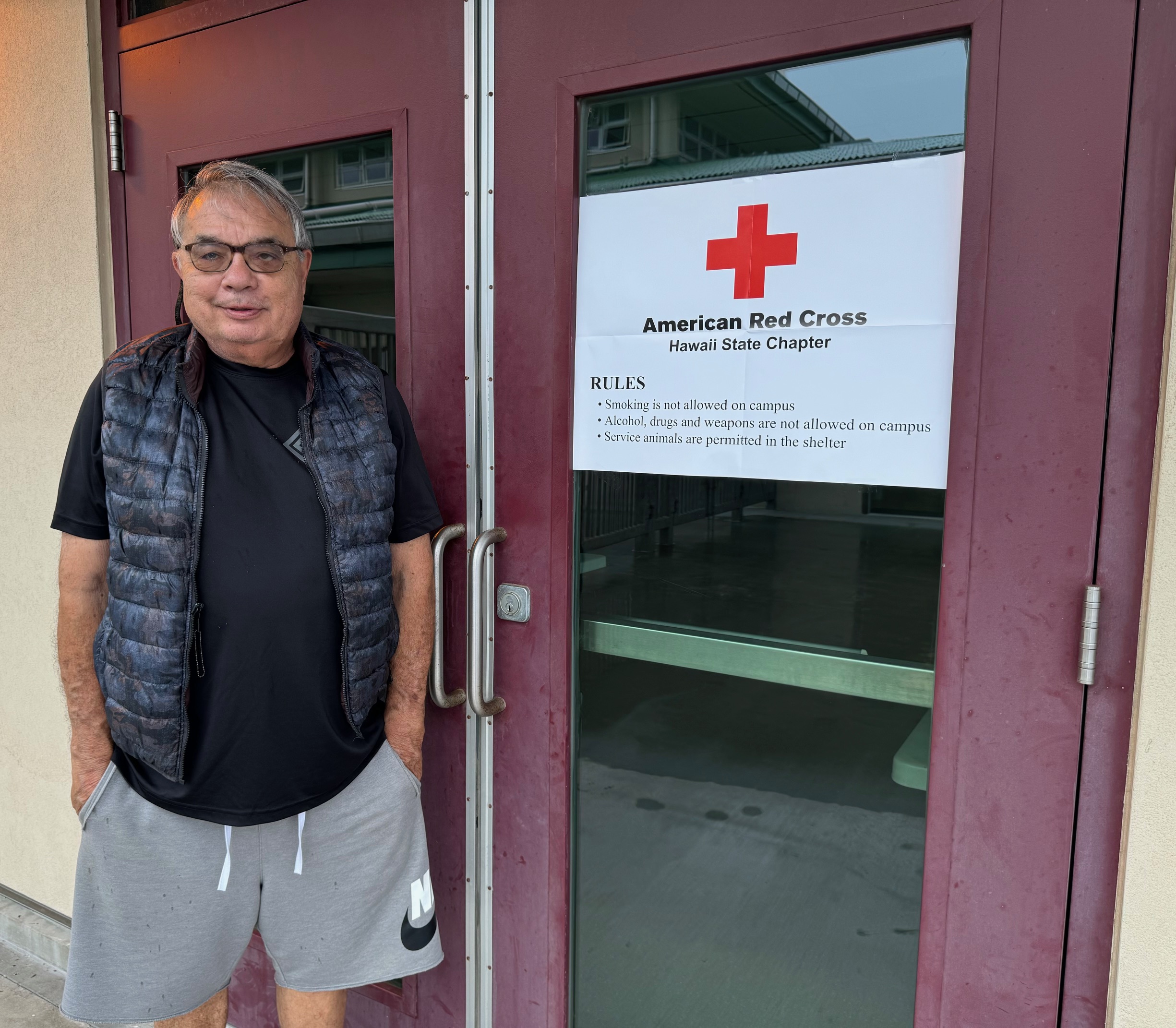
Glenn Kokubun maned the county/Red Cross
shelter in the auxiliary room to Kaʻū Herkes
District Gym. Na'alehu Elementary School cafeteria
 was also opened as a shelter. Photo by Julia Neal
A Flood Advisory listed Volcano and Hawai'i Volcanoes National Park as areas likely to experience flooding, as rain was constant in Puna, north to Hilo and Hamakua Coast. A Red Flag alert warning of possible wildfires was cancelled in the afternoon.
Some Hele On Bus Routes were cancelled as were all one way flights from Honolulu to Hilo Airport.
The County cancelled all overnight camping at Whittington and Punalu'u Beach Parks, followed by closing all county beach parks islandwide. The County opened shelters at Herkes Kaʻū District Gym and Nāʻālehu Elementary School Cafeteria.

COASTAL AND MAUNA LOA SUMMIT BACKCOUNTRY HIKING AND CAMPING is prohibited in Hawai'i Volcanoes National Park until further notice. The Park made the announcement Saturday morning in light of the National Weather Service issuing a Tropical Storm Warning for Hawaiʻi Island. 
    "Because this includes a possibility of tropical storm force winds, Hawaiʻi Volcanoes National Park has closed the coastal and Mauna Loa summit backcountry areas to both day hiking and overnight camping.
     "The park will continue to monitor the storm conditions and any damage that follows and will reopen the backcountry when it is safe to do so. Park visitors are urged to check the weather https://www.nhc.noaa.gov/?cpac and the park website for any closure or hazard alerts at www.nps.gov/hawaiivolcanoes. 

To read comments, add your own, and like this story, see facebook.com/kaucalendar. See upcoming events, print edition and archive at kaunews.com. Support this news service with advertising at kaunews.com. 7,500 copies in the mail and on stands.

Trojans Football Roster
WITH TROPICAL STORM HONE ON ITS WAY, THE TROJAN'S FIRST FOOTBALL GAME OF THE YEAR WAS CANCELLED Saturday, on the home field, reports Kaʻū High Athletic Director Jaime Guerpo. He said that when the call came from Department of Education to cancel all of Saturday's high school football games islandwide, the Trojans were eating breakfast at the school cafeteria before their warmup. Down in Puna, the principal of Pahoa High called off the bus trip for the visiting Pahoa Daggers just before they left their campus to head out to Ka'u.
    "The Trojan team is really disappointed but looks forward to next weekend's game and a rematch with Pahoa," said Guerpo.
     The game was to have been the launch of the expanded Trojan cheerleading squad, which numbers more than 20. It is under the direction of Carma Hanshew.
    
To read comments, add your own, and like this story, see facebook.com/kaucalendar. See upcoming events, print edition and archive at kaunews.com. Support this news service with advertising at kaunews.com. 7,500 copies in the mail and on stands.

May be an image of text

VOLCANIC TREMOR OR DISTANT EARTHQUAKE? That's the title of this week's Volcano Watch written by U.S. Geological Survey Hawaiian Volcano Observatory scientists and affiliates:
    The Island of Hawaiʻi is one of the most seismically active areas in the world, producing thousands of earthquakes every year. It also commonly produces a signal called tremor that can originate from the volcanic system.
    Tremor is characterized by slowly emerging seismic waves which may last for minutes to many days when there are ongoing eruptions. It is important to identify tremor because this signal can be associated with fluid movement, which can sometimes indicate an increased chance of eruption. However, tremor is often difficult to locate because the waves slowly emerge from the background noise and can persist for minutes to weeks or even years—shallow tremor at Kīlauea or Mauna Loa is often directly associated with ongoing eruptive activity.
Color plots of seismic data

Example waveforms showing a T-phase arriving from the M7.4 Chile earthquake on July 19, 2024 (left).  This T-phase event is compared to a local tremor burst deep beneath Pāhala on July 30, 2024 (right). The plots show time for several stations in the HVO network. The T-phase moves more slowly across the network which is represented by systematic delays in the time from the top to the bottom of the left plots on the figure. The plots on the right side of the figure shows the waveforms coming in at about the same time on several stations; this occurs because the Pāhala event is deeper beneath the volcano. USGS image

    In contrast, earthquakes usually have sharp onsets which are easy to see. The time that an earthquake signal appears at the many stations that make up the USGS Hawaiian Volcano Observatory (HVO) seismic network can be used to find the earthquake's location. Instead, the location for tremor bursts is often estimated by looking at the signal size (or seismic amplitude) at multiple seismic stations and then determining the approximate position and depth.
    As an example, shallow tremor bursts at Mauna Loa summit might have strong seismic amplitudes at stations near the summit of Mauna Loa, but very weak signals by the time the signal arrives at the Kīlauea seismic stations. By contrast, a tremor burst deep below Pāhala may have almost the same seismic amplitudes on several stations near Pāhala, and only to become weak at seismic stations in Kona, or Hilo.
Permanent seismic stations and temporary nodal locations keep track of activity in Ka'u.
USGS map
    It is important to note that not all tremor-like signals are related to volcanic activity and in some cases may not be from the Island of Hawaiʻi. A large magnitude-7.4 earthquake deep beneath Chile on July 19 at 3:50 p.m. HST produced strong ground shaking in Chile and was also recorded on the HVO seismic network.
    This earthquake also produced a strong hydroacoustic signal (a sound wave traveling through water)— called the T-phase—which was recorded throughout the Pacific basin. T-phases are very different from a tsunami wave and are not hazardous to people. They move at a speed of almost 1.5 kilometers per second (about 3,355 mph) and so would take just under 2 hours to get from Chile to the State of Hawai'i.
    In this case the wave is transmitted through the ocean predominantly within a horizonal layer called the Sound Fixing and Ranging (SOFAR) channel, which tends to efficiently trap or guide hydroacoustic sound waves. When the T-phase reaches the coast in the State of Hawaii, its energy is converted back into a seismic signal that looks remarkably like local volcanic tremor on the HVO seismic network.
    Because HVO is always vigilantly monitoring seismic signals, HVO scientists often need to distinguish between local volcanic tremor and the T-phase from a distant earthquake. The figure here shows an example of local tremor burst deep beneath Pāhala at 4:13 p.m. HST on July 30, 2024. By comparing this local tremor burst to the earlier T-phase event from Chile on July 19, we see that the T-phase event has arrivals that are spread out in time across the HVO seismic network—a result of the slower speed of the acoustic waves in the water. By contrast, the deep volcanic tremor beneath Pāhala arrives at the different HVO stations at about the same time—a result of the local source and faster wave speeds found for basaltic rocks.
    HVO scientists can distinguish local tremors from distant earthquakes by assessing arrival times for signals and evaluating their amplitudes. They can further confirm that the observed signal is a T-phase by looking for large events in the global earthquake catalog. This seismic sleuthing is one of the many facets of volcano monitoring in Hawai'i.

Volcano Activity Updates
    Kīlauea is not erupting. Its USGS Volcano Alert level is ADVISORY. Seismic activity and ground deformation continues at Kīlauea's summit and upper-to-middle East Rift Zone, with another intrusive event near Pauahi Crater from August 19-20. Over the week ending Thursday, about 800 earthquakes were detected beneath Kīlauea's upper East Rift Zone and about 100 events were detected between Maunaulu and Puʻuʻōʻō in the middle portion of the East Rift Zone within Hawaiʻi Volcanoes National Park. Over the past week, Kīlauea's summit and middle East Rift Zone showed slow inflation, followed by slow deflation during the intrusive event. Since then, there has been relatively little ground deformation
recorded in these regions. Unrest may continue to wax and wane with changes to the input of magma in these areas; changes can occur quickly, as can the potential for eruption.
    Mauna Loa is not erupting. Its USGS Volcano Alert Level is at NORMAL. 
    Fourteen earthquakes were reported felt in the Hawaiian Islands during the week ending Thursday, Those above magnitude-3 were: a M4.7 earthquake 15 km (9 mi) S of Fern Forest at 6 km (4 mi) depth on August 22 at 12:52 a.m. HST, a M3.4 earthquake 6 km (3 mi) S of Volcano at 0 km (0 mi) depth on August 20 at 9:22 a.m. HST, a M3.2 earthquake 8 km (4 mi) S of Volcano at 0 km (0 mi) depth on August 20 at 7:22 a.m. HST, a M3.8 earthquake 11 km (6 mi) NE of Pāhala at 31 km (19 mi) depth on August 20 at 5:32 a.m. HST, a M3.9 earthquake 30 km (18 mi) WNW of Hawaiian Ocean View at 11 km (7 mi) depth on August 20 at 3:52 a.m. HST, and a M3.2 earthquake 6 km (3 mi) S of Volcano at 1 km (0 mi) depth on August 20 at 2:46 a.m. HST.

To read comments, add your own, and like this story, see facebook.com/kaucalendar. See upcoming events, print edition and archive at kaunews.com. Support this news service with advertising at kaunews.com. 7,500 copies in the mail and on stands.


Friday, August 23, 2024

Kaʻū News Briefs Aug. 23, 2024

.
Trojan football team roster.
WITH TROPICAL STORM HONE ON ITS WAY, THE FIRST TROJAN HOME FOOTBALL GAME OF THE YEAR is scheduled to go forward at the ball field in Pahala at 1 p.m., Saturday, hosting Pahoa Daggers, according to Athletic Director Jaime Guerpo. Head coach is Connor Norton. Assistant Coach is Mark Peters. Coaching staff includes Greg Rush, Ray Mayzack, Duane Pua, Time Drafaul, Ted Blanco and Walter Parada. Athletic Trainer is Moses Whitcomb.
     The game features a record number of Trojan cheerleaders, more than 20, who have been practicing live and online. Cheerleading Coach is Carma Hanshaw.

To read comments, add your own, and like this story, see facebook.com/kaucalendar. See upcoming events, print edition and archive at kaunews.com. Support this news service with advertising at kaunews.com. 7,500 copies in the mail and on stands.

TROPICAL STORM HONE WAS located about 380 miles east-southeast of Hilo at 7:45 p.m. Friday, moving west around 16 mph. Note that the wind map shows that the earliest tropical-storm-force winds could arrive Saturday morning, The map of Hone's path shows its center going by Hawai'i Island between Saturday night and early Sunday morning.
    The Alert Level was raised to Warning on Friday afternoon, with the earliest possible winds coming in Saturday between 8 a.m. and 2 p.m. and the center of the storm passing by Saturday night, south of the island. Central Pacific Hurricane Center report predicts 65 mph to 75 mph winds at her center at the time Hone goes by South Point. Wind predictions for Kaʻū are 40 to 60 mph. The report at 5 p.m. Saturday also says conditions could allow strengthening and that Hone could become a hurricane.
    The U.S. Air Force Reserve Hurricane Hunter aircraft sampled Hone from Friday morning into early afternoon and provided valuable data, according to the Central Pacific Hurricane Center report:
    "In spite of its lack of convection, Hone maintained a well-developed low cloud field and remained surprisingly intense through the morning, well above Dvorak inputsfrom the fix agencies. Late this afternoon, deep convection is redeveloping near the center as winds aloft ease. The latest data from the Hurricane Hunters came in just before 00Z and showed maximum sustained winds holding at 45 kt and a minimum sea level pressure of 1000 mb. Given the appearance of Hone, these values will be used for the initial intensity. The initial motion is unchanged at 280/14. This general motion toward slightly north of due west will continue during the next several days as Hone is steered by a deep subtropical ridge to the north.
    "However, some slowing of the forward motion is anticipated as the deep ridge to the north of Hone weakens slightly. Along this track, Hone will be passing near or just south of the state late Saturday into early Sunday, which necessitates the issuance of a Tropical Storm Warning for the Big Island of Hawai'i.

    "By the middle of next week, Hone will likely become increasinglyshallow as vertical wind shear increases, allowing the low level trade wind flow to steer the system toward the west. The official forecast track is nearly identical to the previous advisory, and closely follows the tightly clustered consensus guidance near the TVCN.
    "Hone has a window for intensification during the next 36 to 48 hours. Easterly winds aloft, which have inhibited outflow in all but the south and southwest quadrants, will relax tonight and Saturday as a weakness develops in the upper level ridge north of the cyclone. Sea surface temperatures will remain around 26-27C, which will be sufficient for intensification, possibly to hurricane strength, late Saturday or early Sunday.
    "Late Sunday and Monday, west to northwest vertical wind shear will increase sharply, which should result in steady weakening. The intensity forecast remains on the higher side of the guidance envelope near the HCCA and slightly higher than the IVCN. Beyond 48 hours, the forecast closely follows the IVCN."

KEY MESSAGES:
1. There is the potential for excessive rainfall and flash flooding on portions of the Big Island of Hawaii starting later Saturday and continuing through Sunday as a large area of moisture associated with Hone moves over parts of the Hawaiian Islands. The heaviest rainfall will likely occur over windward and southeast facing slopes.
2. Tropical storm conditions are possible on the Big Island later Saturday into Sunday. Winds are expected to be strongest where they blow downslope from higher terrain, over headlands, and through passes.
3. Swell generated by Hone is expected to reach the Hawaiian islands Saturday night into Sunday. This swell could cause life-threatening surf and rip currents. Listen for later advisories and possible warnings from the National Weather Service

CRITICAL CONDITIONS THAT COULD LEAD TO WILDFIRES will likely come with Tropical Storm Hone on Saturday. Winds from an offshore hurricane last year played a part in the Lahaina fire disaster.
Hawai'i Fire Department was already contending with a wildfire between Waimea and Waikoloa on Friday evening, unrelated to the storm but subject to winds of Hone should it reach there while the fire is active.
Hawai'i County Civil Defense reports the National Weather Service issuance of a Red Flag Warning for Saturday in Kaʻū, the interior of Hawai'i Island, as well as North and South Kohala.
   A Red Flag Warning means that:
    Critical conditions of strong, gusty trade winds, dry fuel, low relative-humidity, and warm temperatures could produce extreme fire behavior.
    Any fires that develop will likely rapidly spread and be difficult to control.
    Due to these conditions, the following actions are recommended:
    Avoid any activity that involves using open flames such as grilling and camp fires.
    Do not park cars on dry grass after a trip.

To read comments, add your own, and like this story, see facebook.com/kaucalendar. See upcoming events, print edition and archive at kaunews.com. Support this news service with advertising at kaunews.com. 7,500 copies in the mail and on stands.


HAWAI'I COUNTY'S GENERAL PLAN 2045 IS CLOSE TO BEING FINALIZED with new updates added. They include a    A Community Meeting on the new General Plan Final Draft will be held on Thursday, Sept. 19 at 5 p.m. in the Kaʻū District Gym Multi-Purpose Room: 96-1219 Kamani St, Pāhala, The General Plan is the sister plan to the Kaʻū Community Development Plan and covers the entire island.
   Ahead of the Community Meeting, Public Workshops will be held on:
   Wednesday, Aug. 28 at West Hawaiʻi Civic Center, Building A from 2 p.m. to 4 p.m.
   Thursday, Aug. 29 Arc of Hilo, 1099 Waianuenue Ave from 2 p.m. to 4 p.m.
   Thursday, Sept. 5 with an Online Webinar Workshop from 5 p.m. to 7p.m. (Registration link TBD)
    Additional Community Meetings will be held around the island. Public comments for this phase of developing the Hawai'i County General Plan are due Thursday, Sept. 26. giving the public 21 days after the last workshop to share comments with the Planning Director. Once this period ends, the Final Recommended Draft in its current form and all public comments will be packaged and submitted to the Windward and Leeward Planning Commissions, which will hold public hearings in November. The County Council will hold public hearings next April before finalizing the General Plan.

To read comments, add your own, and like this story, see facebook.com/kaucalendar. See upcoming events, print edition and archive at kaunews.com. Support this news service with advertising at kaunews.com. 7,500 copies in the mail and on stands.


Thursday, August 22, 2024

Kaʻū News Briefs Aug. 22, 2024


TROPICAL STORM HONE WAS NOT NAMED HECTOR because she made it to the Central Pacific before becoming a Tropical Storm on Thursday. Central Pacific Hurricane Center issued a Tropical Storm Watch for Hawai'i Island. Hawai'i County Civil Defense explained that a Tropical Storm Watch is issued when tropical storm conditions are possible within 48 hours.
    Civil Defense urges the following: 
    "Please take this time to review your emergency plans and prepare your emergency kit.
    Prepare your property for heavy rains and flooding conditions.
    You will be informed as conditions change."
    The 11 p.m. forecast from Hawai'i Hurricane Center says:
    The initial intensity of Hone has been increased slightly to 40 knots with this advisory. Air Force Reserve Reconnaissance Aircraft will give us a better idea of the intensity, structure, and size of Hone
Friday morning. The initial motion for this advisory is set at 280/12 knots. This general motion is expected to continue during the next several days as Hone is steered by a large subtropical ridge to the north.
    A decrease in forward speed and a slight turn towards the west-northwest is expected during the first half of next week as a weakness develops in the subtropical ridge north of the system. The official forecast track lies nearly on top of the track from the previous advisory, and closely follows the tightly clustered consensus guidance.
    Environmental conditions will change little during the next few days. Hone will remain in an environment characterized by low to moderate vertical wind shear, sea surface temperatures around 26 to 27C, and sufficient deep layer moisture. This is expected to support gradual strengthening of the system as it moves in a general westward direction during the next couple of days.
    It appears that there is a window for further intensification Sunday through Tuesday as the system tracks south of the Hawaiian Islands. Hone will be moving into an area with sea surface temperatures of 27C and higher ocean heat content, while the westerly vertical wind shear remains at light to moderate levels. This could allow Hone to reach Hurricane strength and the current official forecast reflects this. Beyond day 4, westerly vertical wind shear increases sharply to between 30 and 35 knots, and some drier mid-level air appears to begin entraining into the system. This should result in a weakening trend by day 5.
    
KEY MESSAGES:
1. There is the potential for excessive rainfall and flash flooding on portions of the Big Island starting later Saturday, continuing through Sunday and lingering into Monday as a large area of moisture associated with Hone. The heaviest rainfall will likely occur over windward and southeast facing slopes.

2. Tropical storm conditions are possible on the Big Island later Saturday into Sunday. Winds are expected to be strongest where they blow downslope from higher terrain, over headlands, and through passes.

3. Swell generated by Hone is expected to reach the Hawaiian islands Saturday night into Sunday. This swell could cause life-threatening surf and rip currents. Listen for later advisories and possible warnings from the National Weather Service.
    While Hone comes this way, Hurricane Gilma is expected to weaken below Tropical Storm intensity before traveling near Hawai'i and could completely dissipate without reaching Hawaiian waters, according to the NOAA forecast.

To read comments, add your own, and like this story, see facebook.com/kaucalendar. See upcoming events, print edition and archive at kaunews.com. Support this news service with advertising at kaunews.com. 7,500 copies in the mail and on stands.

Lady Trojan Kiara Ortega-Oliveira digs a spike during Tuesday night's BIIF volleyball match against the Lady Cougars at Keaau High School with Trojans Coach Josh Ortega in the background. Photo by Tim Wright

Kaʻū 's Zia Rae Wroblewski taps the ball over during Tuesday night's BIIF
 winning volleyball match at Keaau High School. Photo by Tim Wright

KA'U LADY TROJANS VOLLEYBALL TEAM WON  TWO MATCHES, THIS WEEK BEATING CHRISTIAN LIBERTY ACADEMY at home on Thursday in three straight games of varsity play, 25-6, 25-14, and 25-12. The Trojans beat Kea'au on Tuesday, 25-13, 23-25, 25-16, 27-25.
    Coach is Josh Ortega, Assistant Coach is Sarah Ortega, Trainer Moses Whitcomb and Athletic Director is Jaime Guerpo.
     The varsity team is comprised of Mckenzie Decoito, Leahi Kaupu, Jezerie Rose Nurial-Dacalio, Kiara Ortrega-Oliveira, Jazmyn Navarro, Aubrey Delos Santos-Graig, Aljshae Barrios, CaLiya Silva-Kamei and Zia Rae Wroblewski.
    The JV team is comprised of Deijah Cabanilla-Nogales, Lily Dacalio, Christy Girl Grohs, Megan Pierpont, Kalesha Hashimoto, Alazae Forcum, Wailea Kainoa Haili-Barawis and Dhaylee Cabreros.


Leahi Kaupu spikes Lady Cougars at Keaau High School. Photo by Tim Wright

To read comments, add your own, and like this story, see facebook.com/kaucalendar. See upcoming events, print edition and archive at kaunews.com. Support this news service with advertising at kaunews.com. 7,500 copies in the mail and on stands.