 |
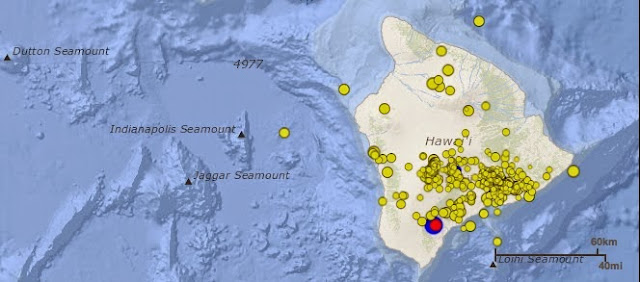
| The U.S. Geological Survey registered a 4.5 magnitude earthquake this morning with aftershocks. Image from Hawaiian Volcano Observatory |
A map showing its location is posted on the HVO website at http://hvo.wr.usgs.gov/seismic/volcweb/earthquakes/.
The earthquake was widely felt on the Island of Hawaiʻi. The USGS Did you feel it? Web site (http://earthquake.usgs.gov/eqcenter/dyfi/) received over 70 felt reports within an hour of the earthquake. Light shaking (Intensity IV) has been reported across the island. At these shaking intensities, damage to buildings or structures is not expected, HVO reported.
Three aftershocks (magnitudes 1.6, 1.5, 1.4) of the earthquake were recorded as of 3:30 a.m., HST. Additional aftershocks are possible and could be felt.
Over the past 30 years, the area north of Nāʻālehu has experienced six earthquakes, including today's event, with magnitudes greater than 4.0 and at depths of 5–13 km (3.1–8.1 mi). This area of Kaʻū is a seismically active region where a magnitude-6.2 earthquake occurred in 1919. Areas adjacent to this morning’s event experienced earthquakes of magnitudes 6.0, 7.1, and 7.9 in 1868.
According to HVO, the earthquake caused no detectable changes in Kīlauea Volcano's ongoing eruptions, on Mauna Loa, or at other active volcanoes on the Island of Hawaiʻi. A magnitude-3.1 earthquake that occurred in Kīlauea Caldera about one minute before the magnitude-4.5 earthquake was unrelated to the Nāʻālehu event.
For information on recent earthquakes in Hawai`i and eruption updates, visit the USGS Hawaiian Volcano Observatory website at http://hvo.wr.usgs.gov.
To comment on or like this story, go to facebook.com/kaucalendar.
 |
| Tutu and Me staff members are required to spend cultural days to learn more about the community, and recently visited Hawai`i Volcanoes National Park. |
TUTU AND ME, the traveling preschool sponsored by Partners in Development Foundation, has opened enrollment for keiki ages birth through five for the 2015-2016 school year. This follows a successful 2014-2015 program plus volunteer work by staff members in the larger Ka`u community, said Betty Clark, Site Manger for the southern communities of the Hawai`i Island.
She pointed out that all staff members are required to volunteer in the community. Community contributions have included a beach clean-up, volunteering at Pahala and Na`alehu Elementary Schools, and helping 'O Ka`u Kakou with Senior Bingo.
Staff members are also required to spend time learning about culture. These kumu a'o days have been spent at Hawai`i Volcanoes National Park, the Merrie Monarch Festival Craft Fair and a full day learning Hawaiian mele, lau hala weaving and games, sponsored by the Hawaiian Civic Club of Ka'u and taught by Zachary Bernardi and Allen Stafford.
The Tutu and Me staff recently led a keiki and family visit to the Kipuka Pua`ulu Bird Park and trail in the National Park.
To register for Tutu and Me, call Clark at 929-8571. Email her at eclark@pidfoundation.org and see www.pidfoundation.org.
To comment on or like this story, go to facebook.com/kaucalendar.
 |
| The interactive map shows the crop when one clicks on a farm, like this Ka`u Coffee farm near Pahala. Map from Agricultural Baseline Project |
Those interested are able to see types of crops on the areas mapped in Ka`u, from coffee to macadamia, truck crops, mango orchards and biomass tree farms. The map can be enlarged to see specific fields. Click on them and the crop type is revealed.
The draft will be onine until mide June and the final report and digital layer is expected to be completed by the end of October. Project director is Jeff Melrose.
Melrose is working with the University of Hawai`i-Hilo Spacial Data Analysis and Visualization Lab. Contact him at jmelrose@hawaii.edu.
The link to the ag footprint map is http://geodata.sdal.hilo.hawaii.edu/statewideagbaseline/map.html
To comment on or like this story, go to facebook.com/kaucalendar.
HAWAI`I CENTER FOR FOOD SAFETY has released an abridged edition of its new report, contending that pesticides are threatening the health of residents, particularly when used near schools, homes and hospitals. The organization calls for more oversight and public notice of pesticide use and states that pesticides may be damaging to food security, human health and health of the environment. The report is called Pesticides in Paradise: Hawai`'s Health & Environment at Risk. Hawai`i Center for Food Safety also takes up the GMO issue and contends that GMO agriculture uses more pesticides than other ag and therefore puts the public at higher risk.


Hawai`i Crop Improvement Association executive director Bennette Misalucha, issued a statement saying Center for Food Safety. "is advancing its true mission - using fear and pseudoscience to raise money and perpetuate misinformation."
Center for Food Safety, in its press release, states that Pesticides in Paradise "delivers a comprehensive review of published scientific and medical research examining the threats pesticides used in Hawai‘i pose to public health, especially the risk to pregnant women and young children. The report also considers the severe impacts of pesticides on Hawai‘i’s ecosystems and the challenges the growing seed industry pose to local food self-sufficiency."
 Focusing on GMO, the statement says that "Alarmingly, the GE (Genetically Engineered) seed industry’s footprint on the Hawaiian Islands (24,700 acres) is 72 percent of the total area planted to food crops other than sugarcane or pineapple (34,400 acres). Since 1987 Hawai‘i has hosted more cumulative field trials (3,243) than any other state. In 2014 alone, 178 different GE field tests were conducted on over 1,381 sites in Hawai’i (vs. only 175 sites in California). Herbicide-resistance was the most frequently tested trait in GE crop field tests in Hawai‘i over the past five years. This means that plants genetically engineered in Hawai‘i, by and large, are engineered to resist greater and greater application of herbicides."
Ashley Lukens, PhD, Director of Hawai`i Center for Food Safety, said, “We frequently hear that genetic engineering has nothing to do with pesticides, and that pesticides do not have an impact on our environmental and public health, but this comprehensive review tells a very different story."
The report contends that "one agrochemical company applied 90 different pesticide formulations containing 63 different active ingredients on Kaua‘i from just 2007 to 2012, and sprayed on two-thirds, or 65 percent, of the days of the year. Some of the most dangerous restricted use pesticides on the market are being used year round, including atrazine, chlorpyrifos, and paraquat."
According to county planner Ron Whitmore, the purpose of these discussions is to explore specific topics of interest in-depth. "It is an opportunity for community members to expand their understanding of the CDP and the rationale behind particular strategies. It is also an opportunity to provide new information, suggest alternative CDP strategies, and propose additional areas of analysis." He stated that the discussions are "designed to be friendly, fact-driven, and learning-oriented. They are not formal meetings, opportunities to testify, or debates. Participants should come with an open mind and a sincere interest in finding the most effective CDP strategies to achieve the community’s objectives."
Focusing on GMO, the statement says that "Alarmingly, the GE (Genetically Engineered) seed industry’s footprint on the Hawaiian Islands (24,700 acres) is 72 percent of the total area planted to food crops other than sugarcane or pineapple (34,400 acres). Since 1987 Hawai‘i has hosted more cumulative field trials (3,243) than any other state. In 2014 alone, 178 different GE field tests were conducted on over 1,381 sites in Hawai’i (vs. only 175 sites in California). Herbicide-resistance was the most frequently tested trait in GE crop field tests in Hawai‘i over the past five years. This means that plants genetically engineered in Hawai‘i, by and large, are engineered to resist greater and greater application of herbicides."Ashley Lukens, PhD, Director of Hawai`i Center for Food Safety, said, “We frequently hear that genetic engineering has nothing to do with pesticides, and that pesticides do not have an impact on our environmental and public health, but this comprehensive review tells a very different story."
The report contends that "one agrochemical company applied 90 different pesticide formulations containing 63 different active ingredients on Kaua‘i from just 2007 to 2012, and sprayed on two-thirds, or 65 percent, of the days of the year. Some of the most dangerous restricted use pesticides on the market are being used year round, including atrazine, chlorpyrifos, and paraquat."
The full report is expected to be released in June. Download the abridged report and see more at www.centerforfoodsafety.org.
AGRICULTURE AND COASTAL MANAGEMENT in Ka`u are topics of focused discussions today at Na`alehu Community Center. Ka`u Community Development Plan staff members speak with Ka`u residents about ag at 9 a.m. and coastal management at 1 p.m. According to county planner Ron Whitmore, the purpose of these discussions is to explore specific topics of interest in-depth. "It is an opportunity for community members to expand their understanding of the CDP and the rationale behind particular strategies. It is also an opportunity to provide new information, suggest alternative CDP strategies, and propose additional areas of analysis." He stated that the discussions are "designed to be friendly, fact-driven, and learning-oriented. They are not formal meetings, opportunities to testify, or debates. Participants should come with an open mind and a sincere interest in finding the most effective CDP strategies to achieve the community’s objectives."
 |
| The future of Punalu`u, where people gather and hawksbill turtles nest, is one of of the topics expected to be discussed at this afternoon's meeting on coastal management at 1 p.m., Na`alehu Cmmunity Center. Photo by Dave Berry |
During the morning session about agriculture, the plan is to cover sub-topics like: ag zones and permitted uses, farm land preservation, infrastructure improvements to expand agriculture (eg, water, energy, amendments), and barriers farmers face like land tenure, diversification, and value chain development.
During the afternoon session about coastal management, sub-topics for discussion are expected to include: shoreline setbacks, public access & trails, South Point management, resort development, and the future of Punaluʻu.
County planners familiar with these issues will be on hand and equipped with background material and geographic information systems (GIS) to support the discussion and do “on the fly” analysis.
Participants’ questions, comments, and suggestions will be documented. The CDP Planning Team will use outputs of the discussion to do additional analysis, refine the CDP rationale, and/or recommend CDP revisions, Whitmore stated.
A similar discussion about potential development in Discovery Harbour is scheduled for this coming Tuesday, May 12, at 10 a.m.. Focused discussions about other topics can also be scheduled. See kaucdp.info or call 961-8137 for more information.
THROUGH THE ARTIST'S' EYE is an invitational exhibition at Volcano Art Center Gallery through May 31, focusing on native plants, animals and minerals found in Hawai`i Volcanoes National Park.
To comment on or like this story, go to facebook.com/kaucalendar.
SUPPORT OUR SPONSORS AT PAHALAPLANTATIONCOTTAGES.COM AND KAUCOFFEEMILL.COM. KA`U COFFEE MILL IS OPEN SEVEN DAYS A WEEK.
