 |
| Ka`u Democrats sign in to be among those voting in Hawai`i's Preferential Preference Poll yesterday. Photos by Ron Johnson |
AS KA`U GOES, SO GOES THE STATE. That’s what happened at yesterday’s Democratic Presidential Preference Poll, when Vermont Sen. Bernie Sanders became Hawai`i Democrats’ choice to run for President. Statewide, Sanders took 70 percent of the vote, compared to 30 percent for former New York Senator and Secretary of State Hillary Clinton.
Sanders received majorities of over 80 percent in all Ka`u precincts and Volcano. In Ocean View’s precinct 05-02, Sanders received 84 percent, or 145 votes, compared to Clinton’s 28. For Na`alehu’s precinct 05-01, the final was 105-20, also 84 percent. Pahala Democrats in precinct 03-07 went 19-4, or 83 percent, for Sanders. Volcano followed the same path, with Sanders winning 82 percent at 150-34.
 |
| Ka`u's state Rep. and Democratic District Rep. Richard Creagan helped guide proceedings at yesterday's meeting. |
Hawai`i Democratic Party reported that 17 of Hawai`i’s delegates for the state convention go to Sanders, and Clinton receives eight. Delegates ultimately decide who the state endorses as the presidential candidate.
The campaign group called “Bernie (not the Billionaires)” issued a statement from Sanders after the Hawai`i win: “I want to thank the people of Hawai`i for their strong support and for turning out in huge numbers for Saturday’s caucuses. Nobody should have any doubt that this campaign has extraordinary momentum and that we have a path toward victory. In state after state, our grassroots effort has taken on the entire political establishment. We have taken on the senators and the governors and the mayors and the members of Congress. Our political revolution is the best chance we have to keep Donald Trump or any other Republican out of the White House.”
 |
| Stephanie Ohigashi |
“Today’s turnout is a real testament to the hard work and commitment of the Sanders and Clinton campaigns and the engagement of Hawai`i Democrats in the presidential process,” state party Chair Stephanie Ohigashi said. “We saw turnout today reminiscent of 2008 when Hawai`i Democrats broke all records in the contest between Barack Obama and Hillary Clinton.
“I would like to thank all of the volunteers who worked so hard to make to make today successful. From Pahala to Kaumakani, the Democratic Party volunteers and the Presidential campaign representatives demonstrated the very best of the Democratic Party of Hawai`i.”
Official results will be certified by the Democratic Party of Hawai`i State Central Committee within 20 days.
To read comments, add your own, and like this story, see facebook.com/kaucalendar.
Official results will be certified by the Democratic Party of Hawai`i State Central Committee within 20 days.
To read comments, add your own, and like this story, see facebook.com/kaucalendar.
 |
| This whale was sighted off Punalu`u in 2015. Photo by Joe Garza |
MORE THAN 403 VOLUNTEERS gathered data from the shores of Hawai`i Island, O`ahu and Kaua`i yesterday during the third and final event of the 2016 Hawaiian Islands Humpback Whale National Marine Sanctuary Ocean Count.
Ocean Count serves to promote public awareness about humpback whales, the sanctuary and shore-based whale watching opportunities. The count is conducted three times per year during peak whale season and provides a snapshot of humpback whales sightings from the shoreline. Participants tally humpback whale sightings and document the animals’ surface behavior during the survey.
Volunteers collected data from 50 sites statewide yesterday. A total of 94 whale sightings were seen during the 9 a.m. to 9:15 a.m. time period, the most of any time period throughout the day’s count. Weather conditions were ideal for viewing humpback whales, but there were very few whales sighted on all three islands.
Preliminary data detailing whale sightings by site location are available at
http://www.sanctuaryoceancount.org/resources/. Additional information is available at http://hawaiihumpbackwhale.noaa.gov.
To read comments, add your own, and like this story, see facebook.com/kaucalendar.
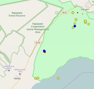 |
| An earthquake of similar magnitude struck earlier in the same area as the 10:38 a.m. quake, shown as a red dot. Other smaller quakes are not shown. Map from USGS/HVO |
A 2.0 EARTHQUAKE sent dogs diving for cover and left them shaking this morning in Pahala but was barely felt by humans. The micro quake at 10:38 a.m. Easter Sunday was centered 8.8 miles east-northeast of Pahala, makai of Hwy 11 to Volcano. The location is the site of a cluster of quakes in recent days.
To read comments, add your own, and like this story, see facebook.com/kaucalendar.
HAWAIIAN VOLCANO OBSERVATORY scientists solve the puzzle of Ka`u’s Ninole Hills in the current issue of Volcano Watch.
“For a long time, geologists were perplexed about the formation of the Ninole Hills and what they represented,” the article states. “The steep sides of the heavily vegetated hills are cut with canyons caused by thousands of years of erosion. Through age dating of the rocks, the hills were estimated to be approximately 125,000 years old.
“Several theories have been put forward to explain the formation of the Ninole Hills. According to one, they are the remnants of an older summit of Mauna Loa or its predecessor volcano, Mohokea. In another theory, faulting and landslides are thought to have formed the hills.
“Recent studies have proposed hypotheses about the Ninole Hills once being the site of active volcanism. Based on regional gravity data, one study suggested the existence of a previously unrecognized rift zone extending south of Mauna Loa’s summit toward the hills. Seismic studies suggested that the Ninole Hills might be a failed rift zone, extending from Mauna Loa’s summit, through the hills and past the coastline toward Pu`u`omahana (Green Sands).
“In 2013, USGS scientists and colleagues from academia embarked on a project using microgravity surveys to understand the origin of the Ninole Hills and to distinguish among competing hypotheses. We chose microgravity because each of the proposed mechanisms for the formation of the Ninole Hills should produce distinct gravitational signatures due to differences in subsurface structure and/or modification.
 |
| HVO scientists believe Ka`u's Ninole Hills are part of a failed rift zone that existed prior to Mauna Loa's current Southwest Rift Zone. Map from USGS/HVO |
“Measuring gravity helps scientists understand the types of rocks that might underlie the area. Using a device called a gravimeter, scientists can measure the amount of gravitational pull on a certain area.
“Gravitational pull varies depending upon location on the Earth’s surface, as well as the types of rock that make up the area. Lava rocks – for example, those from flows near Kalapana – are low-density and, thus, have lower gravity values. The rift zones and summits of volcanoes contain denser rocks due to repeated intrusions that result in magma cooling below ground, so they have a higher gravity signature.
“With the microgravity survey, we found an elongate, northeast-to-southwest positive, or high, gravity anomaly in the region of the hills. If the Ninole Hills represent slump blocks and landslide scarps, they should generate a gravitational low, because lava flows and faulted surfaces are characteristically low-density. Therefore, this hypothesis is not consistent with the data.
“If the Ninole Hills are the location of the summit area of an older volcano, the anticipated gravity signal would be circular and centered above a dense intrusive complex. But the microgravity data instead show an elongate intrusive complex.
“The Ninole Hills and Mauna Loa lava flows show no appreciable difference in chemical composition. So, the possibility that the Ninole Hills are a separate and different volcano is ruled out.
“What does the geology of the hills tell us about their origin? During the course of recent geologic mapping, we noted several north-trending dikes. These dikes – vertical feeders of magma from the subsurface storage reservoir to the surface – were exposed in road cuts on the flanks of several of the Ninole Hills.
“Research on other Hawaiian volcanoes shows that the number of dikes drops rapidly with increasing distance from the rift zones. The presence of dikes in the Ninole Hills and the elongate gravitational high are both consistent with the notion that they were once part of a rift zone.
“If the Ninole Hills do represent an old rift zone, why was it abandoned? Spreading due to gravitational settling, faulting and landsides could be the cause.
“Several debris flows and landslides – the South Kona Slump and the `Alika-1 and `Alika-2 landslides – exist on the west coast of the Island of Hawai`i. The `Alika-2 slide, which is approximately 127,000 years old and comprises the Kealakekua region of West Hawai`i, was contemporaneous with Ninole Hills activity.
 |
| Dedication of an information kiosk is tomorrow. Image from Ka`u Scenic Byway Committee |
“Putting all of this together, we conclude that the Ninole Hills are a failed rift, and that mass-wasting events on Mauna Loa’s western flank most likely caused the abandonment of the rift, leading to the westward migration of Mauna Loa’s present Southwest Rift Zone.”
To read comments, add your own, and like this story, see facebook.com/kaucalendar.
To read comments, add your own, and like this story, see facebook.com/kaucalendar.
KA`U SCENIC BYWAY COMMITTEE invites residents to its blessing of the new three-sided informational kiosk sign at Na`alehu Park tomorrow, the first three-sided informational sign in the state. Panels display maps and photos of the byway and the Na`alehu area, along with historic photos and stories of Na`alehu, Wai`ohinu and Honu`apo. The 1868 earthquake, the history of sugar and coffee in Ka`u and the historic Fourth of July celebration in Na`alehu Park are also included.
SUPPORT OUR SPONSORS AT PAHALAPLANTATIONCOTTAGES.COM AND KAUCOFFEEMILL.COM. KA`U COFFEE MILL IS OPEN SEVEN DAYS A WEEK.


 |
| See kaucalendar.com/KauCalendar_March_2016.pdf. |
 |
| See kaucalendar.com/TheDirectory2016.html. |