About The Kaʻū Calendar

Friday, October 04, 2024

Kaʻū News Briefs Oct. 4, 2024


KA'U'S NIGHT SKIES FOR OCTOBER is written by Christopher Phillips, Astronomer and resident of Volcano. He is co-host of Stargazer on Hawai'i Public Radio:
    During October, a few planets can be spotted during sunset, beginning with the planet Venus (Hokuloa) which can be seen on the western horizon shortly after the setting Sun. Saturn (Naholoholo) can also be seen after sunset low in the eastern sky during twilight. Saturn will remain visible throughout the night. It is also quite bright, so easy to spot. Jupiter (Ikaika) will rise in the east at a little before 10pm, followed by Mars (Holoholopinaau) around midnight. Both planets are quite bright and should be visible right the way through till sunrise.

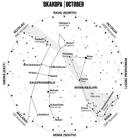
    This month the Hawaiian starline of Mānaiakalani becomes less prominent in our sky as we celebrate the arrival of Fall. It makes way for the starline of Kalupeokawelo, which will come to dominate our skies over the next couple of months. The starline of Kalupeokawelo, is known as The Kite of Kawelo, and it is composed of some asterisms (collections or patterns of stars) that may be familiar. The largest of these is the great square of Pegasus, which is the mythical winged horse of Greek mythology). This large formation of four bright stars is the body of the kite of Kawelo. The four stars of the Great Square are named for Hawaiian chiefs; Keawe of Hawaiʻi Island, Piʻilani of Maui, Kākuhihewa of Oʻahu, and Manokalanipo of Kauaʻi. From each corner star of the square we see celestial lines that are the guidelines of the kite. The lines are anchored in the northern sky to ʻIwakeliʻi, the constellation of Cassiopeia with its distinctive 'W' shape. There is also Kamōʻī, known as Cepheus the King in Greek mythology. In the southern sky they are held in place by Piʻikea, Diphda; Kaikilani, Ankaʻa; Kalanikauleleaiwi, which is the bright blue giant star Achernar;
Kūkaniloko, which is the star Fomalhaut; and Nālani, known as Alnair in Grus the Crane.
    The story of the kite goes something like this. One day Kawelo watched his cousin Kauahoa releasing a kite into the sky. Kawelo, inspired by the kite riding on the winds, returned home and asked his grandparents for a kite of his own. They obliged and the next day he took to the skies with his kite, alongside his cousin Kauahoa.The two boys were competitive and both Kawelo's and Kauahoa's kites became entangled in the sky. During the fray the string holding Kauahoa's kite broke, and the kite came loose, landing somewhere in a distant forest. To this day, near Koloa, is a place called Kaho'oleināpe'a in reference to Kauahoa's fallen kite. Kawelo and Kauahoa could have come to blows over the loss of the kite, which was arguably Kawelo's fault, but Kauahoa attributed the loss of the kite to the elements and was not angry at Kawelo. However, this apparent battle of kites was a powerful sign to those onlookers who witnessed the dramatic display. It was a sign that Kawelo's mana, or supernatural power, was greater than Kauahoa's.
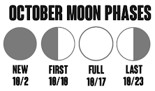
     Fountains of Fire: When we look up into our island skies on a dark, clear night, we see the bright band of the Milky Way galaxy extending from horizon to horizon. This river of light is composed of hundreds of millions of stars, all of which are part of the great spiral galaxy that we call home. At the center of our galaxy is one, or possibly more, supermassive black holes. These are the gravitational engines that drive the galaxy and give rise to its graceful and spectacular shape. Out there in the Universe there are other galaxies, galaxies in which there are far more dramatic views to behold and Big Island astronomers at the Keck observatory, atop Maunakea, have been the first to witness such a sight.


Artwork and observation of black hole jets. Image from W.M. Keck Observatory

    This spectacular sight is known as Porphyrion, named after a giant in Greek mythology. It is so distant that the light from it has traveled over 7.5 billion years to reach us, and as a result we are seeing it as it was around 7.5 billion years ago. So what is Porphyrion?
    Porphyrion is a pair of jets from supermassive black holes, these 'astrophysical jets' as they are known, are enormous, around 23 million light years across. That's 140 Milky way galaxies back to back, a vast fountain of fire of mind boggling size. The power of these jets is just as stunning as their size, with an equivalent power to that of trillions of suns. They erupt from the massive black holes and out into the cosmos. The galaxy from which the came cannot be seen, it is overwhelmed by the incredible power output from the dark engines within its core. These jets are so vast and energetic that it is thought that they are responsible for influencing the evolution of galaxies in the local Universe around them.
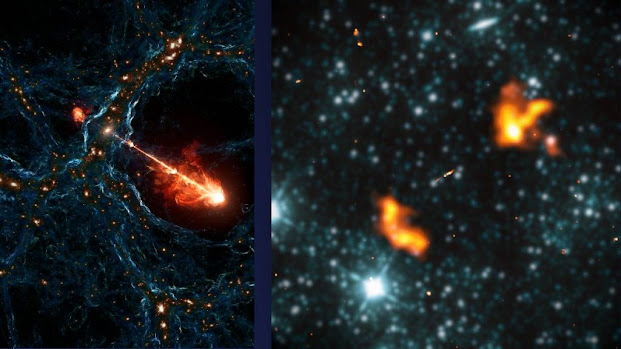
Image from NASA JPL/Caltech
    Thankfully these fountains of fire are confined to the early universe, and so our humble planet Earth is in no danger. However, it is a fascinating, and terrible reminder that the universe we live in is dominated by unimaginably powerful forces. Forces that are so great that they can shape the very universe around them. It is also a reminder that our existence is a result of the interplay of many of these forces. Not only are they capable of creating calamity in the cosmos, but they are also an important part of the circle of life in the universe, just as exploding stars (supernovae) are responsible for spreading the elements that make up life, and without them we wouldn't be here at all.

To read comments, add your own, and like this story, see facebook.com/kaucalendar. See upcomingevents, print edition and archive at kaunews.com.

FIRST LIGHT & FLIGHT FOR HVO'S NEW LIDAR SYSTEM is the title of this week's Volcano Watch, the weekly article and activity update written by U.S. Geological Survey Hawaiian Volcano Observatory scientists and affiliates. This article is written by HVO geologist/GIS specialist Mike Zoeller:
     Topographic mapping has been a key component of volcano monitoring for decades, helping scientists to study morphologic changes and predict the paths of lava flows during eruptions. Lidar systems are a preferred mapping tool and the USGS Hawaiian Volcano Observatory now has a lidar system of its own to generate mapping products more frequently than ever before.
Color photograph of lidar point cloud and photograph of volcanic cone
Left: A snapshot of the point cloud from HVO's September 5, 2024, lidar test flight along Kīlauea's Southwest Rift Zone, providing an east-looking oblique view of Pu'ukoa'e (upper left) and another unnamed cinder cone (lower right). Points are shown in true color thanks to a camera incorporated with the lidar system, and they taper out to the upper right of the frame, which was the edge of the planned survey area. Tick marks provide an approximate sense of scale, with the width of this view spanning approximately 450 m (1,475 ft). Right: Approximately the same view from a HVO helicopter overflight on February 6, 2024.  USGS image by M. Zoeller

    Lidar systems have become a preferred mapping tool due to the precision of their measurements and fine-scale resolution of their data products. Lidar (short for "light detection and ranging") systems operate by emitting many thousands of laser pulses per second, then recording the precise return times of the light waves after reflecting off different features in three-dimensional space. On Hawaiian volcanoes, these features are usually the surfaces of lava flows.     The return times are used to automatically calculate distances to those features, providing their X, Y, and Z coordinates when the instrument's position is precisely known. Compiling all the individual measurements results in a "point cloud" depicting the surveyed area.
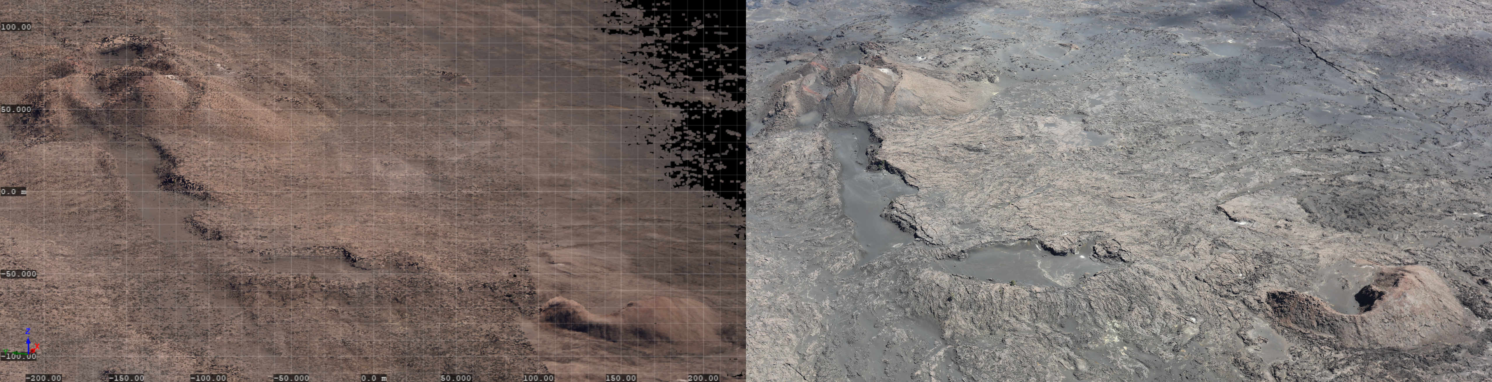
    For over 15 years, lidar systems have been used intermittently at Kīlauea and Mauna Loa volcanoes. These have included aerial systems such as the one contracted by HVO for a survey of Kīlauea in 2019, as well as ground-based terrestrial systems like the one HVO borrowed from the U.S. Army Corps of Engineers' Cold Regions Research and Engineering Laboratory (CRREL) for surveys of Halemaʻumaʻu in 2021–2023.
    Both system types require a GPS to record their position during the survey, but aerial systems also require a high-precision inertial measurement unit (IMU) to track directional roll, pitch, and yaw. These parameters are used for minute corrections of the instrument's position and orientation, allowing the measured features to correctly locate in the point cloud.

Color photograph of instrument mounted to the bottom of a helicopter
HVO's Riegl VUX-120 aerial lidar system mounted to belly of a contracted helicopter just before the September 5, 2024 test flight.
Photo by D. Filiano, U.S. Army Corps of Engineers
    Lidar systems are complex, and therefore expensive, so prior surveys on the Island of Hawaiʻi could only be conducted when permitted by the availability of funding and/or collaborators. That changed with Congress's passage of the Additional Supplemental Appropriations for Disaster Relief Act of 2019, which provided HVO with funds to purchase a lidar system among other upgrades in the aftermath of Kīlauea's 2018 eruption.
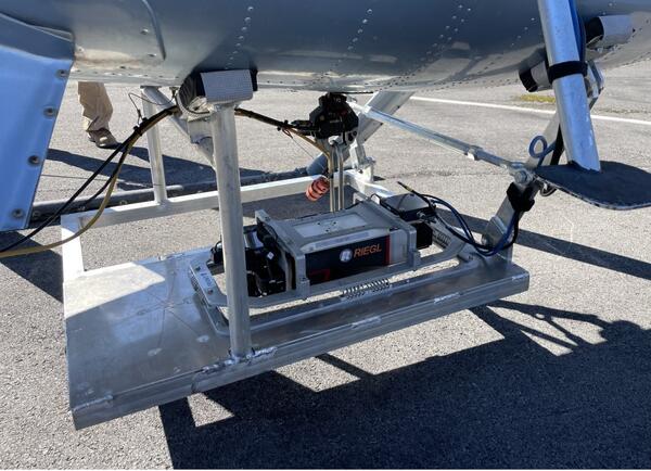
    In April 2022 HVO used the funds to purchase a Riegl VUX-120 airborne lidar system, mountable to a helicopter and enabling surveys of more expansive areas than a terrestrial system. The instrument arrived at HVO in November 2022, but it was not yet operational. Actually, using the VUX-120 would require the building of a mount to attach it to HVO's contracted helicopter and integrating the system with a control computer along with other accessories.
    The University of Hawaiʻi at Hilo's Spatial Data Analysis and Visualization (SDAV) Lab provided a template design for a helicopter mount, and for the integration, HVO again leaned on their collaborators at CRREL—who have operationalized various lidar systems of their own, including another VUX-120. The setup work was completed this past August.
    In early September, a technician from CRREL visited HVO to teach local staff how to use the VUX-120 and to assist during its first operation. The system successfully completed a ground test at HVO's warehouse in Hawaiʻi Volcanoes National Park on September 2, followed by its first flight aboard the contracted helicopter on September 5. For the first flight, HVO decided to survey the vicinity of the June 3, 2024, Kīlauea Southwest Rift Zone eruption.
    The test flight proved to be a resounding success; data were captured at a density of approximately 60 points per square meter (yard), enabling the construction of a high-accuracy digital elevation model (DEM) of the June 3 eruption vicinity. Some lessons were learned to further improve data quality in the future, which is especially important when the resulting DEMs may be used for critical assessments of volcanic hazards.
    HVO continues to rely on photographic surveys for rapid-response mapping of topography during eruptions, but the VUX-120 will provide more definitive datasets when time allows for its slightly longer-duration surveys (not possible during the recent, brief Kīlauea East Rift Zone eruption). To our knowledge, this is the only helicopter-mounted lidar system operated by anyone in the USGS, so there may be opportunities to use it elsewhere in support of hazard assessments and scientific research.
    HVO sincerely thanks the SDAV and CRREL teams for their support while we take our first steps into the world of airborne lidar, and we look forward to further collaboration in the future.
    Disclaimer: All trademarks and trade names are the property of their respective owners. Any use of trade, product, or firm names is for descriptive purposes only and does not imply endorsement by the U.S. Government.

Volcano Activity Updates
    Kīlauea is not erupting. Its USGS Volcano Alert level is ADVISORY.
    While the September 15–20 East Rift Zone eruption has ended, unrest continues at a low level in this region of Kīlauea. Over the past week, ending on Thursday, about 60 earthquakes were located in Kīlauea summit region, and about 50 were located in the upper-to-middle East Rift Zone. Ground deformation rates have greatly decreased since the eruption, but data show that magma is continuing to move at a low rate from the summit to the middle East Rift Zone. Future intrusive episodes and eruptions could occur with continued magma supply. The most recent measurement of sulfur dioxide (SO2) emission rate at the summit was 60 tonnes per day on September 17, 2024, and SO2 emissions were not detected at downwind of the eruption site on Monday, September 23.
    Mauna Loa is not erupting. Its USGS Volcano Alert Level is at NORMAL.
No earthquakes were reported felt in the Hawaiian Islands during the past week.
    HVO continues to closely monitor Kīlauea and Mauna Loa. Visit HVO's website for past Volcano Watch articles, Kīlauea and Mauna Loa updates, volcano photos, maps, recent earthquake information, and more. Email questions to askHVO@usgs.gov.

To read comments, add your own, and like this story, see facebook.com/kaucalendar. See upcomingevents, print edition and archive at kaunews.com.


Kaʻū News Briefs Oct. 3, 2024

KAʻŪ NATIVE PLANT OF THE MONTH is A'E (Zanthoxylum hawaiiens) in the column by author Jodie Rosam and artist Joan Yoshioka.
    Description: It is a pleasure to share October’s friend with you: meet aʻe! Aʻe is also the featured plant for the 2024 Run for the Dry Forest, happening October 19th at Puʻuwaʻawaʻa, so you get two opportunities to get to know more about this amazing tree. If you have never participated in the run (or walk) before, I highly encourage you to check it out. You may even walk away with an aʻe t-shirt (designed by Joan), a native plant, and a chance to see aʻe in person!
    Aʻe is a gorgeous endemic tree species in the Rutaceae or citrus family. This medium-sized tree most often grows to about 5-8m (16-25’) tall and about 25cm (10”) in diameter, though sometimes they can be much larger. Aʻe trunks are easily identifiable when walking through the forest - the pale and dark gray bark stands out among the rest. The opposite leaves are composed of 3 triangular-shaped leaflets that are a lovely shade of green. The leaflets can have a silver sheen to them from the fine hairs that grow on the surface. If you can get close enough, they are worth a sniff - aʻe leaflets smell like lemon oil. Aʻe are dioecious, meaning all flowers on a tree are either male or female. They form in clusters of about 20 and have 4 greenish-white, triangular petals. Fruits are shaped like miniature lemons and contain a single seed. Aʻe are a magnificent sight to see in Hawaiian forests, but this and all Zanthoxylum species are endangered. Wildfires, habitat fragmentation, and invasive plants, rats, and ungulates put aʻe more at risk
for extinction everyday. Like many of the species I have introduced you to, these plants need help to ensure its persistence.
    Uses: Beneath the gray bark of aʻe lies a lovely hard wood that when ground down, yields a yellow dye. The dense wood was also useful in creating kua kuku (kapa beating boards) and iʻe kuku (wooden kapa beaters), as well as ʻōʻō (digging sticks) and ōʻō ʻihe (throwing spears). I would imagine the lemony-scent yields some medicinal uses too, so if you know of any, please do share them! The fruits were likely a source of nutrition for the ʻalalā (Hawaiian crow, now extinct in the wild), and possibly the ʻōmaʻo (Hawaiian thrush).
    Habitat: Aʻe can be found at approximately 550-1,740m (1,800-5,700ft) elevation, growing on lava flows, dry forests, and mixed mesic forests - typically on the leeward sides of the islands. Formerly found on the islands of Kauaʻi, Hawaiʻi, Maui, Molokaʻi, and Lānaʻi, aʻe populations have declined so much that it may be extirpated from Lānaʻi and Kauaʻi. It was no doubt much more common than it is today, but unfortunately aʻe is becoming a rarity in native forests.
    Growing and Purchasing: Because of its rarity, aʻe is not used as an ornamental (but how great would it be if the State and County adopted a policy to plant uncommon native species into their grounds instead of things like autograph tree and non-native fan palms?!?!). If you would like to see aʻe in its native habitat and learn more about this treasured tree, please visit Puʻuwaʻawaʻa this month. Hope to see you on the trail!

To read comments, add your own, and like this story, see facebook.com/kaucalendar. See upcoming events, print edition and archive at kaunews.com.


EARLIER AGE DEATH IS ASSOCIATED WITH HEPATITIS C IN HAWAI'I, notes the state Department of Health in its campaign during Liver Cancer Awareness Month in October. DOH released Premature Deaths and Disparities Associated with Hepatitis C: The Hawaiʻi Hepatitis C Mortality Report. It analyzed mortality data from 2000 to 2021 to understand the burden of hepatitis C infections on local communities. DOH states that findings will guide efforts to improve liver health and reduce preventable deaths and says, "This novel report was the first comprehensive analysis of hepatitis C death data for Hawaiʻi." The most important findings include:
    People with hepatitis C die at a younger age than the general population. Most (88 percent) Hawaiʻi residents with hepatitis C-related deaths did not reach age 75, which was lower than the U.S. life expectancy in 2021.
    Many deaths occur before retirement age. Among Hawaiʻi residents with hepatitis C-associated deaths, more than 40 percent died before the average retirement age of 65 years (as compared to 23 percent for all causes of death).
    Progress is being made. Hepatitis C death rates were lower than the national average from 2017 to 2020, with 2.63 deaths per 100,000 in Hawaiʻi compared to 3.45 per 100,000 in the U.S. in 2020. However, disparities in death rates were observed for male and white residents in Hawaiʻi.
    To stem the tide of preventable deaths, the report makes recommendations on how to eliminate hepatitis C in Hawaiʻi, including universal reflex testing and increased access to curative medication. The report also prioritizes population-based data collection and analysis to share more information with community partners.
    "Deaths due to hepatitis C are completely preventable," said State Health Director Dr. Kenneth Fink. "Although Hawaiʻi has made progress in reducing these deaths, people are still dying unnecessarily from a curable infection. DOH is committed to working with our local coalition, Hep Free Hawaiʻi, and other partners to eliminate this deadly disease."
    The development of this report was the result of a multi-sector collaboration between DOH and external partners, including Hep Free Hawaiʻi and the Centers for Disease Control and Prevention (CDC). Download the report at https://health.hawaii.gov/harmreduction/new-early-deaths-due-to-hep-c-in-hawai%ca%bbi/.
    This report aligns with Hep Free 2030, the statewide strategy to eliminate viral hepatitis in Hawaiʻi by 2030, which was developed by DOH in collaboration with Hep Free Hawaiʻi and more than 160 community stakeholders.
    For local hepatitis C screening and treatment resources, visit www.hepfreehawaii.org.
    For free local hepatitis C provider training, visit https://uhpcme.teachable.com/p/hepatitis-c-training.
    For more information on hepatitis elimination efforts in Hawaiʻi, visit www.hepfreehawaii.org/hep-free-2030.

To read comments, add your own, and like this story, see facebook.com/kaucalendar. See upcoming events, print edition and archive at kaunews.com.


To read comments, add your own, and like this story, see facebook.com/kaucalendar. See upcoming events, print edition and archive at kaunews.com.