
MAPPING OF HOT ROCK, MAGMA AND THE EARTH'S MAGNETIC FIELD is taking place in
two projects starting on Kīlauea Volcano, including on Volcano National Park lands into Kaʻū, makai of Hwy 11 toward Punalu'u. The projects are the subject of Volcano Watch, the weekly column written by U.S. Geological Survey Hawaiian Volcano Observatory scientists and affiliates. This week’s article is by research geophysicist Jim Kauahikaua.
One project moves an instrument with wire coils put into ground from site to site. The other will employ a helicopter to fly an oblong wire loop. The target area is the entire volcano of Kīlauea—from the eastern point of Kumukahi southwest almost to Punaluʻu. Warning: many acronyms to follow! Both projects will determine the distribution of electrical resistivities below the surface that can be used to map magma and hot rock, among other things. The airborne project will also map variations in the magnetic field to determine how well the Earth's field is frozen into Kīlauea's magnetic minerals.
The first project deploys electrodes and wire coils buried at shallow depths to passively measure the electromagnetic (EM) energy generated by lightning strikes around the equator. The technique is called magnetotelluric (MT) sounding. Lightning storms are common in equatorial regions and those storms produce surprisingly constant electromagnetic noise that travels around the globe in the atmosphere between the Earth's surface and the ionosphere.
The response of the earth to this distant EM stimulation can tell us the electrical properties of the earth below the coils to depths of about 10 km (6 mi). The one-square-meter (yard) setup is being moved to about 125 ground locations on the volcano. The resulting data will be used to develop a detailed picture of Kīlauea's inner workings. This study is being done over two field seasons with the first season in 2022 during May and June. The second season will be in the summer of 2023.
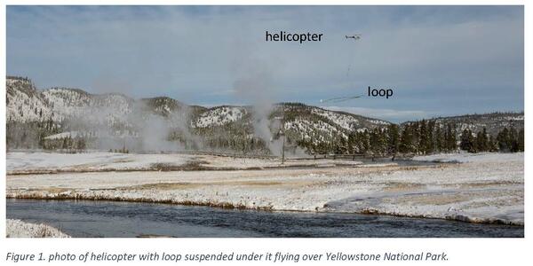
The second part of this project will use a 15 by 25 m (50 by 80 ft) oval-shaped wire loop suspended 30 m (100 ft) beneath a helicopter (Fig. 1) flying over most of the volcano. The loop assembly will transmit and receive very, very low frequency EM energy and will need to be flown 35–50 m (115–165 ft) above the ground or treetops. A small sensor will also be measuring magnetic field strength. The technique is called airborne electromagnetic and magnetic AEM mapping.
AEM data will complement the MT data and allow imaging of the shallow (upper 600 m or 2,000 ft) structure of the volcano including groundwater and patterns of alteration caused by hydrothermal fluids like those that seeped into Halemaʻumaʻu water lake in 2019–2020. Earth's magnetic field along the flight path will also map the signature of the cooling dike that transported magma to lower Puna in 2018. This part of the project was scheduled for 2022 in the months of June and July.
Currently planned flight lines do not fly over any residential areas or other regions excluded by the Federal Aviation Administration or Hawaiʻi Volcanoes National Park. Flights occur during daylight hours and are coordinated with the FAA. Experienced pilots specially trained and approved for low-level flying operate the helicopter. None of the instruments in either part of the project pose a health risk to people or animals.
AEM and Earth's magnetic field were last mapped in 1978 over both Kīlauea and Mauna Loa volcanoes. The 1978 results showed that Kīlauea's East Rift Zone was clearly outlined by a strong magnetic field aberration typical of vertical dikes that fed countless eruptions laterally from the summit area.
The equipment and software have been much improved in the past 20 years and the geophysicists overseeing the current project have successfully used the technique to map other US volcanoes. Our hopes are high that we will be able to more clearly image to greater depths in this new project to produce a picture of the entire magmatic system of Kīlauea. The final products of this survey will be made public within a few years.
The AEM survey should take about three weeks starting in late June. We understand that helicopter noise can be disruptive, so we will greatly appreciate affected residents' patience and understanding as we collect this extremely important data to help mitigate future eruption hazards.
The response of the earth to this distant EM stimulation can tell us the electrical properties of the earth below the coils to depths of about 10 km (6 mi). The one-square-meter (yard) setup is being moved to about 125 ground locations on the volcano. The resulting data will be used to develop a detailed picture of Kīlauea's inner workings. This study is being done over two field seasons with the first season in 2022 during May and June. The second season will be in the summer of 2023.

The second part of this project will use a 15 by 25 m (50 by 80 ft) oval-shaped wire loop suspended 30 m (100 ft) beneath a helicopter (Fig. 1) flying over most of the volcano. The loop assembly will transmit and receive very, very low frequency EM energy and will need to be flown 35–50 m (115–165 ft) above the ground or treetops. A small sensor will also be measuring magnetic field strength. The technique is called airborne electromagnetic and magnetic AEM mapping.
AEM data will complement the MT data and allow imaging of the shallow (upper 600 m or 2,000 ft) structure of the volcano including groundwater and patterns of alteration caused by hydrothermal fluids like those that seeped into Halemaʻumaʻu water lake in 2019–2020. Earth's magnetic field along the flight path will also map the signature of the cooling dike that transported magma to lower Puna in 2018. This part of the project was scheduled for 2022 in the months of June and July.
Currently planned flight lines do not fly over any residential areas or other regions excluded by the Federal Aviation Administration or Hawaiʻi Volcanoes National Park. Flights occur during daylight hours and are coordinated with the FAA. Experienced pilots specially trained and approved for low-level flying operate the helicopter. None of the instruments in either part of the project pose a health risk to people or animals.
AEM and Earth's magnetic field were last mapped in 1978 over both Kīlauea and Mauna Loa volcanoes. The 1978 results showed that Kīlauea's East Rift Zone was clearly outlined by a strong magnetic field aberration typical of vertical dikes that fed countless eruptions laterally from the summit area.
The equipment and software have been much improved in the past 20 years and the geophysicists overseeing the current project have successfully used the technique to map other US volcanoes. Our hopes are high that we will be able to more clearly image to greater depths in this new project to produce a picture of the entire magmatic system of Kīlauea. The final products of this survey will be made public within a few years.
The AEM survey should take about three weeks starting in late June. We understand that helicopter noise can be disruptive, so we will greatly appreciate affected residents' patience and understanding as we collect this extremely important data to help mitigate future eruption hazards.
-1.jpg)
Over the past week, lava has continued to erupt from the western vent within Halemaʻumaʻu crater. All lava is confined within Halemaʻumaʻu crater in Hawai‘i Volcanoes National Park. Sulfur dioxide emission rates remain elevated and were last measured at approximately 2,300 tonnes per day (t/d) on May 22. Seismicity is elevated but stable, with few earthquakes and ongoing volcanic tremor. Summit tiltmeters showed two deflation-inflation cycles over the past week. For more information on the current eruption of Kīlauea, see https://www.usgs.gov/volcanoes/kilauea/recent-eruption.
Mauna Loa is not erupting and remains at Volcano Alert Level ADVISORY. This alert level does not mean that an eruption is imminent or that progression to an eruption from the current level of unrest is certain. Mauna Loa updates are issued weekly.
This past week, about 50 small-magnitude earthquakes were recorded below the summit and upper elevation flanks of Mauna Loa—the majority of these occurred at shallow depths less than 15 kilometers (9 miles) below sea level. Global Positioning System (GPS) measurements show low rates of ground deformation over the past week. Gas concentrations and fumarole temperatures at both the summit and at Sulphur Cone on the Southwest Rift Zone have remained stable over the past week. Webcams show no changes to the landscape. For more information on current monitoring of Mauna Loa, see: https://www.usgs.gov/volcanoes/mauna-loa/monitoring.
One earthquake was reported felt in the Hawaiian Islands during the past week: a M4.7 earthquake 3 km (1 mi) NW of Hōlualoa at 9 km (5 mi) depth on May 21 at 11:49 p.m. HST.
HVO continues to closely monitor Kīlauea's ongoing eruption and Mauna Loa for any signs of increased activity.
Visit HVO’s website for past Volcano Watch articles, Kīlauea and Mauna Loa updates, volcano photos, maps, recent earthquake info, and more. Email questions to askHVO@usgs.gov.
To read comments, add your own, and like this story, see www.facebook.com/kaucalendar/. See latest print edition at www.kaucalendar.com. See upcoming events at https://kaunewsbriefs.blogspot.com/2022/04/upcoming-events-for-kau-and-volcano.htmltml
NO EXCUSES FOR DRIVING IMPAIRED warns the Hawai'i Police Department which is ramping up to catch motorists for DUI this coming Memorial Day weekend. A statement from HPD says, "The end of May is always a great time to reflect back and honor the soldiers who paid the ultimate price for our  freedoms as American’s. The first celebration of Memorial Day was observed on May 30, 1868 and has become a true American tradition. As we come together this holiday weekend the Hawai’i Police Department asks for your help in keeping the focus of Memorial Day on honoring the military men and women who have given so much for so many in our communities.
"If you have family and friends gathering together please celebrate Memorial Day safely. If anyone consumes any substance that could impair their ability to drive, please do your part to keep them safe from harming themselves or someone else. Have a plan, if you drink alcohol don’t drive. If you can stay where you are, then stay. If you have to leave, have a completely sober driver get you home.
"There are 'No Excuses' anymore for driving impaired. Call a friend, call your family, call a taxi or ride share. Please just don’t drink and drive. Memorial Day is about honoring those who protected our freedoms. The Hawai’i Police Department is dedicated to protecting the community and this weekend we will be focusing on preventing citizens from being injured or killed by impaired drivers. Officers will be on the lookout and will strictly enforce the law. Have a safe Memorial Day weekend."

"If you have family and friends gathering together please celebrate Memorial Day safely. If anyone consumes any substance that could impair their ability to drive, please do your part to keep them safe from harming themselves or someone else. Have a plan, if you drink alcohol don’t drive. If you can stay where you are, then stay. If you have to leave, have a completely sober driver get you home.
"There are 'No Excuses' anymore for driving impaired. Call a friend, call your family, call a taxi or ride share. Please just don’t drink and drive. Memorial Day is about honoring those who protected our freedoms. The Hawai’i Police Department is dedicated to protecting the community and this weekend we will be focusing on preventing citizens from being injured or killed by impaired drivers. Officers will be on the lookout and will strictly enforce the law. Have a safe Memorial Day weekend."
To read comments, add your own, and like this story, see www.facebook.com/kaucalendar/. See latest print edition at www.kaucalendar.com. See upcoming events at https://kaunewsbriefs.blogspot.com/2022/04/upcoming-events-for-kau-and-volcano.htmltml
concert at 11 a.m. at the Outdoor Pavilion behind United Methodist Church in Nāʻālehu. Students from Keoki Sereno's free 'ukulele classes will perform. Refreshments to follow.
SEE UPCOMING EVENTS IN KAʻŪ & VOLCANO

LEARN MORE ABOUT SPONSORS OF THE KAʻŪ CALENDAR



.jpg)


.jpg)


