About The Kaʻū Calendar

Sunday, December 11, 2022

Kaʻū News Briefs, Sunday, Dec. 11, 2022

Hawai'i Volcanoes National Park Superintendent Rhonda Low points to the proposed connector
trail for Pōhu'e Bay access. It would eliminate the need for hikers to traverse private land
when walking to Pōhu'e Bay. Photo by Peter Bosted

ESTABLISHING A CONNECTOR TRAIL FOR ACCESS TO PŌHUE BAY was put forth by Hawai'i Volcanoes National Park at a public input meeting on Saturday at Nāʻālehu Hongwanji. National Park Service staff set up stations for one-on-one discussions on managing the new Kahuku-Pōhu'e unit of the park. Among the topics were access, natural resources and education about the place. 
     The 16,000 acres were transferred to the National Park Service in July. Since then, park managers and advisors have met with focus groups and the public to garner ideas as to how the park should be managed. 
      Pōhu'e Bay is a key nesting ground for the endangered Hawaiian Hawksbill Turtle, and the site of a vast petroglyph field. A traditional Hawaiian mauka-makai trail meets the well known ancient Ala Kahakai trail at Pōhu'e Bay.
    Public access to Pōhu'e Bay has proponents and opponents. Hawai'i Volcanoes National Park Superintendent Rhonda Low explained that the park needs input as to how access should be managed. She asked how many people should be allowed to visit the coast? She asked whether day use and overnight use be limited. "People don't want the beach to be overwhelmed," she said.  Current park rules can limit the number of people in a backcountry campground to 16, she explained.
    A similar meeting was held in August in Ocean View, the Nāʻālehu meeting organized to draw in more of the Kaʻū community and beyond. 
     Prior to Hawai'i Volcanoes National Park acquiring the property from a private landowner, hikers could access Pōhu'e on a mauka-makai trial, while others drove a jeep road, providing they had keys to the gates.
Sierra McDaniels, HVNP's Acting Deputy Natural Resource Program Manager, 
adds public comments onto a large paper pad, while Candice and Rodney Crusat,
of Ocean View, give input. Photo by Peter Bosted
  Since development of Ranchos subdivision in Ocean View, the traditional hiking trail has started in Ranchos, and crossed private land before traversing the Kahuku-Pōhu'e  parcel to reach the ocean. 
    The right to use traditional trails on private and public land is guaranteed by the Highways Act dating back to 1892, which was established by Queen Liliuokalani. Hikers regularly use the mauka-makai trail and the Ala Kahakai Trail to reach Pōhu'e. Both of them pre-date 1892 and cross the Kahuku-Pōhu'e parcel.
    A jeep road to Pōhu'e afforded access for high-clearance, four-wheel vehicles. This route has been controlled with locked gates. Prior to the park's acquisition, only those members of the public who rented keys from the private property owner could use this route. The route still enters private land before returning to Park property. This part of the route has been of concern to park managers when considering allowing public access to Pōhu'e Bay.
    The Superintendent explained that the Park is proposing a new connector hiking trail measuring about a third of a mile. The connector, or spur, would bypass the part of the traditional trail that lies on private property and instead connect the jeep road to the part of the traditional trail that lies on Park property. If
This map shows the proposed connector trail in yellow, as is the parking area. The boundary
in bright orange/red shows Kahuku-Pōhu'e parklands makai of private properties. The
Ala Kahakai ancient trail is dotted in red. The jeep road is brown, inside the Park and blue
outside the Park. Map from NPS

approved, visitors would drive the jeep road for about two miles from the highway to a point close to the end of the Ranchos subdivision. Visitors wanting to reach Pōhu'e Bay would leave their vehicles at this trailhead, and hike the spur trail followed by a short distance on the jeep road, the rejoin the established historic trail. In this way, the need to use the part of the jeep trail that lies on private land would be eliminated.
    Loh said that there are no plans to improve the existing jeep road, which mandates four-wheel drive and
The Na'alehu public input meeting Saturday, on Kakuku-Pōhu'e Bay
unit of Hawai'i Volcanoes National Park. Photo by Nalani Parlin

high-clearance vehicles. 
    James Sutton, the Park's Facilities Manager, who would oversee construction of connector trail. told The Kaʻū Calendar that the trail would likely be built by hand.
    Jessica Ferracane, the Park's Public Affairs Specialist, added that the new trail may be built as early as 2023.
    Park personnel and advisors based questions or the public at the public meeting in Ocean View and Na'alehu on feedback from meetings with focus groups. Ferracane told The Kaʻū Calendar that the groups were Aha Moku, Kaʻū Multicultural Society, Hawai' Civil Club of  Kaʻū, Hana Laulima Lahui o Kaʻū, Kaʻū Advisory Council and Ala Kahakai Trail Association.
     
To read comments, add your own, and like this story, see www.facebook.com/kaucalendar. See latest print edition at wwwkaucalendar.com.

THE INCOMING CONGRESSWOMAN FOR KAʻŪ, JILL TOKUDA, announced recently that she has been elected to serve in two leadership positions within the Congressional Progressive Caucus and the
Congressional Asian Pacific American Caucus. The former state Senator, who lives in rural O'ahu and also serves all of the Neighbor Islands, is selected as Vice Chair for Communications in the Congressional Progressive Caucus.      "She will work closely with caucus leadership to craft messaging that advances issues and policies important to working families in Hawai'i and across the country," says a message from her organization. 
    In the Congressional Asian-Pacific American Caucus, she will serve as Freshmen Representative. "I want to thank my colleagues in the CPC and CAPAC for their trust and confidence in my ability to serve in these leadership roles," said Tokuda. 
    "I look forward to working with the leadership in both caucuses to advance the issues and policies that are important to our membership. More importantly, I am excited for the opportunity to use these new roles as a platform to elevate the voices of Hawaiʻi at the national level."

To read comments, add your own, and like this story, see www.facebook.com/kaucalendar. See latest print edition at wwwkaucalendar.com.
 
KĀHEA WAS LAUNCHED DURING THE MAUNA LOA ERUPTION, "where access to credible information is imperative for the community's health and safety," said Mayor Mitch Roth. Phase 1 of Kāhea has been in production for roughly a year and is focused on five primary
initiatives: emergency communications, traffic/roadwork information, transfer station closures and updates, relevant community updates regarding programs, services, etc., and a one-click County Directory.
    "We are trying our best to make sure that we do all we can to get important, relevant information directly into the hands of our community," Roth continued. "As we strive for a Hawaiʻi Island where our keiki can thrive and succeed for generations, we believe that access to viable, real-time information needs to be at the foundation."
    The app is not meant to replace existing County communication systems such as Everbridge or Civil Defense's emergency updates but, instead, to bolster and expand their reach. Residents are still encouraged to sign up for updates from all County departments that offer them. In addition, the County of Hawaiʻi website remains a wealth of information relating to day-to-day County business.
    The County reports that Kāhea will continue its rollout in phases, with Phase 2 expected to debut sometime in late 2023. The app is available on Apple and Android devices and can be found in their respective app stores. Kāhea is free to download and doesn't include any advertising.
   Phase 1 of the application came at no cost to taxpayers, as the AIO Family of Companies donated it. The Hawaiʻi County Council accepted the donation earlier this year.
       See https://www.dropbox.com/s/0nz1xir5v2osfpy/20221209_Kahea_AppPromo.mp4?dl=0

To read comments, add your own, and like this story, see www.facebook.com/kaucalendar. See latest print edition at wwwkaucalendar.com.

View of fissure 3 the morning of Dec. 10, after the lava pond replaced the fountains at the fissure 3 vent. The pond fed short lava flows that extended only 1.6 mi (2.6 km) from the vent and were already stagnating. USGS image by K. Mulliken 

NO LAVA IS LEAVING THE FISURE 3 VENT, according to the 3 p.m. update on the Mauna Loa lava flow on Sunday. Civil Defense reported: "The Hawaiian Volcano Observatory Mauna Loa Volcano alert level remains at Watch and HVO reports that Fissure 3 output is confined within the vent. There has been no new lava outside the vent and no communities are at risk.The Volcanic Alert Level-Watch means an eruption is underway but with limited hazards."
   Daniel K. Inouy Highway, the Saddle Road,  remains open in both directions.
   "The reduced level of activity is resulting in less red lava visible. You are reminded that all areas  to Daniel K. Inouye Highway, Old Saddle Road, and near the lava flow are closed and prohibited from access to the public for your safety," said the Civil Defense statement.

See The Ka'u Calendar in the mail and in stands from Volcano
through Miloli'i. Also see stories daily on facebook and at
www.kaunewsbriefs.blogspot.com


PICTURES WITH SANTA AT OV COMMUNITY CENTER
CHRISTMAS EVE, 1 P.M. TO 3 P.M.


Saturday, December 10, 2022

Kaʻū News Briefs, Saturday, Dec. 10, 2022

Congressman Kai Kahele brought every student at Nāʻālehu Elementary on Friday a personal letter from the
Congressman, a U.S. Constitution and House of Representatives swag. Photo from Kahele

Kai Kahele and leadership of
Nāʻālehu Elementary on Friday.
NĀ’ALEHU SCHOOL WAS CONGRESSMAN KAI KAHELE'S DESTINATION on Friday just off the plane for 72 hours in state. He travelled straight to Nāʻālehu Elementary School and said his aim was "to inspire 500 pre-K through sixth grade students in one of Hawai'i’s rural, country communities. Every student received a personalized letter, pocket constitution and U.S. House swag!" He proceeded to other schools in Hilo, including a Junior Achievement speakers program at Waiakea High School.
     Other news from Kahele this week, as he begins to wrap up his term in Congress, includes meeting with outgoing Speaker of the House Nancy Pelosi and incoming Democratic House Leader Hakeem Jeffries. 
Outgoing Speaker of the House Nancy
Pelosi and Kahele family.
    On Saturday, Kahele posted Ola i ka wai #ShutDownRedHill. He earlier posted: "#OnThisDayInHistory in 2021, I first raised the unfolding crisis at Red Hill in a House Armed Services Committee Democrats hearing with the U.S. Navy. In that bottle was petroleum contaminated water from faucets of military families homes that I collected earlier that week and brought to Washington. Exactly 270 days later the Secretary of Defense announced the permanent closure of #RedHill." On Saturday evening, Kahele posted: "Our ‘ohana was proud to “walk for wai” this afternoon to support Ernie Lau and the Honolulu Board of Water Supply to #ShutDownRedHill.
     The pollution of domestic water on O'ahu from the military storage of fuel in its Red Hill facility is one of the biggest stories in Hawai'i over the past year.
    This week, Kahele also honored the late Congresswoman Patsy Mink on her 95th birthday, saying: "The first Asian American Pacific Islander woman and first woman of color elected to the U.S. House, Congresswoman Mink championed #TitleIX and fearlessly fought to prevent discrimination across our nation’s educational institutions." Title IX says: "No person in the United States shall, on the basis of sex, be excluded from participation in, be denied the benefits of, or be subjected to discrimination under any education program or activity receiving Federal financial assistance." It is credited with women and all genders having increased participation in education and in school sports.
Protests on O'ahu on Saturday calling for immediate shutdown of Red Hill where pollutants from
military fuel storage have been polluting domestic water. Photos from Kai Kahele


THE CIVIL DEFENSE ERUPTION UPDATE for Saturday, Dec. 10 at 3 p.m. says, "Hawaiian Volcano Observatory has reduced the Mauna Loa Volcano alert level from Warning to Watch and reports that Fissure 3 continues to erupt with greatly reduced output of lava and gas emissions. Short outbreaks of lava continue above the 10,000 foot elevation and are no risk to any communities at this time. A Volcanic Alert Level, Watch means an eruption is underway but with limited hazards."
    Saddle Road, the Daniel K. Inouye Hwy, remains open in both directions.
    "The reduced level of activity is resulting in a minimal to no red lava viewing," says Civil Defense, reminding the public that all areas adjacent to Daniel K. Inouye Highway, Old Saddle Road, and near the lava flow are closed and "prohibited from access to the public for your safety. You will be updated of any changes that affect your safety."

 Aerial view of the fissure 3 cone on the Northeast Rift Zone of Mauna Loa. On Dec. 10, Hawaiian Volcano Observatory geologists noted there are no fountains present in fissure 3. Only a lava pond is present with minor circulating activity.
USGS Photograph by K. Mulliken


To read comments, add your own, and like this story, see www.facebook.com/kaucalendar. See latest print edition at wwwkaucalendar.com.

COMMUNITY INPUT ON THE FUTURE OF THE KAHUKU-PŌHU'E unit of Hawai'i Volcanoes National Park was gathered by the Park, Trust for Public Land and other partnering organizations for the planning of public access and other programs. The venue was Nāʻālehu Hongwanji on Saturday. See coverage in the Sunday Kaʻū News Briefs.
Community members gathered Saturday to give input on the future of the Kahuku-Pohue
unit of Hawai'i Volcanoes National Park. See coverage in Sunday's Kaʻū
 News Briefs.
Photo by Nalani Parlin
To read comments, add your own, and like this story, see www.facebook.com/kaucalendar. See latest print edition at wwwkaucalendar.com.
See The Ka'u Calendar in the mail and in stands from Volcano
through Miloli'i. Also see stories daily on facebook and at
www.kaunewsbriefs.blogspot.com


PICTURES WITH SANTA AT OV COMMUNITY CENTER
CHRISTMAS EVE, 1 P.M. TO 3 P.M.


Friday, December 09, 2022

Kaʻū News Briefs, Friday, Dec. 9, 2022

Hawaiian land snails, kāhuli, once numbered 750 species on the island and are the subject of an
art contest for the state Wildlife Conservation Stamp. Photo from DLNR
A CALL TO ARTISTS FOR IMAGES FOR A WILDLIFE CONSERVATION STAMP AND A GAME BIRD STAMP has come from the state department of Land & Natural Resources Division of Forestry & Wildlife. The wildlife conservation stamp is a requirement for Hawai‘i state hunting licensees while the game bird stamp is required for anyone intending to hunt game birds. Both stamps will also be available to stamp collectors.
    This year's chosen species for the artwork for the Wildlife Conservation stamp are kāhuli, Hawaiian land snails. Hawaiʻi once harbored over 750 species of land snails, almost all unique to individual islands. "These jewels of nature and culture are important components of island ecosystems from mauka to makai, and come in a variety of spectacular colors, shell shapes, and sizes," says the DLNR statement.
    The Game Bird Stamp will feature the chestnut-bellied sandgrouse, Pterocles exustus, a native to Africa
and Asia and an introduced game bird on Hawaiʻi Island. It can fly against the strongest Waimea winds and make diurnal migrations mauka to makai to collect water.
    The art must be oil or acrylic and show the snail or gamebird in its Hawai'i habitat and be a maximun size of 24" X 36". The submission must be the painting itself or an 8.5 X 11" photo, print or photocopy. Entries must be received by Feb. 25, 2023. Notification of the winner will be made in March 2023.
    All entries must be received by February 25, 2023. Notification of the winner will be made in March 2023. Each winner will receive a maximum award of $1,000. The winner of the Conservation Stamp will also get a behind-the-scenes tour (for themselves and 10 family or friends) of a captive rearing snail lab.
     Funds from Hawaii Wildlife Conservation Stamp sales go into the state Wildlife Revolving Fund to support wildlife populations and habitat, and to manage the states hunting program.
    Last year revenues from both stamps were used to cover some of the costs of maintaining hunting units and to add game bird and game mammal hunting opportunities where possible. Proceeds from the sales of wildlife conservation stamps will also provide funds for the annual lease rental of the Lānaʻi Cooperative Game Management Area and several other hunting leases while also supporting wildlife diversity programs.

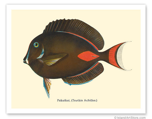
TAKING OF PĀKU‘IKU‘I, ACHILLES TANG, IS TEMPORARILY BANNED from South point up the west coast of the island. On Friday, the State Board of Land & Natural Resources approved the prohibition of harvesting pāku‘iku‘i, a popular aquarium collecting fish, within the West Hawai‘i Regional Fishery Management Area. This is the first time that the DLNR Division of Aquatic Resources (DAR) has adopted rules under the new adaptive management rulemaking authority, which allows the Department to approve temporary management measures in response to rapidly changing resource conditions.
    In revising the rules, DAR stated that "the change will allow for replenishment of the dangerously depleted pāku‘iku‘i fish population in the area as the Division works towards longer-term regulations for sustainable pāku‘iku‘i take"
    The new rules are set to begin Dec. 19, effective for a maximum of two years with the option to extend up to one year at a time upon approval by the BLNR and the Hawai‘i State Legislature.
   Department of Aquatic Resources is already working with coastal communities, including the community of Miloli'i, University of Hawaiʻi at Hilo, United States Geological Survey, and National Oceanic & Atmospheric Administration "to better understand pāku‘iku‘i life history traits that will support a more robust understanding of their stocks," says the DLNR statement.

A WIND ADVISORY FOR Hawaii Island is in place through Saturday morning. Sustained winds of 20 to 35 mph with localized gusts up to 55 mph are forecast. The National Weather Service also extended the High Surf Advisory for East facing shores of Hawai'i Island through Saturday morning.

MONITORING OF MAUNA LOA is the subject of this week's Volcano Watch, written by scientists and affiliates of USGS Hawaiian Volcano Observatory:
    The first few hours of Mauna Loa's eruption were dynamic, and volcanologists intently watched monitoring data to track changing conditions and understand how the eruption was developing. This monitoring is crucial to issuing hazards notifications to communities that may be at risk and is why we continue to closely monitor this new eruption.
    For months, monitoring data had indicated that Mauna Loa was inching closer to an eruption. The volcano had been inflating for years, and the past few months had seen an uptick in the rate of earthquakes. In late September 2022, HVO issued an Information Statement summarizing the increased activity, and by early October, daily, instead of weekly, activity updates were initiated. HVO also began holding community meetings in areas of the island that might be impacted by a Mauna Loa eruption, including Hawaiian Ocean View Estates, South Kona, and Pāhala.

Lava flow on Mauna Loa
Aerial view of Mauna Loa summit with Luahou in the foreground followed by Luahohonu, South Pit, and Mokuʻāweoweo summit caldera. A small dusting of snow covers the ground east of the summit. The steaming fissure was active during the beginning of the eruption, but this morning the lava in the summit caldera had already cooled to a black color. The white plume in the background is rising from the fissures in the Northeast Rift Zone. USGS photo J. Schmith

    The eruption started in Mokuʻāweoweo, Mauna Loa's summit caldera, at about 11:30 p.m. HST. The handful of scientists that responded to alarms about 45 minutes before the eruption quickly turned into an online meeting of 15–20 experts in seismology, deformation, geology, and satellite imagery. Additionally, Hawaiʻi County Civil Defense Agency (HCCDA) was immediately appraised of the volcano's behavior, both via the online meeting and with the addition of a volcanologist who quickly went to the HCCDA Emergency Operations Center in Hilo. Scientists from USGS volcano observatories in Alaska, California, and Washington also joined to assist.
 
The Northeast Rift Zone eruption of Mauna Loa continue into its
twelfth full day of Friday. One active fissure, fissure 3, feeds
 lava flows downslope to the north. USGS analysts  mapped
 some of the most active flows, displayed in red , along with
 older flows further uprift, in part of Mokuʻāweoweo caldera, and
 in the upper summit region southwest of the caldera. Lava
flow length was measured by tracing the continuous active channel
 shown in yellow here and then extending the measurement to
 the distal lava flow extent measured in satellite data.
 
  The primary concern was that the eruption might shift toward the Southwest Rift Zone (SWRZ). Lava from Southwest Rift Zone eruptions can reach populated areas within hours, so recognizing the early signs of a rift zone eruption is key.
    A few hours after the eruption started, images began to appear on social media of lava flows visible from Kona. In the dark, these flows looked menacing, and the public had clear concerns that the eruption had made its way into the Southwest Rift Zone. Indeed, the fissure that first opened in Moku'aweoweo continued opening towards the south, outside the topographic caldera, but still inside Mauna Loa's summit region. This produced the lava flow on the southwest side of the summit that was visible from the Kona coast. These flows did not threaten any populated areas and were ultimately short-lived.
    Monitoring data—ground tilt, seismic, cameras, thermal satellite, and infrasound (low-frequency sound)—continued to show that the eruption was focused at the summit. Volcanologists remained glued to their computer screens...
   By about 6 a.m. HST on November 28, reports from observers on the ground, as well as thermal satellite data, indicated that the eruption had moved into the Northeast Rift Zone. A few minutes later, this was confirmed by infrasound (low-frequency sound waves) and seismicity, and cameras showed that the summit-area eruption had stopped. With first light, volcanologists
 Aerial image of the lava channel issuing from fissure 3,
 erupting high on the Northeast Rift Zone of Mauna Loa.
 The reduced lava output at fissure 3 is evident in the low
 level of lava in the channel. Mauna Kea is visible in the
 background of the image. USGS image by P. Dotray


were in the air, on overflights and being shuttled to the eruption site to gather additional data and observations. But they began to breathe a bit easier. History suggests that once a Mauna Loa eruption moves into one rift zone, it stays there.
    Those tense first several hours served as a good test of how HVO is able to work with HCCDA officials and volcanologists from other USGS offices to rapidly respond to volcanic activity. Together, these agencies continue to monitor the Northeast Rift Zone eruption of Mauna Loa and keep the public informed on the activity.
    As of December 8, the main lava flow front that was approaching the Daniel K. Inouye Highway (Saddle Road) stalled about 1.7 mi (2.8 km) away. Lava continues to erupt from fissure 3 but these flows are now closer to the vent and are working their way downslope again.
    Future Mauna Loa eruptions, from the summit, either rift zone, or radial vents, are inevitable, but it is impossible to forecast precisely when those might happen. HVO's monitoring networks plus the high level of community awareness provide the best mitigation for hazards from any such eruption.
    HVO is grateful to the Island of Hawaiʻi for your support, awareness, and engagement during this latest eruption crisis. Mahalo nui loa and mālama pono.


PICTURES WITH SANTA AT OV COMMUNITY CENTER
CHRISTMAS EVE, 1 P.M. TO 3 P.M.


See The Ka'u Calendar in the mail and in stands from Volcano
through Miloli'i. Also see stories daily on facebook and at
www.kaunewsbriefs.blogspot.com